
Soil/Landform Unit 102
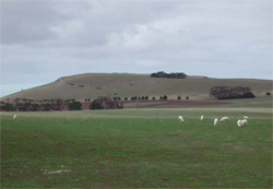
 This near face of this eruption point at Anakie East is being used for road base and other engineering purposes as the scoria is extracted from the south-eastern face of the cone. |
0.01% of CMA region The steep low cone south-east of Anakie belongs to a suite of eruption points across the Western Plains. With steep slopes, the cone has little remnant vegetation remaining (less than 0.5%) with the major vegetation class being Scoria Cone Woodland. These remnants occur mainly as reserves on upper slopes and crests, and footslopes. These cones have highly fertile side slopes and footslopes that have been used for cereal production, horticulture and as a source of scoria for road construction. The basaltic rock and scoria support shallow friable red texture contrast and gradational soils on the relatively steeper middle and upper slopes. The gentler lower slopes contain patches of shallow black self-mulching clay. Overland flow is likely on the steeper slopes. Nutrient leaching and decline are possible due to the shallow and permeable nature of gradational soils. | 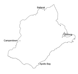 |
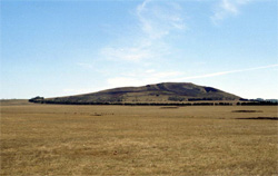
 Looking east across the basalt plains near Anakie towards volcanic cone | 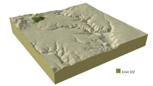 |
 | 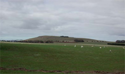 The main land use activity on the lower basalt slopes is grazing |
Component | 1 | 2 | 3 | 4 |
Proportion of soil-landform unit | 60% | 37% | 2% | 1% |
| CLIMATE Rainfall (mm) | Annual: 580 | |||
| Temperature (oC) | Minimum 9, Maximum 19 | |||
| Precipitation less than potential evapotranspiration | September-April | |||
| GEOLOGY Age and lithology | Quaternary scoria and basalt | |||
| Geomorphology | ||||
| LANDUSE | Uncleared: Nature conservation; passive recreation; water supply Cleared: Beef cattle and sheep grazing; water supply; cropping (cereal); horitculture (including potatoes); extraction pit - scoria | |||
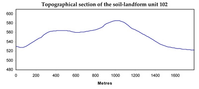
| TOPOGRAPHY Landscape | Steep low cones | |||
| Elevation range (m) | 148-283 | |||
| Local relief (m) | 60 | |||
| Drainage pattern | Radial and shut flow (poorly developed channels | |||
| Drainage density (km/km2) | - | |||
| Landform | Volcanic cone | Dissected plain and lower slopes | ||
| Landform element | Slope and crest | Long gentle upper slopes | Depressions | Stony rises |
| Slope and range (%) | 25 (5-40) | 1 (1-3) | 1 (1-2) | 3 (2-5) |
| Slope shape | Straight | Straight | Straight | Convex |
| NATIVE VEGETATION Ecological Vegetation Class | Scoria Cone Woodland (0.4%) | |||
| Dominant species | E. ovata, E. viminalis, E. rubida, E. obliqua | |||
| SOIL Parent material | In situ weathered basalt and scaoria | In situ weathered basalt | Alluvium | In situ weathered basalt |
| Description (Corangamite Soil Group) | Stony red gradational soil (40) | Black cracking clay soil, coarse structure (31) | Red shallow, stony gradational soil (40) | |
| Soil type sites | ||||
| Surface texture | Clay loam | Clay loam | Clay | Clay loam |
| Permeability | High | Moderate to low | Moderate | High |
| Depth (m) | 1 | 1.5 | 1.5 | 0.5 |
| LAND CHARACTERISTICS, POTENTIAL AND LIMITATIONS | Steep slopes causing overland flow is likely to cause sheet and rill erosion. Nutrient decline is possible due to shallow and pemeable soils. | Hardsetting surfaces and low permeability leads to overland flow. This flow often creates sheet and rill erosion with major rainfall events. Gully erosion and leaching of salts also occur. Surface compaction can benefit from controlled traffic. | Clay soils are prone to waterloggin. Sheet and rill erosion can occur with excessive rains and inadequate ground coverage. | Overland flow is likely to cause sheet and rill erosion. Nutrient decline is possible due to shallow and permeable soils. |
© State of Victoria (Agriculture Victoria) 1996 - .

This work, Victorian Resources Online, is licensed under a Creative Commons Attribution 4.0 licence. You are free to re-use the work under that licence, on the condition that you credit the State of Victoria (Agriculture Victoria) as author, indicate if changes were made and comply with the other licence terms.
The licence does not apply to ‘branding’ or some ‘images or photographs’ that may be owned by third parties. We ask you to seek prior approval to use images using the VRO feedback form. Access to higher quality images can also be provided on request.
This page was last updated on .