
Soil/Landform Unit 111
Landform Unit Description
Page top
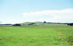 Robertson Hill located west of Colac has undulating slopes that graduate into long gentle slopes with deeper soils |
0.10% of CMA region The basalt and scoria hills of Wiridgil Hill and Robertson Hill consist of undulating hillslopes graduating into gentle slopes within the Western Plains. The low volcanic hills have given rise to black gradational soils with smaller areas of associated red texture contrast soils. The remnant vegetation (<2%) includes the classes Scoria Cone Woodland and Stony Rises Herb-rich Woodland. Soils are friable and productive but may be shallow and stony depending on landscape position. Land use is mainly dairy farming and grazing, with minor cereal cropping and other horticulture practices. The shallow soils tend to be susceptible to waterlogging (in wet seasons in depressions and drainage lines) and soil compaction. | 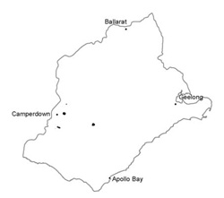 |
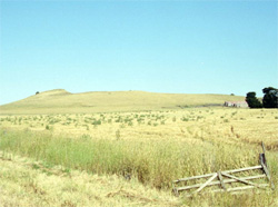 Slopes of the Wiridgil Hill north-west of Weerite |  |
 |
Component | 1 | 2 | 3 |
Proportion of soil-landform unit | 10% | 88% | 2% |
| CLIMATE Rainfall (mm) | Annual: 760 | ||
| Temperature (oC) | Minimum 8, Maximum 19 | ||
| Precipitation less than potential evapotranspiration | November-March | ||
| GEOLOGY Age and lithology | |||
| Geomorphology | |||
| LANDUSE | Uncleared areas: Nature conservation; water supply Cleared areas: Dairy farming; beef cattle and sheep grazing; cropping (cereal) | ||
| TOPOGRAPHY Landscape | Low hills | ||
| Elevation range (m) | 59-231 | ||
| Local relief (m) | 60 | ||
| Drainage pattern | Radial | ||
| Drainage density (km/km2) | 0.6 | ||
| Landform | Volcanic hill | ||
| Landform element | Crest | Side slopes | Crater and maar |
| Slope and range (%) | 8 (5-15) | 5 (3-10) | 0 |
| Slope shape | Convex | Convex | Concave |
| NATIVE VEGETATION Ecological Vegetation Class | Scoria Cone Woodland (1.4%), Stony Rises Herb-rich Woodland (0.2%) | ||
| SOIL Parent material | Scoria and ash | Scoria, ash, basalt and colluvium | Scoria and ash |
| Description (Corangamite Soil Group) | Neutral and acidic black gradational soils (40) | ||
| Soil type sites | |||
| Surface texture | Clay loam | Clay loam | Clay loam |
| Permeability | High | High to moderate | High (slopes) |
| Depth (m) | <1 | <1.5 | <1 |
| LAND CHARACTERISTICS, POTENTIAL AND LIMITATIONS | Friable structured soil. Soil depth may be only shallow to moderately deep with limited water holding capacity. Well drained and high nutrient holding capacity. Upper soil may be acidic. | Friable structured soil. Soil depth is moderately deep to deep with limited water holding capacity. Generally well drained and high nutrient holding capacity. Upper soil may be acidic. Texture contrast in places, less structured upper soil. | Friable structured soil. Soil depth may be shallow to moderately deep with limited water holding capacity. Well drained and high nutrient holding capacity. Upper soil may be acidic. |
© State of Victoria (Agriculture Victoria) 1996 - .

This work, Victorian Resources Online, is licensed under a Creative Commons Attribution 4.0 licence. You are free to re-use the work under that licence, on the condition that you credit the State of Victoria (Agriculture Victoria) as author, indicate if changes were made and comply with the other licence terms.
The licence does not apply to ‘branding’ or some ‘images or photographs’ that may be owned by third parties. We ask you to seek prior approval to use images using the VRO feedback form. Access to higher quality images can also be provided on request.
This page was last updated on .