
Soil/Landform Unit 36
Landform Unit Description
Page top
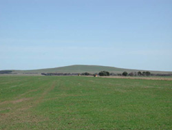
 The gently inclined low cone of Mount Widderin |
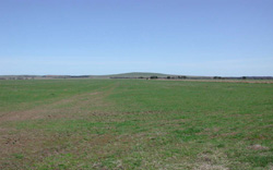
0.07% of CMA region The gently inclined slopes of low cones in the Cargerie area and Mount Widderin are derived from volcanic scoria, tuff and basalt. These volcanic eruption points on the Western Plains have nearly 60 m of local relief and are some of the most northerly cones on the Western Plains. The cones have been extensively cleared with little remnant vegetation (Plains Grassy Woodland - 0.2%) occurring as sporadic stands across the landscape and roadside reserves. Slopes have highly fertile loamy soils that have been used for grazing mainly due to the abundance of surface stone that limits cultivation. The basaltic rock, scoria and tuff support shallow red and black friable loamy soils, with the lower slopes supporting fewer surface stones and mottled texture contrast soils. Hardsetting surfaces, slowly permeable subsoils, and significant overland flow result in minor sheet and rill erosion. Periodic waterlogging also occurs in wet seasons. Areas with shallow stony gradational soils are susceptible to leaching of nutrients, and compaction is a problem on the lower slopes and flats. |  |
 The surrounding plains are mainly used for croping while the slopes of the low cones are mainly used for grazing | 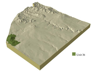 |
|
Component | 1 | 2 | 3 | 4 |
Proportion of soil-landform unit | 80% | 2% | 1% | 17% |
| CLIMATE Rainfall (mm) | Annual: 690 | |||
| Temperature (oC) | Minimum 7, Maximum 18 | |||
| Precipitation less than potential evapotranspiration | October-March | |||
| GEOLOGY Age and lithology | Pleistocene; basalt, scoria tuff | |||
| Geomorphology | ||||
| LANDUSE | Uncleared: Nature conservation; forest grazing Cleared: Beef cattle and sheep grazing; cropping (cereal) | |||
| TOPOGRAPHY Landscape | Low cone and gently inclined slopes | |||
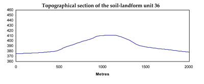
| Elevation range (m) | 280-411 | |||
| Local relief (m) | 60 | |||
| Drainage pattern | Radial and shut flow (poorly developed channels) | |||
| Drainage density (km/km2) | <0.1 | |||
| Landform | Depressions | Volcanic cone | ||
| Landform element | Long gentle upper slopes | Depression | Stony rise | Slope and crest |
| Slope and range (%) | 2 (1-3) | 1 (1-2) | 3 (2-5) | 25 (5-40) |
| Slope shape | Straight | Straight | Convex | Straight |
| NATIVE VEGETATION Ecological Vegetation Class | Plains Grassy Woodland (0.2%) | |||
| Dominant species | E. ovata, E. viminalis, E. Rubida, E. obliqua | E. viminalis, E. radiata | ||
| SOIL Parent material | In situ weathered basalt and scoria | Alluvium | In situ weathered basalt and scoria | In situ weathered basalt and scoria |
| Description (Corangamite Soil Group) | Black cracking clay soil, coarse structure (31) | Red shallow, stony gradational soil (40) | Stony red gradational soil (40) | |
| Soil type sites | ||||
| Surface texture | Clay loam | Clay | Clay loam | Clay loam |
| Permeability | Moderate to low | Moderate | High | High |
| Depth (m) | 1.5 | 1.5 | 0.5 | 1 |
| LAND CHARACTERISTICS, POTENTIAL AND LIMITATIONS | Hardsetting surfaces and slowly permeable subsoils result in significant overland flow. Sheet and rill erosion also occur from this overland flow. Soil compaction is also a limitation for soils with shallow topsoils. Periodic waterlogging also occurs. | Clay soils beside creeks are prone to periodic waterlogging. Streambank undercutting and streambank erosion is common. Slowly permeable subsoils are also quite sodic and prone to gully erosion. | Overland flow, nutrient leaching and decline all reflect highly permeable soils. Sheet erosion is common with excessive rainfall events. | Steep slopes and hardsetting surfaces result in significant overland flow. Sheet and rill erosion also occur from this overland flow. |
© State of Victoria (Agriculture Victoria) 1996 - .

This work, Victorian Resources Online, is licensed under a Creative Commons Attribution 4.0 licence. You are free to re-use the work under that licence, on the condition that you credit the State of Victoria (Agriculture Victoria) as author, indicate if changes were made and comply with the other licence terms.
The licence does not apply to ‘branding’ or some ‘images or photographs’ that may be owned by third parties. We ask you to seek prior approval to use images using the VRO feedback form. Access to higher quality images can also be provided on request.
This page was last updated on .