
Soil/Landform Unit 100
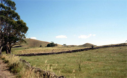 The stony slopes and crest of Mount Porndon |
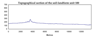
0.02% of CMA region This steep low cone of Mount Porndon is part of the eruption complex within the volcanic Western Plains of the south-west Corangamite region. This cone commands relatively high local relief and rapid site drainage. This cone is surrounded by the stony rise terrain (Unit 113), and has a number of landform components including crests, slopes and a maar. Native vegetation on the cone slopes and crests includes Stony Rises Herb-rich Woodland and Scoria Cone Woodland. The soils are shallow red and black gradational soils which are friable though often stony (basalt and scoria floaters and surface rocks) and are mainly used for grazing. They have a high nutrient holding capacity and permeability, but the steep slopes limit the range of possible land uses. These land uses also increase the susceptibility to sheet and rill erosion despite the soils’ aggregate stability. |  |
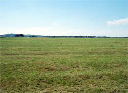 Lower slopes that have been cleared for cropping | 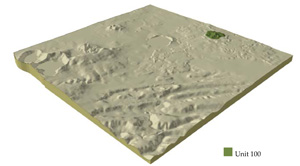 |
 | 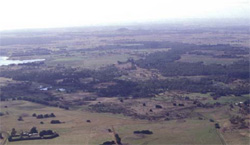 Stony rises surrounding Mount Porndon. Mount Porndon can be seen in the distance (appears as a low relief feature in this photo) |
Component | 1 | 2 | 3 | 4 |
Proportion of soil-landform unit | 12% | 3% | 55% | 30% |
| CLIMATE Rainfall (mm) | Annual: 820 | |||
| Temperature (oC) | Minimum 8, Maximum 18 | |||
| Precipitation less than potential evapotranspiration | November-March | |||
| GEOLOGY Age and lithology | Quaternary basalt and minor scoria | |||
| Geomorphology | ||||
| LANDUSE | Uncleared: Nature conservation; passive recreation Cleared: Veef cattle and sheep grazing; cropping; dairy | |||
| TOPOGRAPHY Landscape | Steep low cones | |||
| Elevation range (m) | 175-274 | |||
| Local relief (m) | 80 | |||
| Drainage pattern | - | |||
| Drainage density (km/km2) | - | |||
| Landform | Volcanic cone | |||
| Landform element | Ridges and crest | Maar | Steeper slopes | Lower slopes |
| Slope and range (%) | 4 (1-7) | 0 | 20 (15-32) | 10 (5-20) |
| Slope shape | Convex | Straight | Convex | Convex |
| NATIVE VEGETATION Ecological Vegetation Class | Stony Rises Herb-rich Woodland (5.3%), Scoria Cone Woodland (2.8%) | |||
| SOIL Parent material | In situ basalt and scoria | In situ basalt and scoria | In situ basalt and scoria | In situ basalt and scoria |
| Description (Corangamite Soil Group) | Shallow friable loams (40) | Shallow friable loams (40) | ||
| Soil type sites | ||||
| Surface texture | Clay loam or loam | Clay loam or loam | Clay loam or loam | High |
| Permeability | Very high | High | Very high | Very high |
| Depth (m) | <1 | <1.5 | <1 | <1.5 |
| LAND CHARACTERISTICS, POTENTIAL AND LIMITATIONS | Friable and strongly structured soils. Shallow soil. Well drained. Susceptible to wind erosion on southerly aspects. High nutrient holding capacity. | Friable and strongly structured soils. Shallow soil. Well drained on upper slopes only, generally very poorly drained. Susceptible to waterlogging and associated compaction. High nutrient holding capacity. | Friable and strongly structured soils. Shallow soils. Well drained. Susceptible to wind erosion on southerly aspects and some sheet erosion on steeper slopes. High nutrient holding capacity. | Friable and strongly structured soils, generally shallow soil, moderately well drained. High nutrient holding capacity. |
© State of Victoria (Agriculture Victoria) 1996 - .

This work, Victorian Resources Online, is licensed under a Creative Commons Attribution 4.0 licence. You are free to re-use the work under that licence, on the condition that you credit the State of Victoria (Agriculture Victoria) as author, indicate if changes were made and comply with the other licence terms.
The licence does not apply to ‘branding’ or some ‘images or photographs’ that may be owned by third parties. We ask you to seek prior approval to use images using the VRO feedback form. Access to higher quality images can also be provided on request.
This page was last updated on .