
Soil/Landform Unit 107
Landform Unit Description
Page top
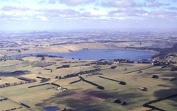 Water infilled volcanic maar of Lake Bullen Merri near Camperdown |
0.04 % of CMA region The maar complex in the south-west of the Corangamite catchment occurs near Camperdown and is associated with an eruption complex that includes low hills and plains (Unit 110) and low hills and rises as scoria cones (Unit 98). The water infilled maars comprise Lake Bullen Merri and Lake Gnotuk. As part of the volcanic Western Plains, the unit is characterised by steep to gentle inner rim slopes with water occupying the remainder of the unit. Associated with these inner slopes is the remnant vegetation class Scoria Cone Woodland. Soils are black texture contrast soils, are not sodic, have some friability and are better drained (particularly in the higher topographic positions), compared with the lower surrounding terrain, despite their texture contrast nature. Land use is mainly cropping and grazing along with nature conservation and water supply. The steep slopes are slightly susceptible to sheet and rill erosion. |
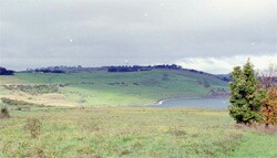
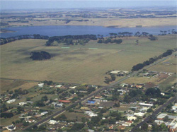 Looking over Camperdown towards Lake Bullen merri | 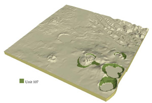 |
 |  Short inclined slopes of Bullen Merri |
Component | 1 | 2 |
Proportion of soil-landform unit | 70% | 30% |
| CLIMATE Rainfall (mm) | Annual: 800 | |
| Temperature (oC) | Minimum 8, Maximum 18 | |
| Precipitation less than potential evapotranspiration | November-March | |
| GEOLOGY Age and lithology | Quarternary scoria and Neogene marine sand, silt and marl | |
| Geomorphology | ||
| LANDUSE | Uncleared: Nature conservation; water supply; active and passive recreation Cleared: Cropping; beef cattle and sheep grazing; regional development | |
| TOPOGRAPHY Landscape | Maars and inner slopes of tuff rings | |
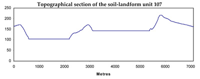
| Elevation range (m) | 100-260 | |
| Local relief (m) | 70 | |
| Drainage pattern | Radial | |
| Drainage density (km/km2) | 1.1 | |
| Landform | Inner slopes | |
| Landform element | Steep inner slopes | Lower moderate to gentle inner slopes |
| Slope and range (%) | 25 (15-50) | 10 (5-25) |
| Slope shape | Concave | Concave |
| NATIVE VEGETATION Ecological Vegetation Class | Scoria Cone Woodland (8.0%) | |
| SOIL Parent material | Basaltic scoria and ash | Basaltic scoria and ash |
| Description (Corangamite Soil Group) | ||
| Soil type sites | ||
| Surface texture | Fine sandy clay loam | Fine sandy clay loam, light medium clay |
| Permeability | Moderate to low | Very low |
| Depth (m) | <1.5 | >2 |
| LAND CHARACTERISTICS, POTENTIAL AND LIMITATIONS | Texture contrst, moderate to high water holding capacity and nutrient holding capacity depending on depth and stoniness. Firable, non-sodic soils with fine to moderate struucture. Very rapid site drainage. Susceptible to sheet and rill erosion. | Texture contrast, moderate to high water holding capacity and nutrient holding capacity depending on stoniness. Friable, non-sodic soils with fine to moderate structure. Rapid site drainage. Some susceptibility to sheet and rill erosion. |
© State of Victoria (Agriculture Victoria) 1996 - .

This work, Victorian Resources Online, is licensed under a Creative Commons Attribution 4.0 licence. You are free to re-use the work under that licence, on the condition that you credit the State of Victoria (Agriculture Victoria) as author, indicate if changes were made and comply with the other licence terms.
The licence does not apply to ‘branding’ or some ‘images or photographs’ that may be owned by third parties. We ask you to seek prior approval to use images using the VRO feedback form. Access to higher quality images can also be provided on request.
This page was last updated on .