
Soil/Landform Unit 101
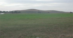
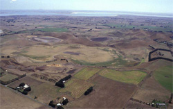 The volcanic hills offer great vantage points to view the neigbouring Lake Corangamite |
0.14% of CMA region This unit consists of a complex of low hills between the eastern shore of Lake Corangamite and Lake Colac. Near Coragulac, these low hills consist of a suite of volcanic landforms including maars, cones and basaltic slopes. The low hills offer a magnificent example of the Quaternary volcanics of the Western Plains and the scenic lookout ‘Red Rock’ is a highly visited location of the Corangamite region. Soils of the hill are predominantly black gradational soils with layers of volcanic ash encountered at a depth of 30–55 cm. Friable black and red loams occur on the steep hills and rims of the maars. Mottled black texture contrast soils also occur, mainly in drainage lines and depressions. Little remnant vegetation remains on these hillslopes and crests; the two main vegetation classes being Stony Rises Herb-rich Woodland and Scoria Cone Woodland. The agricultural land use is quite variable and includes beef cattle and sheep grazing, dairy farming, cereal cropping, horticulture, viticulture and recreation. Horticulture and cereal cropping is especially prevalent on the lower slopes. Given the relatively young parent material, these soils are generally friable and highly productive, but are often shallow. The shallow soils tend to be susceptible to waterlogging (in wet seasons in depressions and drainage lines) and compaction. | 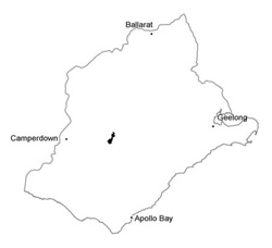 |
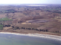 Maars and steep eruption points are pronounced throughout the unit | 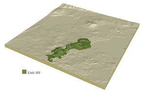 |
 |  Lower slopes surrounding the low hills are mainly used for cropping and horticulture |
Component | 1 | 2 | 3 | 4 |
Proportion of soil-landform unit | 15% | 5% | 30% | 50% |
| CLIMATE Rainfall (mm) | Annual: 660 | |||
| Temperature (oC) | Minimum 8, Maximum 19 | |||
| Precipitation less than potential evapotranspiration | October-March | |||
| GEOLOGY Age and lithology | Quaternary scoria and basalt | |||
| Geomorphology | ||||
| LANDUSE | Uncleared areas: Nature conservation; water supply Cleared areas: Sheep and beef cattle; dairy farming; cropping; horitculture; passive and active recreation | |||
| TOPOGRAPHY Landscape | Undulating low hills | |||
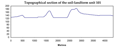
| Elevation range (m) | 118-273 | |||
| Local relief (m) | 65 | |||
| Drainage pattern | Radial | |||
| Drainage density (km/km2) | 0.9 | |||
| Landform | Hill | |||
| Landform element | Cones/hills/tumulus | Maar | Mid slopes | Footslopes/lower slopes |
| Slope and range (%) | 15 (10-40) | 0 | 11 (3-25) | 6 (2-15) |
| Slope shape | Convex | Straight | Convex | Concave |
| NATIVE VEGETATION Ecological Vegetation Class | Stony Rises Herb-rich Woodland (1.7%), Scoria Cone Woodland (1.2%) | |||
| SOIL Parent material | Ash and scoria | Ash and scoria | Scoria, ash and basalt | Scoria, ash and basalt |
| Description (Corangamite Soil Group) | ||||
| Soil type sites | ||||
| Surface texture | Clay loam | Clay loam | Clay loam | Clay loam |
| Permeability | High | High | Moderate to high | Moderate |
| Depth (m) | <1 | <0.7 | <1 | <1.5 |
| LAND CHARACTERISTICS, POTENTIAL AND LIMITATIONS | Friable structured soil. Soil depth may be shallow to moderately deep with limited water holding capacity. Well drained and high nutrient holding capacity. Uper soil may be acidic. | Frible structured soil. Soil depth may be shallow to moderately deep with limited water holding capacity. Well drained and high nutrient holding capacity. Upper soil may be acidic. | Friable structured soil. Soil depth may be shallow to moderately deep with limited water holding capacity. Well drained and high nutrient holding capacity. Upper soil may be acidic. | Friable structured soil. Soil depth may be only moderately deep with limited water holding capacity. Well to imperfectly drained and high nutrient holding capacity. Upper soil may be acidic. Drainage lines may be subject to waterlogging and compaction. |
© State of Victoria (Agriculture Victoria) 1996 - .

This work, Victorian Resources Online, is licensed under a Creative Commons Attribution 4.0 licence. You are free to re-use the work under that licence, on the condition that you credit the State of Victoria (Agriculture Victoria) as author, indicate if changes were made and comply with the other licence terms.
The licence does not apply to ‘branding’ or some ‘images or photographs’ that may be owned by third parties. We ask you to seek prior approval to use images using the VRO feedback form. Access to higher quality images can also be provided on request.
This page was last updated on .