
Landscape Units
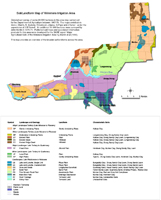 Soils/Landforms of the Wimmera Irrigation Area | Landscape and Soil Relationships in the Wimmera Irrigation Area
| |
Characteristic Features of Landscape Mapping Units
Landscape and Mapping Unit Symbol | Probable Original Vegetation | Characteristic Soil Type | Landform General Description |
| Gently Undulating Plains (GP) | Buloke, Spear and Wallaby grass | Kalkee clay | Undulating plains with long gentle slopes and occasional slight rises. |
| Moderately Undulating Plains (MP) | Buloke | Longerenong clay, Drung sandy clay loam | Moderately undulating plains. |
| Eroded Ridge Crest (EC) | Buloke | Kalkee clay, Drung sandy clay loam | Undulating plains, occasional sharp rises with associated depressions. |
| Eroded Plain (EP) | Buloke | Drung sandy clay loam, Longerenong clay, Kalkee clay | Level to gently undulating plains |
| Eroded Slope (ES) | Buloke | Drung sandy clay loam, Longerenong clay, Kalkee clay | Gentle to moderate slopes. |
| Flood Plain (FP) | Grey Box | Horsham clay, Murtoa clay, Drung sandy clay loam | Level areas, occasional slight rises. |
| Level Plain (LP) | Spear and Wallaby grass | Kalkee clay | Level areas. |
| High Plains (HP) | Spear and Wallaby grass, Grey Box, Box, Buloke and Yellow Gum | Type E, Drung sandy clay loam, Horsham clay and Murtoa clay | Level, gently undulating in some areas, typically sloping down to the Flood Plain unit. |
| Lake and Lunette (single unit) (LS) Lake and Lunette (clustered unit) (LC) | Black Box on lake beds, Buloke and occasionally grasslands on lunettes | Bungallally clay on lake beds, Drung sandy clay loam and Drung sandy loam on lunettes | Lake beds or depressions with rises, crescent shaped in plan, on eastern sides. |
| Dune and Swale (DS) | Brown Stringbark, Apple Box, Yellow Box and Yellow Gum with heath understorey | Quantong sand, Haven sandy loam, Haven sandy clay loam, Norton Sandy Clay | Sand sheets, sand dunes, typically east-west, interdune corridors. |
| Sand Plain (SP) | Box, Buloke and Yellow Gum Tall Woodland | Haven sandy loam, Quantong sand shallow phase and Murtoa clay | Level to gently sloping plain. |
| Prior Stream Flood Plain (PS) | (Grey) Box, Buloke and Yellow Gum, Spear and Wallaby grass | Murtoa clay, various red and grey soil complexes | Level plain, occasional slight rises, shallow stream courses and associated levees. |
| Black Box Flats (BB) | Black Box | Murtoa clay, Horsham clay | Level areas or narrow valley flats. |
| River Frontage (RF) | Black Box | Murtoa clay, various unclassified soils, Norton Sandy Clay | Generally narrow low lying often dissected areas bordering the Wimmera River. |
| Valley Floor (VF) | Black Box | Unclassified soils | A low lying area at the southern end of the Yarriambiack Creek. |
Location:
Soil Profile Morphology:
| Surface Soil | Depth (cm) | Description |
|---|---|---|
| Subsoil | Depth (cm) | Description |
|---|---|---|
Soil Profile Characteristics:
| pH | Salinity Rating | Sodicity | Dispersion | |
|---|---|---|---|---|
| Surface (A1 horizon) | ||||
| Subsoil (B21 horizon) | ||||
| Deep Subsoil (at cm) | ||||
| Surface (at cm) | ||||
Soil Profile Graphs:
Chemical Analysis
| Horizon | Horizon Depth (cm) | pH (water) | pH (CaCl2) | EC (dS/m) | NaCl % | Exchangeable Cations (meq/100g) | Organic Carbon | Oxidisable Organic Carbon g/100g | Total Nitrogen | Exchangeable Acidity meq/100g | Exchangeable Aluminium mg/kg | Exchangeable Boron mg/kg | Available Boron mg/kg | |||
|---|---|---|---|---|---|---|---|---|---|---|---|---|---|---|---|---|
| Ca | Mg | K | Na | |||||||||||||
Physical Analysis
| Horizon | Horizon Depth (cm) | Bulk Density g/cm3 | Field Capacity pF2.5 w/w g/g % | Wilting Point pF4.2 w/w g/g % | Coarse Sand (0.02-2.0mm) % | Fine Sand (0.02-0.2mm) % | Silt (0.02-0.002mm) % | Clay (<0.002mm) % | Gravel % |
|---|
Management Considerations
Whole Profile:
Surface (A) Horizons:
Subsoil (B) Horizons:
Landholder Comment:
Described By:
Reference:
© State of Victoria (Agriculture Victoria) 1996 - .

This work, Victorian Resources Online, is licensed under a Creative Commons Attribution 4.0 licence. You are free to re-use the work under that licence, on the condition that you credit the State of Victoria (Agriculture Victoria) as author, indicate if changes were made and comply with the other licence terms.
The licence does not apply to ‘branding’ or some ‘images or photographs’ that may be owned by third parties. We ask you to seek prior approval to use images using the VRO feedback form. Access to higher quality images can also be provided on request.
This page was last updated on .