
River Frontage
Map symbol: RF
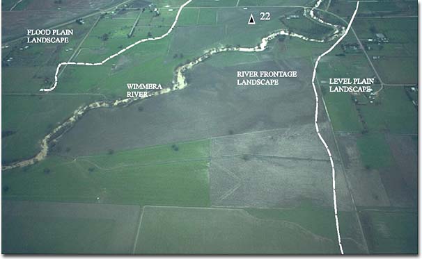
Units of the river frontage landscape unit border the Two Mile Creek east of Longerenong Agricultural College, the McKenzie River and the Wimmera River near Riverside, Horsham and Quantong. The landscape as a whole occupies a relatively small area. The flat to uneven ground surface is the lowest lying unit in the survey area. The lowest parts border the Wimmera River south and south east of Quantong. Some areas of native vegetation still remain in this landscape. Black Box is the dominant tree species and occurs singly and in fairly dense stands.
The characteristic soil type is Murtoa clay. Other soil types include Haven sandy loam, Haven sandy loam shallow phase, Quantong sand, Quantong sand shallow phase and Norton sandy clay. They occur mainly in the Quantong area where they occupy relatively small areas, often at different levels and separated by erosion gullies and stream courses.
© State of Victoria (Agriculture Victoria) 1996 - .

This work, Victorian Resources Online, is licensed under a Creative Commons Attribution 4.0 licence. You are free to re-use the work under that licence, on the condition that you credit the State of Victoria (Agriculture Victoria) as author, indicate if changes were made and comply with the other licence terms.
The licence does not apply to ‘branding’ or some ‘images or photographs’ that may be owned by third parties. We ask you to seek prior approval to use images using the VRO feedback form. Access to higher quality images can also be provided on request.
This page was last updated on .