
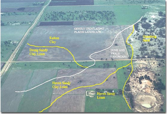
Dune and Swale
Map symbol: DS
The dune and swale landscape unit occupies the greater part of the survey area south and west of Horsham. Where dunes and swales occupy approximately equal areas, the dune and swale sequence gives a characteristic undulating profile to the ground surface. In other areas where sand sheets rather than sand dunes are the dominant landform the ground surface is flat to gently undulating. Fairly undisturbed stands of native vegetation remain in some areas. Tree species include Apple Box and Brown Stringybark on the dunes and Yellow Gum, Yellow Box and Grey Box on the swales. Yellow Gum may not occur where dune sandy surface soils are deep. Dune heath species include daphne heath, prickly tea-tree, silver banksia and twiggy guinea-flower. Coast banksia (B. marginata) may also occur on Quantong sand.
Characteristic soil types are Haven sandy loam, Haven sandy clay loam and Quantong sand. Haven sandy loam, Haven sandy clay loam and Quantong sand together occupy most of the landscape unit. Haven sandy loam, Haven sandy loam shallow phase and Haven sandy clay loam occur on the mid-level interdune swale areas. Murtoa clay, Norton sandy clay and Type D occupy the lower inter-dune swale areas and local slight depressions.
© State of Victoria (Agriculture Victoria) 1996 - .

This work, Victorian Resources Online, is licensed under a Creative Commons Attribution 4.0 licence. You are free to re-use the work under that licence, on the condition that you credit the State of Victoria (Agriculture Victoria) as author, indicate if changes were made and comply with the other licence terms.
The licence does not apply to ‘branding’ or some ‘images or photographs’ that may be owned by third parties. We ask you to seek prior approval to use images using the VRO feedback form. Access to higher quality images can also be provided on request.
This page was last updated on .