
Eroded Ridge Crest
Map symbol: EC
The eroded ridge crest landscape unit occurs only in the area north of Coromby. The landform is that of undulating plains with occasional relatively sharp rises and associated depressions. Buloke (Casuarina luehmanii) occur singly and occasionally in fairly dense stands.
The characteristic soil types are Drung sandy clay loam and Kalkee clay. They cover approximately equal areas and together occupy most of the landscape. Type B only occurs in this landscape. The Drung soils occur typically on pronounced rises and the Kalkee soils on the plains at a lower level.
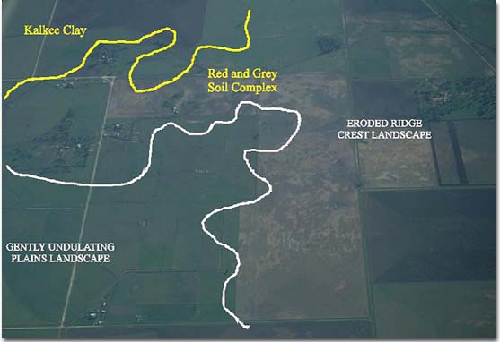
This photo shows the eroded ridge crest unit and adjacent gently undulating plains unit. Note the mix of soil types in the red and grey soil complex.
© State of Victoria (Agriculture Victoria) 1996 - .

This work, Victorian Resources Online, is licensed under a Creative Commons Attribution 4.0 licence. You are free to re-use the work under that licence, on the condition that you credit the State of Victoria (Agriculture Victoria) as author, indicate if changes were made and comply with the other licence terms.
The licence does not apply to ‘branding’ or some ‘images or photographs’ that may be owned by third parties. We ask you to seek prior approval to use images using the VRO feedback form. Access to higher quality images can also be provided on request.
This page was last updated on .