
Eroded Plain
Map symbol: EP
The four representative units of this landscape occur in the Dooen to Longerenong area. Landforms are level to gently undulating plains. The characteristic soil types include Drung sandy clay loam, Longerenong clay and Kalkee clay. The vegetation was probably Buloke. The accompanying landscape photograph was taken near the junction of the Henty and Wimmera Highways.
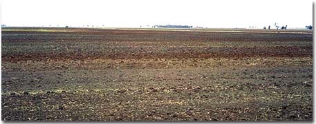
This photograph shows the variable soil types within this complex unit. At a depth of one metre, Tertiary period sandstone material was encountered in this area.
© State of Victoria (Agriculture Victoria) 1996 - .

This work, Victorian Resources Online, is licensed under a Creative Commons Attribution 4.0 licence. You are free to re-use the work under that licence, on the condition that you credit the State of Victoria (Agriculture Victoria) as author, indicate if changes were made and comply with the other licence terms.
The licence does not apply to ‘branding’ or some ‘images or photographs’ that may be owned by third parties. We ask you to seek prior approval to use images using the VRO feedback form. Access to higher quality images can also be provided on request.
This page was last updated on .