
Flood Plain
Map symbol: FP
The flood plain landscape unit occurs mainly south east of Horsham. Smaller units of the landscape occur east and south east of Quantong. The ground surface is level with occasional slight rises and depressions. On this landscape very little of the native vegetation remains. Grey Box and Yellow Gum rarely occur and Buloke occurs singly and occasionally in small stands.
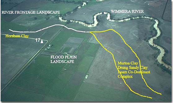
The characteristic soil types are Horsham clay, Murtoa clay and Drung sandy clay loam. They occupy approximately equal total areas. Drung sandy clay loam generally occurs on the crests and upper slopes of slight rises. Horsham clay occurs on the relatively level plains. Murtoa clay often occurs at slightly lower levels and in local slight depressions.
© State of Victoria (Agriculture Victoria) 1996 - .

This work, Victorian Resources Online, is licensed under a Creative Commons Attribution 4.0 licence. You are free to re-use the work under that licence, on the condition that you credit the State of Victoria (Agriculture Victoria) as author, indicate if changes were made and comply with the other licence terms.
The licence does not apply to ‘branding’ or some ‘images or photographs’ that may be owned by third parties. We ask you to seek prior approval to use images using the VRO feedback form. Access to higher quality images can also be provided on request.
This page was last updated on .