Your gateway to a wide range of natural resources information and associated maps

Victorian Resources Online

Sites of Geological and Geomorphological Significance - Ringwood Mapsheet

Back to: Port Phillip & Westernport - Sites of Geological and Geomorphological Significance

This is a clickable map. Click on Site in Legend for more information.
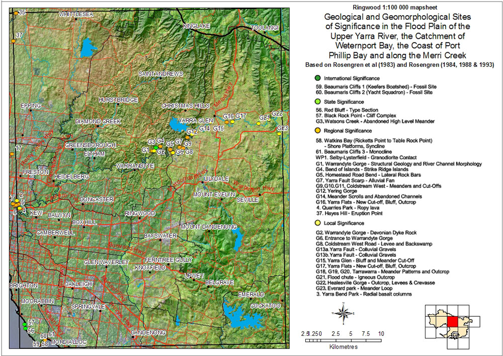
Sites of Geological and Geomorphological Significance - Ringwood Mapsheet 59 - Beaumaris cliffs 1 (Keefers Boatshed) - Fossil Site 60 - Beaumaris cliffs 2 (Yacht Squadron) - Fossil Site 56 - Red Bluff - Types Section 57 - Black Rock Point - Cliff complex G3 - Watons Creek 58 - Watkins Bay 61 - Beaumaris Cliffs 3 - Monocline WP1 - Selby-Lysterfield - Granodiorite contact G1 - Warrandyte Gorge - Structural geology and river channel morphology G4 - Bend of Islands - Strike Ridge Islands G5 - Homestead Road Bend - Lateral Rock Bars G7 Yarra Fault Scarp - Alluvial fan G9, 10, 11 Coldstream West - Meanders and Cut-offs G12 Yering gorge G14 Meander scross and abandoned channels G16, 17 Yarra Flats - New cut-off, bluff, outcrop 4 - Quarries Park - ropy lava 37 Hayes Hill - Eruption Point G2 Warrandyte Gorge G6 Entrance to Warrandyte Gorge G8 Coldstream West Road - Levee and Backswamp G13 Yarra Fault - Colluvial gravels G15 Yarra Glen - Bluff and meander cut-off G16, 17 Yarra Flats - new cut-off, bluff, outcrop G18, 19, 20 Tarrawarra - Meander Patterns and Outcrop G21 Flood chute - Igneous outcrop G22 Healesville Gorge - outcrop, levees and crevasse G23 Everard Park - meander loop 3 Yarra Bend park, Fairfield - Radial basalt columns

Ringwood mapsheet
International SignificanceLocal Significance
59 Beaumaris Cliffs 1 (Keefers Boatshed) - Fossil SiteG2 Warrandyte Gorge - Devonian dyke rock
60 Beaumaris Cliffs 2 (Yacht Squadron) - Fossil SiteG6 Entrance to Warrandyte Gorge
G8 Coldstream West road - levee and backswamp
State SignificanceG13a Yarra fault - Colluvial gravels
56 Red Bluff - Type sectionG13b Yarra fault - Colluvial gravels
57 Black Rock Point - Cliff complexG15 Yarra Glen - Bluff and meander cut-off
G3 Watsons Creek - Abandoned high level meanderG17 Yarra flats - New cut-off. bluff, outcrop
G18, G19, G20 Tarrawarra - Meander patterns and outcrop
Regional SignificanceG21 Flood chute - Igneous outcrop
58 Watkins Bay (Ricketts Point to Table Rock Point) - Shore Platforms, synclineG22 Healesville Gorge - Outcrop, levees & crevasse
61 Beaumris Cliffs 3 - MonoclineG23 Everard Park - Meander loop
WP1 Selby-Lysterfield - Granodiorite contact3 Yarra Bend Park - Radial basalt columns
G1 Warrandyte Gorge - Structural geology an river channel morphology
G4 Bend of islands - Strike ridge islands
G5 Homestead road bend - Lateral rock bars
G7 Yarra fault scarp - Alluvial fan
G9, G10, G11 Coldstream West - Meanders and cut-offs
G12 Yering Gorge
G14 Meander scross and abandoned channels
G16 Yarra Flats - New cut-off, bluff, outcrop
4 Quarries Park - Ropy lava
37 Hayes Hill - eruption point
Page top