
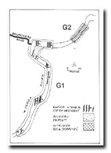
G1 - Warrandyte Gorge - Structural Geology and River Channel Morphology
|
This information has been developed from the publications:
|
| Location: | AMG Ref 462248, Yarra River channel and banks adjacent to Bouchiers Road. | 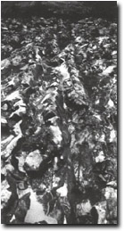 Outcrops transverse to channel from rapids in the Warrandyte Gorge (G1) |
Access: | Bouchiers Road off Menzies Road. | |
Geology: | Silurian siltstones of the Andersons Creek Formation outcrop in the river channel with a strike approximately north-south and easterly dip of 40o to 50o. | |
Geomorphology: | The site shows clearly the influence of rock structure in determining channel characteristics and the alignment of the valley. Resistant beds outcrop in the channel and form the rapids and islands in this site. | |
The angular nature of the bend and the straight section to the south are parallel to and determined by the north-south strike of the sediments. Small potholes on the rock surface illustrate a major process of stream abrasion and channel lowering. On the inside (east) of the bend opposite Bouchiers Road is a small depositional flat where the rock ridges are covered by a thin veneer of river alluvium. | ||
Significance: | Regional. This sector clearly illustrates the influence of local rock structures in determining channel alignment and pattern. The rock outcrops in the channel are exposed during normal river level. They are not obscured to any extent by vegetation or alluvial deposits, and bedding, dip, an strike can be readily determined. On the whole, the trend of the river channel between Warrandyte and the Yering Gorge is either transverse or oblique to the strike of the rocks with only short sectors aligned parallel to strike. Hence, the sector indicated for this site is representative of that general character. | |
Management: | Class 2. No structures that would obscure the major rapids should be permitted in the area of the site. | |

© State of Victoria (Agriculture Victoria) 1996 - .

This work, Victorian Resources Online, is licensed under a Creative Commons Attribution 4.0 licence. You are free to re-use the work under that licence, on the condition that you credit the State of Victoria (Agriculture Victoria) as author, indicate if changes were made and comply with the other licence terms.
The licence does not apply to ‘branding’ or some ‘images or photographs’ that may be owned by third parties. We ask you to seek prior approval to use images using the VRO feedback form. Access to higher quality images can also be provided on request.
This page was last updated on .