
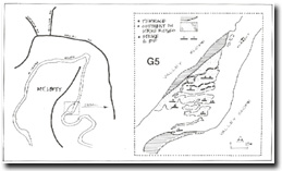
G5 - Homestead Road Bend - Lateral Rock Bars
|
This information has been developed from the publications:
|
| Location: | AMG Ref: 492250. | 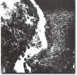 Detail of Rock bars at Homestead Road bend |
Access: | Henley Road or Hughes Road. | |
Geology: | Outcrops of Dargile Formation sandstone strike east-west across the channel and dip northwards at 25o. | |
Geomorphology: | The outcrops serve as a nucleus for deposition of sand and mud and this accumulation has been built up by floods to be above normal river level. There are now several elongate and parallel islands transversed by narrow gutters and channels. The outcrops deflect the channel to the east and this causes the meander neck to the south to become progressively narrower. | |
Significance: | Regional. This is the best example of this type of meander deflection in the study area and illustrates clearly the development of an ingrown meander. | |
Management: | Class 1. No disturbance to the rock bars or adjacent terraces should be permitted e.g. quarrying, roadworks or river re-alignment. | |
Homestead Road Bend - Lateral Rock Bars

© State of Victoria (Agriculture Victoria) 1996 - .

This work, Victorian Resources Online, is licensed under a Creative Commons Attribution 4.0 licence. You are free to re-use the work under that licence, on the condition that you credit the State of Victoria (Agriculture Victoria) as author, indicate if changes were made and comply with the other licence terms.
The licence does not apply to ‘branding’ or some ‘images or photographs’ that may be owned by third parties. We ask you to seek prior approval to use images using the VRO feedback form. Access to higher quality images can also be provided on request.
This page was last updated on .