
58. Watkins Bay (Ricketts Point to Table Rock Point) - Shore Platforms, Syncline
|
This information has been developed from one or more of these publications:
|
| Location: | 269928 to 276925. The site extends from the northern side of Ricketts Point to the eastern side of Table Rock Point. | |
Access: | Beach Road, Beaumaris. There is an extensive parking area at Ricketts Point. | |
Ownership: | Crown land, City of Sandringham. | |
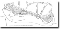
Geology/Geomorphology: | This large site includes several separated but related features. The site has structural, palaeontological and geomorphological significance. The shore platform exposed at low tide at Ricketts Point extends seaward over 150 m, and is by far the widest of any platform on the eastern coast of Port Phillip Bay. The platform is of hard, ferruginous Black Rock Sandstone and the lithology and structure of these beds is well displayed. The beds dip northeast and decline towards Watkins Bay, but reappear at Table Rock Point with an opposing dip (to the southwest). This structure has the appearance of a syncline with an axis trending northwest between the two point and the Black Rock Sandstone being warped down between them below present sea level. Several such undulating structures occur in the Black Rock Sandstone from Green Point southward - the antiform (arched) elements forming the base of headlands (eg - Picnic Point, Red Bluff, Black Rock) and the synform (trough) elements forming the intervening bays where the softer Red Bluff Sand is at sea level and has been eroded. The structure may be of tectonic origin but may also be a depositional feature resembling long period undulating sand waves (sand bars) in the upper beds of the formation. | |
| The outer edges of the shore platform are indistinct and generally covered by a coarse, bouldery rubble. Inland of Ricketts Point (north of Reserve Road), is a low bluff, formerly a marine cliff cut in Red Bluff Sand with a shore platform now covered by dunes and beach sand. This bluff and platform may be relict from a higher sea level period. | ||
At Table Rock Point beings the first of the high vertical cliffs that fringe Beaumaris Bay. These cliffs are cut manly in Black Rock Sandstone, this rock having been elevated by an anticline with the axis lying parallel to the Watkins Bay syncline. At Table Rock Point, the dip of the beds is southwest and can be readily measured in the cliffs and shore platform at the point. The cliffs at Table Rock Point are more influenced by marine processes than surface runoff (the reserve is the case at Red Bluff and Black Rock Point), and are vertical to undercut rather than sloping and lack deep rills and tunnels. Small sea caves have developed at the base of Table Rock Point. | ||
Significance: | Regional. This is the best site to display the structure of the Black Rock Sandstone and the influence of the anticline/syncline sequence in determining coastal morphology. The site makes a useful comparison with Red Bluff and Black Rock Point in regard to form and geomorphological processes and provides a rare example of sea cave formation in Port Phillip Bay. Access is easy and safe for school children. The inland bluff is the only example of this feature on the Melbourne coast and presents an interesting problem of interpretation. | |
Management: | Class 2. The present design of facilities at Ricketts Point and Table Rock Point (eg - parking, launching, pathways) is suitable for maintaining the geological features. No protective structures or constructions that would lead to sand deposition over the platforms should be built. | |
References: | Hall, T.S. & Pritchard, G.B. (1897). Note on a tooth of Palorchestes from Beaumaris. Proc. R. Soc. Vict., 10, 57-59. Singleton, F.A. (1941). The Tertiary geology of Australia. Proc. R. Soc. Vict., 53, 1-125. Gill, E.D. (1949, 1950). Nomenclature of certain Tertiary sediments near Melbourne, Victoria. Proc. R. Soc. Vict., 62, 165-171. Kenley, P.R. (1967). Geology of the Melbourne district - Tertiary. Bull. geol. Surv. Vict., 59, 34-56. Kenley, P.R. (1971). in VandenBerg, A.H.M., Explanatory notes on the Ringwood 1:63,360 geological map. Rep. geol. Surv. Vict., 1971/1. King, R. L., Cochrane, R.M. & Cooney A.M. (1987). Significant geological features along the coast in the City of Sandringham. Unpub. rep. geol. Surv. Vict., 1987/35. | |

© State of Victoria (Agriculture Victoria) 1996 - .

This work, Victorian Resources Online, is licensed under a Creative Commons Attribution 4.0 licence. You are free to re-use the work under that licence, on the condition that you credit the State of Victoria (Agriculture Victoria) as author, indicate if changes were made and comply with the other licence terms.
The licence does not apply to ‘branding’ or some ‘images or photographs’ that may be owned by third parties. We ask you to seek prior approval to use images using the VRO feedback form. Access to higher quality images can also be provided on request.
This page was last updated on .