
G18, G19, G20 - Tarrawarra - Meander Patterns and Outcrop
|
This information has been developed from the publications:
|
| Location: | AMG Ref: 608304. Tarrawarra. | 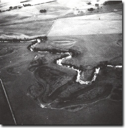 South of Tarrawarra |
Access: | Tarrawarra Road to north side of river. | |
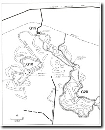
Geomorphology: | Sites G18 and G20 show meander patterns of the Yarra. At G18 there is a fine example of an anvil or "T" meander with three imminent cut-off localities that will substantially alter the river alignment. At G20 there are complex cut-off patterns similar to those that will develop at G18. G19 Humevale Formation outcrops on the north bank of the river. | |
Significance: | Local. G18, G19, G20. The two meander sites are representative of the larger meander forms on the Yarra flats. The G19 site illustrates the structural control of the northern margin of the floodplain. | |
Management: | Class 2. As public access is available to G19, a river access sign on the Healesville Road could be provided. | |
G18, G19, G20 - Tarrawarra - Meander Patterns and Outcrop

© State of Victoria (Agriculture Victoria) 1996 - .

This work, Victorian Resources Online, is licensed under a Creative Commons Attribution 4.0 licence. You are free to re-use the work under that licence, on the condition that you credit the State of Victoria (Agriculture Victoria) as author, indicate if changes were made and comply with the other licence terms.
The licence does not apply to ‘branding’ or some ‘images or photographs’ that may be owned by third parties. We ask you to seek prior approval to use images using the VRO feedback form. Access to higher quality images can also be provided on request.
This page was last updated on .