
G12 - Yering Gorge
|
This information has been developed from the publications:
|
| Location: | AMG Ref: 520270. | 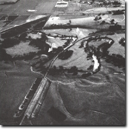 Dargile formation outcrops in the cliffs (A), and forms rapids (R) at Yering gorge. the slope foot (s) is a colluvial fan. |
Access: | Skyling Road, Henley Road. | |
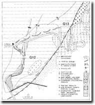
Geology: | The area of the gorge includes six main geological materials. 1. Sandstone and interbedded siltstone and shale of the Dargile Formation is the bedrock of the area. These outcrop on the valley slopes and form rapids in the river channel. The strike of the beds is broadly north-south although it is variable around the axes of plunging fold structures. | |
2. A small dyke of quartz of porphyry occurs across the base of the spur opposite the pumping station and on the northern side of the river channel just south of the pumping station. | ||
3. Soil profiles indicate a very thin outlier of tertiary basalt occurs as a small residual capping on the ridge to the east of the gorge. | ||
4. Colluvium has accumulated at the base of the slope adjacent to the river at the southern end of the gorge. | ||
5. Thin beds of gravels and sands occur 10 to 20 metres above river level just upstream of the gorge. These gravels are alluvial deposits stranded as the river became incised into the gorge downstream. | ||
6. Alluvium formed by action of the modern river flanks the Yarra at the entrance to the gorge and is extensive upstream to the east of the river. | ||
Geomorphology: | The Yering Gorge is a short tract of river incised into resistant rock to a depth of 60 to 80 metres. It is a relatively shallow and asymmetrical valley with several discontinuous short steep valley side slopes. Rapids occur where strike ridges of sandstone cross the channel obliquely. Narrow colluvial terraces border the stream at the lower end of the gorge. Hills (1934) and Garratt (1973) interpret the gorge as an incised meander o the Yarra cut into the hard rock strata during slow or intermittent uplift during the later Tertiary and early Quaternary movement of the Yarra Fault. | |
Significance: | Regional. The area displays several features relevant to the analysis of the origin of the western margin of the Yarra flats or floodplain. | |
Management: | Class 2. Present land management allows for adequate display of the relevant geological and geomorphological features. Flooding of the gorge due to reservoir construction would obscure most of the major features of significance e.g. rapids, higher level alluvium and colluvium and the major outcrops of Dargile Formation. | |

© State of Victoria (Agriculture Victoria) 1996 - .

This work, Victorian Resources Online, is licensed under a Creative Commons Attribution 4.0 licence. You are free to re-use the work under that licence, on the condition that you credit the State of Victoria (Agriculture Victoria) as author, indicate if changes were made and comply with the other licence terms.
The licence does not apply to ‘branding’ or some ‘images or photographs’ that may be owned by third parties. We ask you to seek prior approval to use images using the VRO feedback form. Access to higher quality images can also be provided on request.
This page was last updated on .