
G9, G10, G11 - Coldstream West - Meanders and Cut-Offs
|
This information has been developed from the publications:
|
| Location: | AMG Ref: 510250, 513252, 518259. | 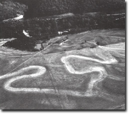 Elongate meander - A, Recent Cut-off - B, Fan-shaped meander - C |
Access: | Henley Road and Coldstream West Road. | |
Geomorphology: | The site includes three adjacent localities with different meander and cut-off characteristics. G9 includes an elongate meander where a cut-off is imminent as the neck is less than 10 metres wide in places. An earlier cut-off similar form is evident on the west of the river. At G10 there is a recently formed cut-off probably one of the youngest in the study area. At G11 the meander is fan-shaped rather than elongate. Upstream, the channel is straight where it emerges from the Yering Gorge and is flanked by low levee banks breached by flood crevassing. | |
The floodplain between Henty Road and Hughes Road is an alluvial basin contained between the Yering Gorge and the upper reaches of the Warrandyte Gorge. Because of the containment, flooding may have been more frequent, contributing to the growth of well defined levee banks below the Henley Road bridge. | ||
Significance: | Regional. The area is selected on the basis of the contrasting meander forms and the several stages of cut-off development included. The cut-off (G10) is one of the least modified on the floodplain in the study area. | |
Management: | Class 2. No drainage or other reclamation work should be permitted at G10 and removal of sand from the levee at G11 should be limited to small areas. | |
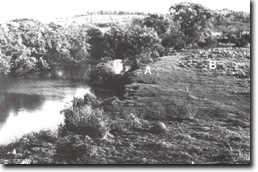 Levee bank/floodplain, Levee - A, Backswamp B. | 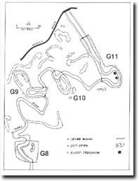 Coldstream West Road Levee and Backswamp |

© State of Victoria (Agriculture Victoria) 1996 - .

This work, Victorian Resources Online, is licensed under a Creative Commons Attribution 4.0 licence. You are free to re-use the work under that licence, on the condition that you credit the State of Victoria (Agriculture Victoria) as author, indicate if changes were made and comply with the other licence terms.
The licence does not apply to ‘branding’ or some ‘images or photographs’ that may be owned by third parties. We ask you to seek prior approval to use images using the VRO feedback form. Access to higher quality images can also be provided on request.
This page was last updated on .