
59. Beaumaris Cliffs 1 (Keefers Boatshed) - Fossil site
|
This information has been developed from one or more of these publications:
|
| Location: | 280931. Coastal cliffs at, and extending south of Keefers Boatshed site. | 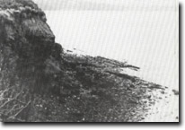 Site 59, Cliffs near Keefers Boatshed |
Access: | Beach Road (parking area between Keys Street and Bodley Street). | |
Ownership: | Crown land, City of Sandringham. | |
Geology/Geomorphology: | The coast is a steep to vertical and undercut cliff of Black Rock Sandstone. There is only a narrow shore platform and the numerous large blocks of fallen sandstone at the cliff base make traversing this section difficult and restricted to low tides. This long sequence of steep cliffs lies parallel to the axis of the Beaumaris Monocline, a major tectonic structure aligned northeast-southwest with a downthrow to the southeast. This structure determines the coastal orientation between Table Rock Point and Charman Road. The Black Rock Sandstone is 15 m thick and outcrops in the cliffs, the platform, and as small reefs parallel to the coastline. At the base of the cliffs is a thin calcareous sandstone overlain by fine sandy marl and sandstone with calcareous concretions. Higher in the cliffs the beds are ferruginised, with hard ironstone in the upper sections. The lower beds are richly fossiliferous and have long been known as the best and most diverse fossil locality in the Melbourne area. The best known fossils are from the ‘Lovenia’ beds about 3 m above high water mark where large numbers of very well preserved specimens of the echinoid Lovenia forbesi are found. Numerous fossils derived from the cliff beds have also been recovered from blocks fallen on the shore. | |
At the base of the Black Rock Sandstone, and outcropping only in places along the shore platform, is a thin gravelly bed that includes concretionary nodules of phosphate and iron. Detached nodules may be found around the cliff base. This nodule bed has yielded an array of vertebrate fossils including sharks’ teeth and the bones of whales, penguins and birds. | ||
Significance: | International. The site forms part of the type locality for the Cheltenhamian Stage, a stratigraphical subdivision of the Late Miocene. It is therefore a reference site for comparison for all other rock sequences of this age in Australia. The site also has yielded one of the most diverse assemblies of marine fossil mammals recorded in Australia. There have been numerous scientific collections from, and papers written about this site. It is therefore of the highest significance and should be managed in future as a scientific reserve. | |
Management: | Class 1. The site should be managed as a geological reference site and highest priority given to maintaining exposure of the fossil beds both in the cliff and in the near shore area. No coastal protection works or extensions to boating or other facilities that would cover or preclude access to the geological exposures should be permitted. Guaranteed access on cliff paths should be maintained and attention given to safe parking facilities. A detailed management and movement plan and collection control policy is needed. This should be prepared in consultation with palaeontological specialists (eg - from the National Museum of Victoria). | |
References: | Hall, T.S. & Pritchard, G.B. (1897). Note on a tooth of Palorchestes from Beaumaris. Proc. R. Soc. Vict., 10, 57-59. Cudmore, F. A. (1926). Phosphatic nodules in the Geelong district. Vic. Nat., 43, 78-82. Chapman, T.S. & Cudmore, F.A. (1924). New or little known fossils in the National Museum. Proc. R. Soc. Vict., 36, 107-162. Singleton, F.A. (1941). The Tertiary geology of Australia. Proc. R. Soc. Vict., 53, 1-125. Gill, E.D. (1957). The stratigraphical occurrence and palaeoecology of some Australian Tertiary Marsupials. Mem. Nat. Mus. Vict., 21, 135-203. Woodburne, M.O. (1969). A lower manidible of Zumogaturus gilli from the Sandringham Sands, Beaumaris, Victoria, Australia. Mem. Nat. Mus. Vict., 29, 29-39. Wilkinson, H.E. (1969). Description of an upper Miocene albatross from Beaumaris, Victoria, Australia, and a review of fossil Diomedeidae. Mem. Nat. Mus. Vict., 29, 41-51. Simpson, G.G. (1970). Miocene Penguins from Victoria, Australia and Chubut, Argentina. Mem. Nat. Mus. Vict., 31, 17-23 Pritchard, G.B. (1975). Notes on the freshwater limestones of the Geelong District. Geelong Nat., 4(3), 37-40. King, P.R., Cochrane, R.M. & Cooney, A.M. (1987). Significant geological features along the coast in the City of Sandringham. Unpub. rep. geol. Surv. Vict., 1987/35. | |
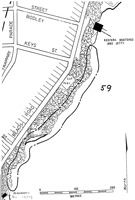 Site 59, Keefers Boatshed area, fossil sites |

© State of Victoria (Agriculture Victoria) 1996 - .

This work, Victorian Resources Online, is licensed under a Creative Commons Attribution 4.0 licence. You are free to re-use the work under that licence, on the condition that you credit the State of Victoria (Agriculture Victoria) as author, indicate if changes were made and comply with the other licence terms.
The licence does not apply to ‘branding’ or some ‘images or photographs’ that may be owned by third parties. We ask you to seek prior approval to use images using the VRO feedback form. Access to higher quality images can also be provided on request.
This page was last updated on .