
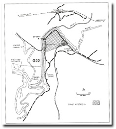
G22 - Healesville Gorge - Outcrop, Levees and Crevasse
|
This information has been developed from the publications:
|
| Location: | AMG Ref: 655300. 500 metres south of the Healesville railway tunnel. | 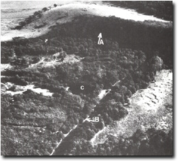 Humevale Formation outcrop at (A) in river bluff and porphyry dyke in river bank at (B). The small lake at (C) is in an old sand quarry. |
Access: | From Yarra Glen - Healesville Road. | |
Geology: | Outcrops of quartz porphyry associated with the Tarrawarra ring dyke system occur on the south bank of the Yarra River. Siltstone of the Humevale Formation is seen in the high bluff at outcrop A. | |
Geomorphology: | The Yarra floodplain narrows at this site where it crosses the ridge extending north from the Warramate Hills. On leaving this narrow sector, the Yarra is flanked by natural sandy levee banks as it emerges onto the extensive Yarra flats. Remnants of an entire earlier channel can be traced on the northern margin of these flats but the river now occupies the southern side of the floodplain. A faint reticulate channel system can be seen on aerial photographs and is the only flood crevasse identified in this study. | |
The small lake adjacent to the channel is in the base of an old sand quarry and is fed by groundwater. | ||
Significance: | Local. The site marks the eastern edge of the Yarra flats and displays outcrop of the basement rocks that bound the floodplain. The levee bank sector is more distinctive than elsewhere in the study area and includes traces of the flood crevasses. | |
Management: | Class 2. The outcrops need no special protection but the levee banks and crevasse could be obscured by sand extraction which should not be permitted. The area from which sand is currently being taken could continue to provide this resource without detracting from the significance of the adjacent areas. | |
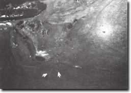 Old flood crevases (arrowed) from abandoned channel at Site G22 | 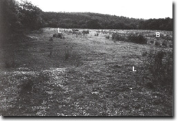 Levee bank (L-L), and backswamp (B) at G22. |

© State of Victoria (Agriculture Victoria) 1996 - .

This work, Victorian Resources Online, is licensed under a Creative Commons Attribution 4.0 licence. You are free to re-use the work under that licence, on the condition that you credit the State of Victoria (Agriculture Victoria) as author, indicate if changes were made and comply with the other licence terms.
The licence does not apply to ‘branding’ or some ‘images or photographs’ that may be owned by third parties. We ask you to seek prior approval to use images using the VRO feedback form. Access to higher quality images can also be provided on request.
This page was last updated on .