
G21 - Flood Chute - Igneous Outcrop
|
This information has been developed from the publications:
|
| Location: | AMG Ref: 638293. | |
Access: | Maddens Lane. | |
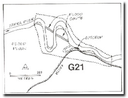
Geology/Geomorphology: | Two small meander loops are crossed by flood chutes which will probably enlarge to form cut-offs. Upstream the channel follows the bluff marking the southern edge of the floodplain and erosion has exposed a Devonian intrusive rock interpreted as a quartz porphyry dyke by Garratt (1973). This intrusion is part of a faulted ring dyke complex. The course of the Yarra River from this point downstream to Tarrawarra follows an alignment determined by the trend of this fault. | |
Significance: | Local. Flood chutes are not common on the Yarra Valley meanders. The site includes one of the few outcrops of the ring dyke material. | |
Management: | Class 1. No diversion or alteration to the flood chute should be permitted. | |
Flood Chute

© State of Victoria (Agriculture Victoria) 1996 - .

This work, Victorian Resources Online, is licensed under a Creative Commons Attribution 4.0 licence. You are free to re-use the work under that licence, on the condition that you credit the State of Victoria (Agriculture Victoria) as author, indicate if changes were made and comply with the other licence terms.
The licence does not apply to ‘branding’ or some ‘images or photographs’ that may be owned by third parties. We ask you to seek prior approval to use images using the VRO feedback form. Access to higher quality images can also be provided on request.
This page was last updated on .