
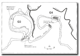
G3 - Watsons Creek - Abandoned High Level Meander
|
This information has been developed from the publications:
|
| Location: | AMG Ref: 468253. | 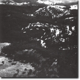 Abandoned meander of the Yarra River (broken line) at Watson's Creek. |
Access: | Henley Road and Oxley Road (Private Land). | |
Geology: | Alluvium (Quaternary) and Anderson Creek Formation siltstone (Silurian). | |
Geomorphology: | The lower section of Watsons Creek occupies a broad U-shaped meander before joining the Yarra River. The dimensions of the meander are more accordant with the geometry of the Yarra River rather than Watsons Creek and it is likely that the bend represents an abandoned reach of the Yarra. | |
The narrow divide forming the neck of the former meander is a strike ridge of resistant siltstone that has been breached by downcutting of the river. The river crosses a series of rapids and low cascades at the site of this breached divide. | ||
The river sediments in the old meander have been incised by Watsons Creek on the western side of the loop and by a small bully on the east. | ||
Significance: | State. This is a very clear example of a forum unique in the study area. The geometry of the abandoned feature is almost identical tot he conspicuous active meander bend of the Yarra immediately to the east of the site. No reference has been made to this site in earlier papers on the Warrandyte gorge area (Jutson, 1911; Hills; 1934) although its existence is of importance in determining the nature of incision by the Yarra into this uplifted fault block. | |
Management: | Class 2. The present intensity of land use is adequate to allow the site features to be readily examined. Higher housing and road intensity would mask the major geomorphic characteristics, especially on the gentle slopes on the east and north. | |
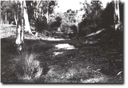 Eastern arm of the abandoned meander at Watson's Creek. |

© State of Victoria (Agriculture Victoria) 1996 - .

This work, Victorian Resources Online, is licensed under a Creative Commons Attribution 4.0 licence. You are free to re-use the work under that licence, on the condition that you credit the State of Victoria (Agriculture Victoria) as author, indicate if changes were made and comply with the other licence terms.
The licence does not apply to ‘branding’ or some ‘images or photographs’ that may be owned by third parties. We ask you to seek prior approval to use images using the VRO feedback form. Access to higher quality images can also be provided on request.
This page was last updated on .