
2.1.1 Dissected Western Uplands associated with Palaeozoic sedimentary and metamorphic rocks
|
In general, the landscapes of the Palaeozoic sedimentary rocks are characterised by undulating low hills dissected by a dendritic drainage pattern that forms the upper catchments of the Moorabool River, Leigh River and Woady Yaloak River drainage systems. The primary drainage trends are parallel to the strike of the bedrock strata and the secondary drainage is controlled by geological boundaries (i.e. lithological boundaries) and rock structures (i.e. faults, joints). The sedimentary rocks generally form the drainage divide along the northern eastern boundary of the CCMA region and rise to a high point of 740 m north of Barkstead. | 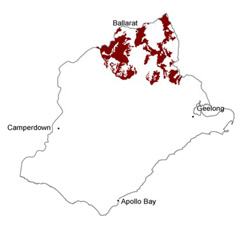 |
Soil-landform unit | Original unit ID | Unit description | Area (km2) |
74 | Steep hills and scarp (Lal Lal) | 27 | |
10 | Rolling low hills and ridges (e.g. Ross Creek) | 472 | |
10a | Rolling hills (e.g. Barkstead) | 48 | |
11 | Undulating hills and ridges (Ballarat) | 94 | |
74 | Steep hills (Lal Lal) | 35 | |
244 | Rolling hills (Brisbane Ranges) | 60 | |
9 | Undulating low hills (Haddon) | 30 | |
51 | Undulating low hills (Bamganie) | 15 | |
8a | Undulating rises (Bunding) | 114 | |
74 | Undulating plains and rises (Lal Lal) | 14 | |
239 | Undulating rises (Meredith) | 36 | |
246 | Undulating rises (Sheoaks) | 13 | |
243 | Gently undulating plain (north of Gordon) | 21 | |
242 | Undulating hills and ridges (north of Meredith) | 20 |
© State of Victoria (Agriculture Victoria) 1996 - .

This work, Victorian Resources Online, is licensed under a Creative Commons Attribution 4.0 licence. You are free to re-use the work under that licence, on the condition that you credit the State of Victoria (Agriculture Victoria) as author, indicate if changes were made and comply with the other licence terms.
The licence does not apply to ‘branding’ or some ‘images or photographs’ that may be owned by third parties. We ask you to seek prior approval to use images using the VRO feedback form. Access to higher quality images can also be provided on request.
This page was last updated on .