
Soil/Landform Unit 14
Landform Unit Description
Page top
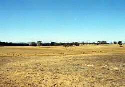
 These gently undulating sedimentary plains support grazing with minor cropping |
0.15% of CMA region North of Meredith are gently undulating rises that are derived from many geological sources including Neogene sands, Quaternary basalt and alluvium, and Ordovician marine shale and sandstone. These gentle rises comprise long gentle slopes, drainage depressions and broad ridges/crests. As part of the Western Uplands, basalt plains to the north and west, and entrenched valley slopes and floors to the east surround this unit. Vegetation of these gentle rises is scarce with less than 0.5% Plains Grassy Woodland as the only major vegetation class. The land supports cropping and grazing as its principal land uses. The main hazards to agricultural land use are sheet and rill erosion, gully erosion, low inherent fertility and low water holding capacity and leaching of nutrients. | 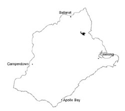 |
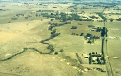
 The gently undulating rises have gentle slopes with broad drainage depressions. Nearly all of this land has been cleared. | 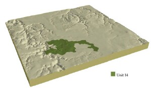 |
| 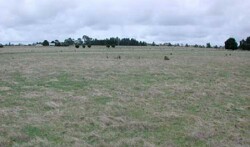 Gently undulating plain leads to a low rise in the distance |
Component | 1 | 2 | 3 | 4 | 5 | 6 |
Proportion of soil-landform unit | 33% | 20% | 25% | 3% | 14% | 5% |
| CLIMATE Rainfall (mm) | Annual: 680 | |||||
| Temperature (oC) | Minimum 7, Maximum 18 | |||||
| Precipitation less than potential evapotranspiration | October-March | |||||
| GEOLOGY Age and lithology | Neogene marine sand, Quaternary basalt and alluvium, Ordovician marine shale and sandstone | |||||
| Geomorphology | ||||||
| LANDUSE | Uncleared: Nature conservation Cleared: Sheep and beef cattle grazing; cropping (cereal) | |||||
| TOPOGRAPHY Landscape | Undulating hills and ridges | |||||
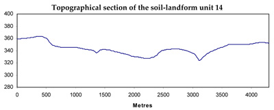
| Elevation range (m) | 318-383 | |||||
| Local relief (m) | 30 | |||||
| Drainage pattern | Dendritic | |||||
| Drainage density (km/km2) | 1.2 | |||||
| Landform | Undulating plain | Depressions | Hills | Rolling plain | Rolling plain | |
| Landform element | Well-drained non-sandy areas | Long gentle upper slopes | Slopes with shallow soil | Crest and steep slopes | Long gentle slope and crest | Drainage line |
| Slope and range (%) | 1 (1-3) | 1 (1-3) | 15 (5-30) | 9 (5-20) | 4 (3-9) | 1 (1-3) |
| Slope shape | Convex | Straight | Straight | Convex | Straight | Concave |
| NATIVE VEGETATION Ecological Vegetation Class | Plains Grassy Woodland (0.4%) | |||||
| Dominant species | Callitris columellaris, E. viminalis, E. obliqua, E. radiata, E. rubida, E. ovata, E. pauciflors | E. ovata, E. viminalis, E. rubida, E. obliqua | E. obliqua, E. viminalis, E. radiata, E. rubida, E. dives | E. obliqua, E. dives, E. radiata, E. rubida | E. obliqua, E. viminalis | E. ovata, E. obliqua |
| SOIL Parent material | Unconsolidated gravel, sand and clay | In situ weathered basalt | In situ weathered sandstone and shale | In situ weathered sandstone and shale | In situ weathered sandstone and shale | Alluvium-clay, silt, sand and gravel |
| Description (Corangamite Soil Group) | Mottled brown, yellow or grey sodic texture contrast soil, coarse structure (36) | Yellow brown or grey texture contrast and yellow gradational soils (25) | Shallow stony brown gradational soils (25) | Red mottled yellow texture contrast soils (25) | ||
| Soil type sites | BD10, CLRA58 | |||||
| Surface texture | Sandy clay loam to loamy sand | Caly loam | Fine sandy loam to clay loam | Gravelly loam | Loamy clay | Clay loam |
| Permeability | Moderate | Moderate to low | Moderate to high | High | Moderate to low | Low to moderate |
| Depth (m) | 2 | 1.5 | 1 | 0.5 | 1 | 2 |
| LAND CHARACTERISTICS, POTENTIAL AND LIMITATIONS | Hardsetting surface soils lead to overland flow and sheet, rill and gully erosion. Dispersive soils and leaching of salts are also features of this soil type. | Hardsetting surfacce soils lead to compaction and are subject to overland flow and sheet erosion. Low permeability leads to seasonal waterlogging. | Overland flow and sheet and rill erosion occurs over steep slopes. Leaching and nutrient decline are often features of this soil type. | Overland flow and sheet and rill erosion occurs over steep slopes. Leaching and nutrient decline are other features of this soil type. | Hardsetting surface soils lead to compaction and are subject to overland flow and gully, sheet and rill erosion. Leaching of salts is another feature of this soil type. | Modeately dispersible and poorly drained soils lead to discharge sites for salinity with accumulation of salts occurring. Hardsetting surface soils may lead to gully erosion. |
© State of Victoria (Agriculture Victoria) 1996 - .

This work, Victorian Resources Online, is licensed under a Creative Commons Attribution 4.0 licence. You are free to re-use the work under that licence, on the condition that you credit the State of Victoria (Agriculture Victoria) as author, indicate if changes were made and comply with the other licence terms.
The licence does not apply to ‘branding’ or some ‘images or photographs’ that may be owned by third parties. We ask you to seek prior approval to use images using the VRO feedback form. Access to higher quality images can also be provided on request.
This page was last updated on .