
Soil/Landform Unit 5
Landform Unit Description
Page top
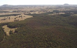 The forests west of Lal Lal are mainly Grassy and Heaty Dry Forests. Nearly 80% of this unit comprises significant remnant vegetation |
0.27% of CMA region | 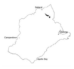 |
|
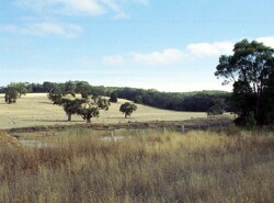 These low hills support grazing by sheep and beef cattle. | 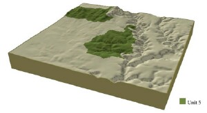 |
 | 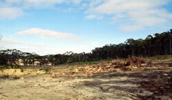 Plantation forestry is a land use of the Ordovician slopes and crests |
Component | 1 | 2 | 3 | 4 |
Proportion of soil-landform unit | 2% | 48% | 3% | 47% |
| CLIMATE Rainfall (mm) | Annual: 720 | |||
| Temperature (oC) | Minimum 7, Maximum 17 | |||
| Precipitation less than potential evapotranspiration | November-March | |||
| GEOLOGY Age and lithology | ||||
| Geomorphology | ||||
| LANDUSE | Uncleared: Nature conservation; water supply Cleared: Sheep and beef cattle grazing; softwood plantations; cropping (cereal); water supply | |||
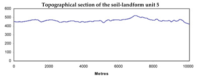
| TOPOGRAPHY Landscape | Steep hills | |||
| Elevation range (m) | 309-538 | |||
| Local relief (m) | 65 | |||
| Drainage pattern | Dendritic | |||
| Drainage density (km/km2) | 3.5 | |||
| Landform | Hills | |||
| Landform element | Moist protected slopes | Dry exposed slopes | Drainage lines | Crests |
| Slope and range (%) | 15 (10-32) | 15 (10-32) | 3 (1-5) | 3 (1-6) |
| Slope shape | Straight | Straight | Concave | Convex |
| NATIVE VEGETATION Ecological Vegetation Class | Grassy Dry Forest (25.7%, Heathy Dry Forest (22.3%), Valley Grassy Forest (13.6%); Plains Grassy Woodland (5.9%); Herb-rich Foothill Forest (2.4%); other (0.9%) | |||
| Dominant species | E. obliqua, E. ovata, E. radiata, E. viminalis | E. obliqua, E. dives, E. radiata, E. viminalis | E. ovata, E. radiata, E. viminalis | E. obliqua, E. dives, E. radiata, E. viminalis |
| SOIL Parent material | In situ weathered sandstone and shale | In situ weathered sandstone and shale | Alluvium, clay, silt, sand, gravel | In situ weathered sandstone and shale |
| Description (Corangamite Soil Group) | Black gradational soil - variable (34) | |||
| Soil type sites | ||||
| Surface texture | Fine sandy loam | Fine sandy loam | Clay loam | Gravelly loam |
| Permeability | High | High | Moderate to low | High |
| Depth (m) | 1 | 2 | >1 | 0.5 |
| LAND CHARACTERISTICS, POTENTIAL AND LIMITATIONS | Steep slopes and hardsetting surfaces contribute to overland flow and sheet and rill erosion. Soil compaction also a limiation when soils are waterlogged. | Steep slopes and hardsetting surfaces contribute to overland flow and sheet and rill erosion. Soil compaction also a limitation when soils are waterlogged. | Moderate permeability soils with hardsetting surfaces. Subsoils are dispersible. Overland flow and subsurface flow compound waterlogging and gully erosion. Soil compaction also a limitation when soils are waterlogged. | Moderate slopes with hardsetting surfaces. Overland flow known to increase sheet and rill erosion. Soil compaction also a limitation when soils are waterlogged. |
© State of Victoria (Agriculture Victoria) 1996 - .

This work, Victorian Resources Online, is licensed under a Creative Commons Attribution 4.0 licence. You are free to re-use the work under that licence, on the condition that you credit the State of Victoria (Agriculture Victoria) as author, indicate if changes were made and comply with the other licence terms.
The licence does not apply to ‘branding’ or some ‘images or photographs’ that may be owned by third parties. We ask you to seek prior approval to use images using the VRO feedback form. Access to higher quality images can also be provided on request.
This page was last updated on .