
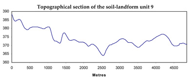
Soil/Landform Unit 9
Landform Unit Description
Page top
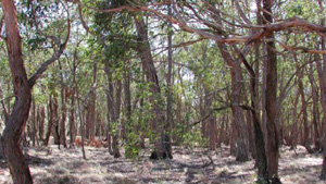
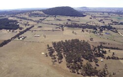 The vegetated capping in the foreground represents part of the Neogene sediments of this unit |
0.86% of CMA region This unit of plains and rises is underlain by Palaeozoic sedimentary rock within the dissected Western Uplands. This unit has a number of occurrences in the uplands, most are fairly large in area. This unit is part of an undulating plain and rise catena formed on older (Palaeozoic) sediments which also has some younger sedimentary (Neogene) capping (Units 22 and 26). The soils are acid and neutral mottled brown and yellow texture contrast soils (Kurosols and Chromosols) which may be sodic (Sodosols), especially where drainage is restricted. Poor aggregate stability and surface soil structure, as well as texture contrast characteristics, make this unit susceptible to sheet, rill and gully erosion, local waterlogging, and soil structural concerns (decline and compaction). Land use is a mixture of extensive grazing, forestry and native vegetation. |  |
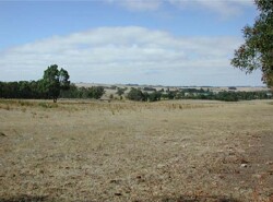 Cleared land is mainly used fro grazing and cereal cropping | 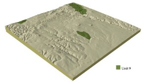 |
|  Remnant vegetation stand south of Clarendon |
Component | 1 | 2 | 3 | 4 | 5 |
Proportion of soil-landform unit | 7% | 80% | 3% | 9% | 1% |
| CLIMATE Rainfall (mm) | Annual: 720 | ||||
| Temperature (oC) | Minimum 7, Maximum 18 | ||||
| Precipitation less than potential evapotranspiration | October-March | ||||
| GEOLOGY Age and lithology | |||||
| Geomorphology | |||||
| LANDUSE | Uncleared: Nature conservation; hardwood and softwood plantations Cleared: Sheep and beef cattle grazing; cropping (cereal) | ||||
| TOPOGRAPHY Landscape | Undulating rises | ||||
| Elevation range (m) | 235-557 | ||||
| Local relief (m) | 10-30 | ||||
| Drainage pattern | Dendritic | ||||
| Drainage density (km/km2) | 3.9 | ||||
| Landform | Rolling plains | Major terraces | Minor terraces | ||
| Landform element | Crest | Long gentle slope | Drainage line | ||
| Slope and range (%) | 1 (1-3) | 5 (3-9) | 1 (1-3) | 1 (1-2) | 1 (1-2) |
| Slope shape | Convex | Straight | Concave | Straight | Straight |
| NATIVE VEGETATION Ecological Vegetation Class | Heathy Dry Forest (6.1%), Grassy Dry Forest (5.4%), Plains Grassy Woodland (4.5%) | ||||
| Dominant species | E. obliqua, E. radiata | E. obliqua, E. viminalis | E. ovata, E. obliqua | E. viminalis, E. radiata | E. viminalis, E. radiata |
| SOIL Parent material | In situ weathered rock | In situ weathered rock | Alluvial clay, silt, sand and gravel | Unconsolidated gravel, sand, silt and clay | Unconsolidated gravel, sand, silt and clay |
| Description (Corangamite Soil Group) | Shallow stony red gradational soil (25) | Mottled brown, grey, yellow and red gradational soil (34) | Yellow brown texture contrast soil, coarse structure (33) | ||
| Soil type sites | |||||
| Surface texture | Gravelly loam | Clay loam | Clay loam | Fine sandy loam | Medium sandy clay loam |
| Permeability | High | Moderate to low | Low to moderate | Moderate to low | Moderate to low |
| Depth (m) | 0.6 | 1 | 2 | 2 | 2 |
| LAND CHARACTERISTICS, POTENTIAL AND LIMITATIONS | Hardsetting surfaces are prone to overland flow and sheet and rill erosion. Subsoils are dispersible, while surface soil often experiences leaching of salts and compaction. | Hardsetting surfaces are prone to overland flow and sheet and rill erosion. Subsoils are dispersible, while surface soil often experiences leaching of salts and compaction. | Moderate dispersible soils with poor site drained. Hardsetting surfaces cause overland flow and gully erosion. In these gullies salts accumulate. | Low-lying areas receiving drainage are seasonally waterlogged. Overland flow and stream flow contribute to streambank and gully erosion. | Low permeability soils with hardsetting surfaces. Weak surface stuctures and overland flow lead to movement of salts, streambank and gully erosion. Subsurface flow and waterlogging also contribute to compaction. |
© State of Victoria (Agriculture Victoria) 1996 - .

This work, Victorian Resources Online, is licensed under a Creative Commons Attribution 4.0 licence. You are free to re-use the work under that licence, on the condition that you credit the State of Victoria (Agriculture Victoria) as author, indicate if changes were made and comply with the other licence terms.
The licence does not apply to ‘branding’ or some ‘images or photographs’ that may be owned by third parties. We ask you to seek prior approval to use images using the VRO feedback form. Access to higher quality images can also be provided on request.
This page was last updated on .