
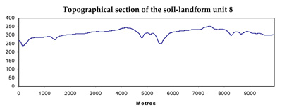
Soil/Landform Unit 8
Landform Unit Description
Page top
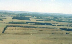 Looking north towards the Bamganie State Forest |
0.23% of CMA region The undulating low hills in the area of the Bamganie State Forest near Meredith are composed of Ordovician marine sandstone and shale with Neogene fluvio-marine sands. The hillslopes support a wide range of vegetation classes including Grassy Dry Forest, Creekline Herb-rich Woodland and Valley Grassy Forest. Dominant species are Eucalyptus obliqua, E. dives, E. radiata and E. viminalis. The low fertility and the low water holding capacity of the soils have discouraged further clearing except on some of the gentler, lower slopes that support native pastures. Soils include an association of sandy mottled texture contrast soils with structured or massive subsoils that occur on the hillslopes with sandy equivalents occurring on upper slopes. These soils can be prone to gully erosion, which is minor to moderate in severity in some cleared areas. |  |
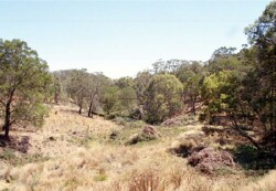 Soils of the gullies and slopes can be quite sandy and of some depth. The presence of bracken fern highlights the light sandy soils of this unit | 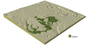 |
| 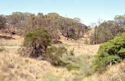 Gully erosion is of minor to moderate severity across this unit. Dispersible subsoils are susceptible is exposed. |
Component | 1 | 2 | 3 | 4 | 5 | 6 | 7 | 8 |
Proportion of soil-landform unit | 1% | 30% | 25% | 5% | 4% | 15% | 15% | 5% |
| CLIMATE Rainfall (mm) | Annual: 670 | |||||||
| Temperature (oC) | Minimum 8; Maximum 18 | |||||||
| Precipitation less than potential evapotranspiration | October-March | |||||||
| GEOLOGY Age and lithology | Ordovician marine slates and sandstone | Neogene gravels, sands and clays | ||||||
| Geomorphology | ||||||||
| LANDUSE | Uncleared: Nature conservation; firewood and sawlogs Cleared: Grazing; gravel extraction; mining | |||||||
| TOPOGRAPHY Landscape | Undulating hills | |||||||
| Elevation range (m) | 180-370 | |||||||
| Local relief (m) | 3-65 | |||||||
| Drainage pattern | Dendritic | |||||||
| Drainage density (km/km2) | 3.5 | |||||||
| Landform | Hills | Depressions | Ralling plains | Undulating plains | Level plains | |||
| Landform element | Moist protected slopes | Dry exposed slopes | Crests | Drainage line | Crests | Long gentle slopes | Well-drained non-sandy areas | Poorly drained non-sandy areas |
| Slope and range (%) | 15 | 15 | 3 | 3 | 1-3 | 3-9 | 1-3 | 0-2 |
| Slope shape | Straight | Straight | Convex | Concave | Convex | Straight | Convex | Flat |
| NATIVE VEGETATION Ecological Vegetation Class | Grassy Dry Forest (13.5%); Creekline Herb-rich Woodland (3.4%); Valley Grassy Forest (1.9%) | |||||||
| Dominant species | E. obliqua, E. dives, E. radiata, E. viminalis | E. obliqua, E. dives, E. radiata, E. viminalis | E. ovata, E. radiata, E. viminalis, E. obliqua | E. obliqua, E. radiata | E. obliqua, E. viminalis | Callitris columellaris E. viminalis, E. obliqua E. raidata, E. rubida E. ovata, E. pauciflora | E. ovata | |
| SOIL Parent material | In situ weathered sandstone and shale | In situ weathered sandstone and shale | In situ weathered sandstone and shale | Alluviu, clay, silt, sand, gravel | In situ weathered sandstone and shale | In situ weathered sandstone and shale | Unconsolidated gravel, sand and clay | Unconsolidated gravel, sand and clay |
| Description (Corangamite Soil Group) | Red mottled brown, grey or yellow gradational or texture contrast soils, fine structure (25) | Shallow stony red and yellow gradational soil (25) | Black gradational (variable) and mottled yellow/red gradational soil (34) | Shallow stony red gradational soil (25) | Red mottled yellow texture contrast soil (26) | Red mottled, brown, grey or yellow texture contrast soil, fine structure (13) | Bronw, grey or yellow sodic texture contrast soil, coarse structure (14) | |
| Soil type sites | ||||||||
| Surface texture | Fine sandy loam | Fine sandy loam | Gravelly loam | Clay loam | Gravelly loam | Loamy clay | Sandy clay loam to loamy sand | Clay loam |
| Permeability | High | High | High | Moderate to low | High | Moderate to low | Moderate | Low |
| Depth (m) | 1 | 2 | 0.5 | 1.5-2.5 | 0.6 | 1 | 2 | 2 |
| LAND CHARACTERISTICS, POTENTIAL AND LIMITATIONS | Hardsetting surface soils on steep slopes are subject to overland flow and sheet and rill erosion. | Harsetting surface soils can lead to compaction and are subject to overland flow and sheet and rill erosion on steep slopes. | Hardsetting surface soils can lead to compaction and are subject to overland flow and sheet and rill erosion on moderate slopes. | Organic surface soils grading to deep medium or heavy texture soils with vertic properties. | High silt content leading to erosion prone soils. Stongly acidic and low nutrient availability with generally shallow organic surface soils. | High silt conent with sodic subsoils can lead to erosion prone soils. Strongly acidic and low nutrient availability with generally shallow organic surface soils. | Presence of buckshot on top of the subsoil is a common feature. Sandy upper soil but subsoils of low permeability. | Presence of buckshot on top of the subsoil is a common feature. Sandy upper soil but strongly sodic subsoils of low permeability. Harsetting surfaces, surface compaction and overland flow lead to sheet erosion. |
© State of Victoria (Agriculture Victoria) 1996 - .

This work, Victorian Resources Online, is licensed under a Creative Commons Attribution 4.0 licence. You are free to re-use the work under that licence, on the condition that you credit the State of Victoria (Agriculture Victoria) as author, indicate if changes were made and comply with the other licence terms.
The licence does not apply to ‘branding’ or some ‘images or photographs’ that may be owned by third parties. We ask you to seek prior approval to use images using the VRO feedback form. Access to higher quality images can also be provided on request.
This page was last updated on .