
Soil/Landform Unit 13
Landform Unit Description
Page top
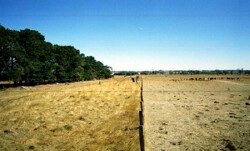
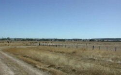 Gently undulating plains north of Gordon have hardsetting surfaces and low permeabilities that lead to overland flow and waterlogging. Recent softwood planting have occurred on these texture contrast soils |
0.16% of CMA region The gently undulating plains north of Gordon are derived from sedimentary sources including Quaternary fluvial and volcaniclastic sediments, Neogene marine sands and Ordovician marine shale and sandstone. Crop yields and pasture production have been limited due to the hardsetting nature of the soils and poor permeability aiding waterlogging. Recent softwood plantations beside the Western Highway have been able to benefit from these deep soils. Vegetation comprises Plains Grassy Woodland, Creekline Herb-rich Woodland and Herb-rich Foothill Forest. These stands of vegetation are significant reserves across the Western Uplands. The gentle plains consist of neutral mottled texture contrast soils with minor occurrences of acidic equivalents. Red mottled texture contrast soils are located in areas of better drainage (slightly elevated). Waterlogging, soil compaction and erosion are limiting factors of these soils that require careful monitoring in land management. |  |
 Near level plains looking towards the Western Highway north of Gordon. Waterlogging of these soils is common in wet. | 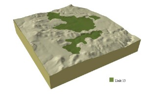 |
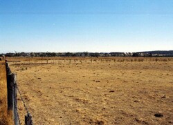
|  Land management of these soils is often reflected in ground cover. Ground coverage is vital to avoid degradation of these soils |
Component | 1 | 2 | 3 | 4 | 5 | 6 |
Proportion of soil-landform unit | 36% | 23% | 17% | 16% | 4% | 4% |
| CLIMATE Rainfall (mm) | Annual: 790 | |||||
| Temperature (oC) | Minimum 7, Maximum 17 | |||||
| Precipitation less than potential evapotranspiration | November-March | |||||
| GEOLOGY Age and lithology | Quaternary fluvial sediments and basalt, Neogene marine sand | Ordovician marine shale and sandstone | ||||
| Geomorphology | ||||||
| LANDUSE | Uncleared: Nature conservation; water supply Cleared: Sheep and beef cattle grazing; cropping (cereal); softwood plantations | |||||
| TOPOGRAPHY Landscape | Gently undulating plains | |||||
| Elevation range (m) | 499-583 | |||||
| Local relief (m) | 3 | |||||
| Drainage pattern | Dendritic | |||||
| Drainage density (km/km2) | 2.9 | |||||
| Landform | Undulating plain | Drainage depression and terraces | Slightly dissected plains | Rolling plain | Hill | |
| Landform element | Well-drained non-sandy areas | Long gentle upper slopes | Long gentle slope | Dry exposed slopes | Crest | |
| Slope and range (%) | 2 (1-3) | 1 (1-2) | 1 (1-3) | 5 (3-9) | 15 (10-30) | 3 (1-6) |
| Slope shape | Convex | Straight | Straight | Straight | Straight | Convex |
| NATIVE VEGETATION Ecological Vegetation Class | Plains Grassy Woodland (3.1%); Creekline Herb-rich Woodland (2.2%) | Herb-rich Foothill Forest (2.3%) | ||||
| Dominant species | E. viminalis, E. radiata | E. ovata, E. viminalis, E. rubida, E. obliqua | E. obliqua, E. viminalis | E. obliqua, E. dives, E. radiata, E. viminalis | E. obliqua, E. dives, E. radiata, E. viminalis | |
| SOIL Parent material | Unconsolidated gravel, sand and clay | Unconsolidated gravel, sand, silt and clay | In situ weathered rock | In situ weathered rock | In situ weathered rock | In situ weathered rock |
| Description (Corangamite Soil Group) | Red mottled, brown, grey or yellow texture contrast soil, fine structure (13) | Dark brown soil - variable (17) | Mottled brown, grey or yellow sodic texture contrast soil, coarse structure (14) | Red mottled brown, grey or yellow texture contrast soil (13) | Red mottled brown, grey or yellow gradational or texture contrast soils, fine structure (26) | Shallow stony red and brown grey or yellow gradational soil (25) |
| Soil type sites | ||||||
| Surface texture | Sandy clay loam to loamy sand | Fine sandy clay loam | Clay loam | Loamy clay | Fine sandy loam | Gravelly loam |
| Permeability | Moderate | Moderate to low | Moderate to low | Moderate to low | High | High |
| Depth (m) | 2 | 3 | 1.5 | 1 | 2 | 0.5 |
| LAND CHARACTERISTICS, POTENTIAL AND LIMITATIONS | Hardsetting surfaces, dispersible subsoils and permeability results in leaching of salts and salt expression at the surface. Overland flow and sheet and rill erosion reflect these hardsetting surfaces. | Low-lying areas are prone to seasonal waterlogging and discharge as salinity. Overland flow and sheet and rill erosion reflect these hardsetting surfaces. | Hardsetting surfaces, dispersible subsoils, and permeability results in leaching of salts and salt expression at the surface. Overland flow and sheet and rill erosion reflect these hardsetting surfaces. | Hardsetting surfaces, dispersible suboils, and permeability results in leaching of salts and salt expression at the surface. Overland flow and sheet and rill erosion reflect these hardsetting surfaces. | Steep slopes are often responsible for overland flow and sheet and rill erosion. These also reflect the hardsetting surfaces. Soil compaction can benefit from addition of organic matter. | Steep slopes are often responsible for overland flow and sheet and rill erison. These also reflect the hardsetting surfaces. Soil compaction can benefit from addition of organic matter. |
© State of Victoria (Agriculture Victoria) 1996 - .

This work, Victorian Resources Online, is licensed under a Creative Commons Attribution 4.0 licence. You are free to re-use the work under that licence, on the condition that you credit the State of Victoria (Agriculture Victoria) as author, indicate if changes were made and comply with the other licence terms.
The licence does not apply to ‘branding’ or some ‘images or photographs’ that may be owned by third parties. We ask you to seek prior approval to use images using the VRO feedback form. Access to higher quality images can also be provided on request.
This page was last updated on .