
Soil/Landform Unit 12
Landform Unit Description
Page top
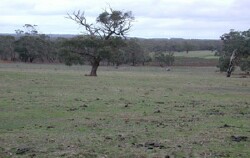 Cleared land at the 'She Oaks' east of Steiglitz |
0.10% of CMA region Undulating rises on Neogene marine sediments occur in the Sheoaks-Steiglitz area in the east of the Corangamite catchment. As part of the Midlands of the Western Uplands, a wide variety of vegetation classes are found across this unit including Lowland Forest, Grassy Dry Forest, Heathy Dry Forest and Valley Grassy Forest. The dominant species include Eucalyptus obliqua, E. dives, E. radiata, E. viminalis and E. ovata. The sedimentary sands, silt and clay have a low inherent fertility and low water holding capacity. Land use is mainly grazing. Soils include sandy mottled texture contrast soils with massive subsoils. Structured subsoil equivalents may occur and there are minor occurrences of neutral mottled texture contrast soils. These soils tend to have shallow topsoils that are prone to sheet erosion, while the deeper soils in the drainage depression suffer from gully erosion and soil salting. |  |
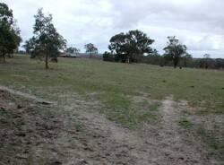 Cleared land gives way to pale loose sandy soils |  |
| 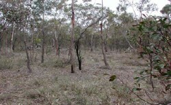 Remnant vegetation consists of brown stringybark, messmate and wattles |
Component | 1 | 2 | 3 | 4 | 5 |
Proportion of soil-landform unit | 60% | 13% | 12% | 7% | 8% |
| CLIMATE Rainfall (mm) | Annual: 660 | ||||
| Temperature (oC) | Minimum 8, Maximum 18 | ||||
| Precipitation less than potential evapotranspiration | October-March | ||||
| GEOLOGY Age and lithology | |||||
| Geomorphology | |||||
| LANDUSE | Uncleared: Nature conservation; water supply Cleared: Sheet and cattle grazing; cropping (cereal) | ||||
| TOPOGRAPHY Landscape | Undulating rises | ||||
| Elevation range (m) | 164-364 | ||||
| Local relief (m) | 3 | ||||
| Drainage pattern | Dendritic | ||||
| Drainage density (km/km2) | 2.3 | ||||
| Landform | Undulating plain | Flat plain | Drainage lines | Hill | |
| Landform element | Well drained non-sandy areas | Poorly drained non-sandy areas | Low lying areas | Dry exposed slopes | Crest |
| Slope and range (%) | 2 (1-3) | 0 (0-2) | 1 (1-3) | 15 (10-35) | 3 (1-6) |
| Slope shape | Convex | Flat | Concave | Straight | Convex |
| NATIVE VEGETATION Ecological Vegetation Class | Lowland Forest (20.4%); Grassy Dry Forest (13.6%); Heathy Dry Forest (4.8%); Valley Grassy Forest (2.1%); Plains Grassy Woodland (0.9%) | ||||
| Dominant species | E. ovata | E. ovata | E. ovata | E. obliqua, E. dives, E. radiata, E. viminalis | E. obliqua, E. dives, E. radiata, E. viminalis |
| SOIL Parent material | Unconsolidated gravel, sand and clay | Unconsolidated gravel, sand and caly | Unconsolidated gravel, sand and clay | In situ weathered sandstone and shale | In situ weathered sandstone and shale |
| Description (Corangamite Soil Group) | Red mottled brown, grey or yellow texture contrast soil, fine structure (15) | Brown, grey or yellow sodic texture soil, coarse structure (14) | Mottled brown, grey or yellow texture contrast soil (13) | Red mottled brown, grey or yellow gradational or texture contrast soils, fine structure (25) | Shallow stony red and brown, grey or yellow gradational soil (25) |
| Soil type sites | |||||
| Surface texture | Sandy clay loam to loamy sand | Clay loam | Clay loam, sandy clay loam | Fine sandy loam | Gravelly loam |
| Permeability | Moderate | Low | Moderate | High | High |
| Depth (m) | 2 | 2 | 2 | 2 | 0.5 |
| LAND CHARACTERISTICS, POTENTIAL AND LIMITATIONS | Steep slopes and hardsetting surface result in significant over flow. Sheet and rill erosion also occurs from this overland flow. Gully erosion is also common in lower depressions. | Steep slopes and hardsetting surfaces result in significant overland flow. Sheet and rill erosion also occurs from this overland flow. Soil compaction is also a limitation for soils with shallow topsoils. | Moderate permeability subsoils and hardsetting surface result in significant flow. Sheet and rill erosion also occurs from this overland flow. Soil compaction is also a limitation for soils with shallow topsoils. Gully erosion is also common in lower depressions. | Steep slopes and harsetting surfaces result in significant overland flow. Sheet and rill erosion also occurs from this overland flow. Soil compaction is also a limitation for soils with shallow topsoils. | Moderate slopes and hardsetting surfaces result in significant overland flow. Sheet and rill erosion also occurs from this overland flow. Soil compaction is also a limitation for soils with shallow topsoils. |
© State of Victoria (Agriculture Victoria) 1996 - .

This work, Victorian Resources Online, is licensed under a Creative Commons Attribution 4.0 licence. You are free to re-use the work under that licence, on the condition that you credit the State of Victoria (Agriculture Victoria) as author, indicate if changes were made and comply with the other licence terms.
The licence does not apply to ‘branding’ or some ‘images or photographs’ that may be owned by third parties. We ask you to seek prior approval to use images using the VRO feedback form. Access to higher quality images can also be provided on request.
This page was last updated on .