
Soil/Landform Unit 7
Landform Unit Description
Page top
 Low hills north of Haddon |
0.10% of CMA region North-west of Haddon are slopes of low hills situated on the western boundary of the Corangamite catchment. These low hills are primarily derived from Ordovician marine sandstone and shale bedrock with minor Recent clay, sand and gravel, and basalt. As part of the Western Uplands, this unit continues well into the Glenelg-Hopkins catchment. Soils are composed of mottled brown and yellow texture contrast soils (Chromosols and minor Sodosols) that may have surface soils with depths of 80 cm. There are minor occurrences of mottled brown soils with sporadically bleached subsurface horizons in better-drained areas. Native vegetation communities on these low hills include Plains Grassland/Plains Grassy Woodland Mosaic. Land use is mainly grazing for sheep and beef cattle with some cropping on lower slopes. The main hazards to land use are heavy subsoils that are occasionally sodic (causing gully erosion where exposed), sheet and rill erosion, and low subsoil permeabilities (low water holding capacity). Salinity as discharge also occurs within this unit. | 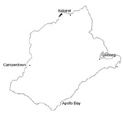 |
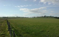
 View looking west-south-west from Smythes Creek towards Haddon | 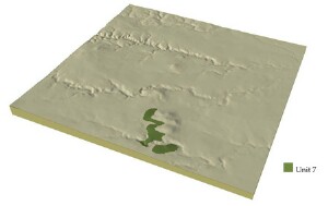 |
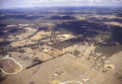
 | 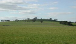 Little remnant vegetation remains on the southern slopes of these hills |
Component | 1 | 2 | 3 | 4 |
Proportion of soil-landform unit | 10% | 35% | 50% | 5% |
| CLIMATE Rainfall (mm) | Annual: 640 | |||
| Temperature (oC) | Minimum 8, Maximum 19 | |||
| Precipitation less than potential evapotranspiration | October-March | |||
| GEOLOGY Age and lithology | Ordovician marine sandstone and shale, recent clay, sand and gravel and minor basalt | |||
| Geomorphology | ||||
| LANDUSE | Uncleared: Nature conservation; water supply Cleared: Sheep and beef cattle grazing; cropping (cereal) | |||
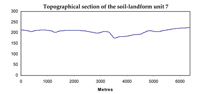
| TOPOGRAPHY Landscape | Undulating low hills | |||
| Elevation range (m) | 150-455 | |||
| Local relief (m) | 40 | |||
| Drainage pattern | Dendritic | |||
| Drainage density (km/km2) | 2.0 | |||
| Landform | Low hills | |||
| Landform element | Crests and ridges | Slopes | Rolling undulating plains | Drainage lines |
| Slope and range (%) | 4 (1-7) | 4 (3-10) | 2 (0-5) | 1 (0-3) |
| Slope shape | Convex | Convex | Convex | Concave |
| NATIVE VEGETATION Ecological Vegetation Class | Plains Grassland/Plains Grassy Woodland Mosaic (9.0%) | |||
| SOIL Parent material | Sedimentary rock | Sedimentary rock | Sedimentary rock and colluvium | Colluvium and alluvium |
| Description (Corangamite Soil Group) | Acid and neutral mottled brown/grey or yellow texture contrast soils (25) | Acid and neutral mottled brown/grey or yellow texture contrast soils (25) | Acid and neutral mottled brown/grey or yellow texture contrast soils (26) | Acid and neutral mottled brown/grey or yellow texture contrast soils (26) |
| Soil type sites | ||||
| Surface texture | Fine sandy loam | Fine sandy loam | Fine sandy loam | Fine sandy loam |
| Permeability | Moderate | Moderate to low | Low to moderate | Low |
| Depth (m) | <1 | <1.5 | <2 | <2, >2 |
| LAND CHARACTERISTICS, POTENTIAL AND LIMITATIONS | Texture contrast, low to moderate water holding capacity and nutrient holding capacity in surface and subsurface soil, moderate to high in subsoil. Rapid site drainage. Hardsetting surface, heavy subsoils with overland flow and leaching of salts common. Susceptibility to sheet and rill erosioon and compaction. | Texture contrast, low to moderate water holding capacity and nutrient holding capacity in surface and subsurface soil, moderate to high subsoil. Rapid site drainage. Hardsetting surface, heavy subsoils, overland flow, leaching of salts. Susceptibility to sheet and rill erosion and compaction. | Texture contrast, low to moderate water holding capacity and nutrient holding capacity in surface and subsurface soil, moderate to high subsoil. Rapid site drainage. Hardsetting surface, heavy subsoils with overland flow and leaching of salts common. Susceptibility to sheet and rill erosion and compaction. | Texture contrast, low to moderate water holding capacity and nutrient holding capacity in surface and subsurface soil, moderate to high subsoil. Rapid site drainage. Hardsetting surface, heavy subsoils with overland flow and leaching of salts common. Susceptibility to sheet and rill erosion and compaction. |
© State of Victoria (Agriculture Victoria) 1996 - .

This work, Victorian Resources Online, is licensed under a Creative Commons Attribution 4.0 licence. You are free to re-use the work under that licence, on the condition that you credit the State of Victoria (Agriculture Victoria) as author, indicate if changes were made and comply with the other licence terms.
The licence does not apply to ‘branding’ or some ‘images or photographs’ that may be owned by third parties. We ask you to seek prior approval to use images using the VRO feedback form. Access to higher quality images can also be provided on request.
This page was last updated on .