
Soil/Landform Unit 10
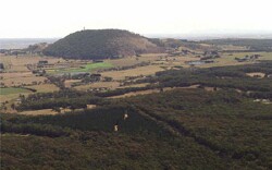 The north-south crest visible in the Lal Lal State Forest indicates the boundary of this unit (towards Mount Buninyong) with the neighbouring Ordovician low hills (largely the Lal Lal State forest) |
0.11% of CMA region Gentle plains and rises associated with Ordovician sandstones and shales are found south-east of Mount Buninyong as part of a sequence of Ordovician landforms extending to Lal Lal Reservoir. This unit within the Western Uplands has a lower level of remnant vegetation then neighbouring Ordovician units (5 and 1). Native vegetation classes of these low hills include Grassy Dry and Herb-rich Foothill Forests as well as Swampy Riparian and Grassy Woodlands. Land use is mainly grazing with minor cropping, however there are some minor hardwood/softwood plantations within this unit. The urban spread from Ballarat and Buninyong is an emerging land use, which should be considered. Soils include red and black strongly structured earth on crests, yellow and brown texture contrast and gradational soils, and minor black and brown texture contrast soils on the slopes and drainage depressions. The main hazards to land use are overland flow causing sheet and rill erosion, and gully erosion where subsoils are exposed. Soils are particularly limited for agricultural land use by their low inherent fertility and water holding capacity. Swamps and saline discharge may also occur within this unit. |  |
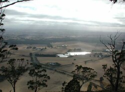 The gentle plains and rises are mainly used for grazing and minor cropping. Residiential development is also increasingly popular | 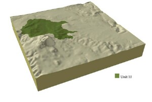 |
| 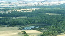 Swamps are located within the gentle plains and rises east of Mount Buninyong |
Component | 1 | 2 | 3 |
Proportion of soil-landform unit | 10% | 85% | 5% |
| CLIMATE Rainfall (mm) | Annual: 1000 | ||
| Temperature (oC) | Minimum 6, Maximum 16 | ||
| Precipitation less than potential evapotranspiration | November-March | ||
| GEOLOGY Age and lithology | |||
| Geomorphology | |||
| LANDUSE | Uncleared: Nature conservation; water supply Cleared: Sheet and beef cattle grazing softwood plantations; cropping (cereal) | ||
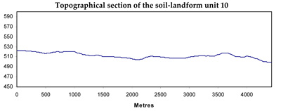
| TOPOGRAPHY Landscape | Undulating plains and rises | ||
| Elevation range (m) | 488-591 | ||
| Local relief (m) | 10 | ||
| Drainage pattern | Dendritic | ||
| Drainage density (km/km2) | 2.2 | ||
| Landform | Undulating plains | ||
| Landform element | Crest | Long gentle slopes | Drainage line |
| Slope and range (%) | 2 (1-3) | 4 (3-9) | 1 (1-3) |
| Slope shape | Convex | Straight | Concave |
| NATIVE VEGETATION Structure | Woodland | Open forest | Open forest |
| Dominant species | E. obliqua, E. radiata | E. obliqua, E. viminalis | E. ovata, E. obliqua |
| SOIL Parent material | In situ weathered sandstone and shale, basalt | In situ sandstone and shale | Alluvial clay, silt, sand and gravel |
| Description (Corangamite Soil Group) | Shallow stony red gradational soil (40) | Mottled yellow and red, brown gradational soil (25) | |
| Soil type sites | |||
| Surface texture | Gravelly loam | Loamy clay | Clay loam |
| Permeability | High | Moderate to low | Low to modeate |
| Depth (m) | 0.6 | 1 | 2 |
| LAND CHARACTERISTICS, POTENTIAL AND LIMITATIONS | Hardsetting surface soils lead to compaction and are subject to overland flow and sheet and rill erosion. Dispersive subsoils and leaching of salts may alos be features of these soil types. | Hardsetting surface soils lead to compaction and are subject to overland flow, gully erosion and sheet and rill erosion. Leaching of salts may also be features of these soil types. | Moderate dispersible and poorly drained soils lead to discharge sites for salinity with accumulation of salts occurring. Hardsetting surface soils may lead to overland flow and gully erosion. |
© State of Victoria (Agriculture Victoria) 1996 - .

This work, Victorian Resources Online, is licensed under a Creative Commons Attribution 4.0 licence. You are free to re-use the work under that licence, on the condition that you credit the State of Victoria (Agriculture Victoria) as author, indicate if changes were made and comply with the other licence terms.
The licence does not apply to ‘branding’ or some ‘images or photographs’ that may be owned by third parties. We ask you to seek prior approval to use images using the VRO feedback form. Access to higher quality images can also be provided on request.
This page was last updated on .