
Soil/Landform Unit 4
Landform Unit Description
Page top
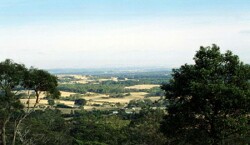
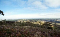 View over Mount Helen towards Ballarat from teh steep slopes of Mount Buninyong |
0.70% of CMA region | 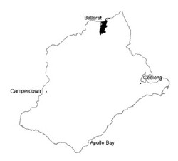 |
|
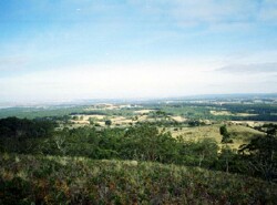 Undulating hills with native vegetation stands. | 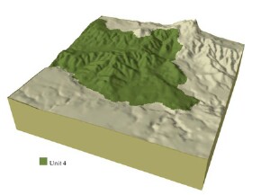 |
 |  Land use is primarily grazing and urban development of Ballarat |
Component | 1 | 2 | 3 | 4 | 5 | 6 |
Proportion of soil-landform unit | 20% | 15% | 35% | 23% | 2% | 5% |
| CLIMATE Rainfall (mm) | Annual: 780 | |||||
| Temperature (oC) | Minimum 7, Maximum 17 | |||||
| Precipitation less than potential evapotranspiration | November-March | |||||
| GEOLOGY Age and lithology | ||||||
| Geomorphology | ||||||
| LANDUSE | Uncleared: Nature conservation; water supply; hardwood plantation; softwood plantation; passive and active recreation Cleared: Beef cattle and sheep grazing; forestry; cropping (cereal); hardwood plantation; softwood plantation | |||||
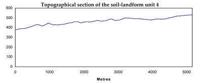
| TOPOGRAPHY Landscape | Undulating hills and ridges | |||||
| Elevation range (m) | 360-630 | |||||
| Local relief (m) | 50 | |||||
| Drainage pattern | Dendritic | |||||
| Drainage density (km/km2) | 3.0 | |||||
| Landform | Hills | Drainage lines | Ridges | |||
| Landform element | Broad crests | Gentle plains and rises | Rolling hills | Moderately steep slopes | Drainage line | Ridge and and ravine |
| Slope and range (%) | 4 (1-7) | 14 (5-37) | 5 (2-9) | 11 (3-15) | 4 (2-9) | 4 (0-11) |
| Slope shape | Convex | Convex | Convex | Straight | Concave | Convex |
| NATIVE VEGETATION Ecological Vegetation Class | Heathy Dry Forest (23.4%); Grassy Dry Forest (4.6%); Valley Grassy Forest (1.8%); Herb-rich Foothill Forest (1.7%) | |||||
| Dominant species | E. obliqua, E. radiata | E. obliqua, E. viminalis | E. obliqua, E. viminalis | E. obliqua, E. dives, E. radiata, E. viminalis | E. ovata, E. radiata, E. viminalis | E. obliqua, E. dives, E. radiata, E. viminalis |
| SOIL Parent material | In situ weathered sandstone and shale | In situ weathered sandstone and shale | In situ weathered sandstone and shale | In situ weathered sandstone and shale | Alluvium, clay, silt, sand, gravel | In situ weathered sandstone and shale |
| Description (Corangamite Soil Group) | Shallow stony red gradational soil (25) | Red mottled, brown, grey or yellow texture contrast soil (25) | Red mottled, brown, grey or yellow texture contrast soil (25) | Red mottled, brown, grey or yellow gradational or texture contrast soils, fine structure (25) | Black gradational (earth) soil, (variable) (34) | Shallow stony red and brown, grey or yellow gradational soil (25) |
| Soil type sites | CLRA54, CLRA58, BD10 | CLRA54, CLRA58, BD10 | ||||
| Surface texture | Gravelly loam | Loamy clay | Loamy clay | Fine sandy loam | Clay loam | Gravelly loam |
| Permeability | High | Moderate to low | Moderate to low | High | Moderate to low | High |
| Depth (m) | 0.6 | 1.5 | 1 | 2 | >1 | 0.5 |
| LAND CHARACTERISTICS, POTENTIAL AND LIMITATIONS | Hardsetting surfaces and low permeability leads to overland flow. This flow often creates sheet and rill erosion with major rainfall events. Gully erosion and leaching of salts also occur. Surface compaction can benefit from controlled traffic. | Hardsetting surfaces and low permeability leads to overland flow. This flow often creates sheet and rill erosion with major rainfall events. Gully erosion and leaching of salts also occur. Surface compaction can benefit from controlled traffic. | Hardsetting surfaces and low permeability leads to overland flow. This often creates sheet and rill erosion with major rainfall events. Gully erosion and leachign of salts also occur. Surface compaction can benefit from controlled traffic. | Steep slopes causing overland flow is likely to cause sheet and rill erosion. Nutrient decline is possible due to shallow and permeable soils. | Moderate permeability soils. Overland flow often creates sheet and rill erosion with major rainfall events. Waterlogging is periodic and gully erosion is most common here. | Moderate permeability soils. Overland flow often creates heet and rill erosion wiht major rainfall events. Waterlogging is periodic and gully erosion is most ocmmon here. |
© State of Victoria (Agriculture Victoria) 1996 - .

This work, Victorian Resources Online, is licensed under a Creative Commons Attribution 4.0 licence. You are free to re-use the work under that licence, on the condition that you credit the State of Victoria (Agriculture Victoria) as author, indicate if changes were made and comply with the other licence terms.
The licence does not apply to ‘branding’ or some ‘images or photographs’ that may be owned by third parties. We ask you to seek prior approval to use images using the VRO feedback form. Access to higher quality images can also be provided on request.
This page was last updated on .