
Soil/Landform Unit 11
Landform Unit Description
Page top
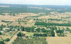 Looking east over the town of Meredith towards the Brisbane Ranges. The forested rises east of Meredith are associated with dissection of the Moorabool River |
0.27% of CMA region The undulating rises in the Meredith area are composed of a veneer of Neogene fluvial gravels, sands and clays over Lower Ordovician marine slate and sandstone. Often these Ordovician sediments are exposed in dissection of this landscape where the Neogene material has been removed. These sedimentary rises have Grassy Dry Forests and Heathy Dry Forests as the dominant vegetation communities. Slopes of the rises are generally gentle, though there can be quite steep slopes and scarps neighbouring the Moorabool River. Land use is predominantly grazing with some cropping. Soils on the slopes consist of neutral and alkaline mottled yellow and brown texture contrast soils with occasional red equivalents. Overland flow is attributed to the hardsetting surfaces of these texture contrast soils and their low subsoil permeability. Salting is also common in the dissections and gullies, along with sheet and rill erosion. This salting occurs especially adjacent to Ordovician sediments. | 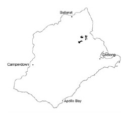 |
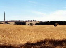 Undulating rises that have been cropped west of Meredith | 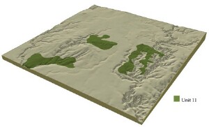 |
| 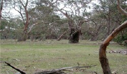 Grassy Dry Forest remnants west of Meredith |
Component | 1 | 2 | 3 | 4 | 5 | 6 | 7 | 8 |
Proportion of soil-landform unit | 35% | 1% | 7% | 7% | 22% | 10% | 3% | 15% |
| CLIMATE Rainfall (mm) | Annual: 680 | |||||||
| Temperature (oC) | Minimum 8, Maximum 18 | |||||||
| Precipitation less than potential evapotranspiration | October-March | |||||||
| GEOLOGY Age and lithology | Neogene fluvial gravels, sands and clays | Ordovician marine slate and sandstone | ||||||
| Geomorphology | ||||||||
| LANDUSE | Uncleared: Nature conservation; water supply; hardwood forestry Cleared: Sheep and beef cattle grazing; gravel extraction; cropping (cereal) | |||||||
| TOPOGRAPHY Landscape | Undulating rises | |||||||
| Elevation range (m) | 151-360 | |||||||
| Local relief (m) | 3 | |||||||
| Drainage pattern | Dendritic | |||||||
| Drainage density (km/km2) | 4.4 | |||||||
| Landform | Undualting plain | Undulating plain | Flat plain | Drainage lines | Undulating plain | Broad ridge | Scarp | |
| Landform element | Well-drained non-sandy areas | Patches of deep sandy soil | Poorly drained non-sandy areas | Low lying areas | Long gentle slope | Crest | Drainage line | Dry exposed slopes |
| Slope and range (%) | 1 (1-3) | 1 (1-3) | 0 (0-2) | 1 (1-3) | 4 (4-6) | 2 (1-3) | 2 (1-3) | 15 (10-25) |
| Slope shape | Convex | Convex | Flat | Concave | Straight | Convex | Concave | Straight |
| NATIVE VEGETATION Ecological Vegetation Class | Grassy Dry Forest (8.4%) | Heathy Dry Forest (1.9%) | ||||||
| Dominant species | Pteridium esulentum, E. viminalis | Pteridium esulentum, E. viminalis | E. ovata | E. ovata | E. viminalis, E. obliqua | E. obliqua, E. radiata | E. ovata, E. obliqua | E. viminalis, E. obliqua, E. dives, E. radiata |
| SOIL Parent material | Unconsolidated gravel, sand and clay | Unconsolidated sand | Unconsolidated gravel, sand and clay | Unconsolidated gravel, sand and clay | In situ sandstone and shale | In situ sandstone and shale | Allvuium-clay, silt, sand and gravel | In situ sandstond and shale |
| Description (Corangamite Soil Group) | Yellow sand soil, uniform texture (16) | Brown, grey or yellow sodic texture contrast soil, coarse structure (14) | Mottled brown, grey or yellow texture contrast (32) | Mottled red and brown, grey or yellow texture contrast soils (26) | Mottled brown, grey or yellow texture contrast soils (25) | Mottled brown, grey or yellow gradational or texture contrast soils, fine structure (25) | ||
| Soil type sites | SW93, SW99 | CLRA57, CLRA58, BD10 | CLRA53, CLRA57 | |||||
| Surface texture | Sandy loam to loamy sand | Sand | Clay loam | Clay loam, sandy clay loam | Clay loam | Loam to clay loam | Clay loam | Silty loam |
| Permeability | Moderate | High | Low | Moderate | Moderate to low | High | Low to moderate | High |
| Depth (m) | 2 | 2 | 2 | 2 | 0.8-1.8 | 0.5-1.0 | 1.5-2.5 | >0.5-1.2 |
| LAND CHARACTERISTICS, POTENTIAL AND LIMITATIONS | Hardsetting surface soils are subject to overland flow, gully erosion and sheet and rill erosion. Dispersive subsoils and leaching of salts may also be features of these soil types. | High leaching potential and low water holding capacity leads to low nutrient holding capacity and fertility decline. | Hardsetting surface soils lead to surface compaction and are subject to overland flow and sheet erosion. Leaching of salts may also be features of these soil types. | Hardsetting surface soils lead to overland flow and sheet and rill erosion and some minor gully erosion. Some accumulation of salts occurs especially when adjacent to Ordovician sediments. | Hardsetting suface soils lead to surface compaction and are subjec to overland flow and minor sheet and rill erosion. Dispersive subsoils and leaching of salts may also occur. | Hardsetting surface soils lead to surface compaction and are subject to over land flow and minor sheet and rill erosion. Dispersive subsoils and leaching of salts may also occur. | Poorly drained soils with hardsetting surfaces. Watertables are seasonally high with periodic waterlogging and soil salinity. Gully erosion may sometimes occur. | Hardsetting surface soils lead to surface compaction and are subject to overland flow and moderate sheet and rill erosion on steep slopes. |
© State of Victoria (Agriculture Victoria) 1996 - .

This work, Victorian Resources Online, is licensed under a Creative Commons Attribution 4.0 licence. You are free to re-use the work under that licence, on the condition that you credit the State of Victoria (Agriculture Victoria) as author, indicate if changes were made and comply with the other licence terms.
The licence does not apply to ‘branding’ or some ‘images or photographs’ that may be owned by third parties. We ask you to seek prior approval to use images using the VRO feedback form. Access to higher quality images can also be provided on request.
This page was last updated on .