
Soil/Landform Unit 6
Landform Unit Description
Page top
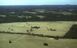 The 80% uncleared forested Brisbane Ranges comrpise most of this unit with a wide range of vegetation communities |
0.45% of CMA region Rolling hills on sedimentary sediments occur as the Brisbane Ranges on the eastern boundary of the Corangamite catchment. A rich diversity of vegetation comprising 80% of this unit include the communities of Heathy Dry Forest, Grassy Dry Forest, Lowland Forest, Valley Grassy Forest, Shrubby Woodland and Creekline Herb-rich Woodland. The dominant species of these vegetation groups are Eucalyptus obliqua, E. ovata, E. radiata and E. viminalis. The steep and rocky nature of the terrain, low fertility and low water holding capacity of the soils have discouraged further clearing, except on some of the gentler, lower slopes that support native pastures. The forest in the past has provided sawn timber, posts and firewood. Soils include an association of acidic mottled texture contrast soils with structured or massive subsoils. These relatively shallow stony soils are prone to sheet erosion, while the deeper soils in the drainage depression suffer from gully erosion and soil salting. |  |
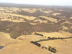 Steeply dissected terrain is often vegetated, however areas are particularly vulnerable to erosion | 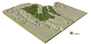 |
 | 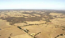 Cleared land is mainly used for grazing |
Component | 1 | 2 | 3 | 4 |
Proportion of soil-landform unit | 2% | 50% | 3% | 45% |
| CLIMATE Rainfall (mm) | Annual: 660 | |||
| Temperature (oC) | Minimum 8, Maximum 8 | |||
| Precipitation less than potential evapotranspiration | October-March | |||
| GEOLOGY Age and lithology | Ordovician marine shale and sandstone, Neogene fluvio-marine clay, sand and gravel | |||
| Geomorphology | ||||
| LANDUSE | Uncleared: Water supply; nature conservation; hardwood; gravel extraction Cleared: Sheep and beef cattle grazing; cropping (cereal); gravel extraction | |||
| TOPOGRAPHY Landscape | Rolling hills | |||
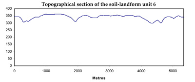
| Elevation range (m) | 130-363 | |||
| Local relief (m) | 65 | |||
| Drainage pattern | Dendritic | |||
| Drainage density (km/km2) | 4.8 | |||
| Landform | Hill | |||
| Landform element | Moist protected slopes | Dry exposed slopes | Drainage line | Crest |
| Slope and range (%) | 15 (10-30) | 15 (10-30) | 3 (1-4) | 3 (1-6) |
| Slope shape | Straight | Straight | Concave | Convex |
| NATIVE VEGETATION Ecological Vegetation Class | Heathy Dry Forest (34.2%), Grassy Dry Forest (24.0%), Lowland Forest (8.2%), Valley Grassy Forest (3.6%), Shrubby Woodland (3.3%), Creekline Herb-rich Woodland (3.0%) | |||
| Dominant species | E. obliqua, E. ovata, E. radiata, E. viminalis | E. obliqua, E. dives, E. radiata, E. viminalis | E. ovata, E. radiata, E. viminalis | E. obliqua, E. dives, E. radiata, E. viminalis |
| SOIL Parent material | In situ weathered sandstone and shale | In situ weathered sandstone and shale | Alluvium, clay, silt, sand, gravel | In situ weathered sandstone and shale, unconsolidated sediments |
| Description (Corangamite Soil Group) | Black gradational soil - variable (34) | Shallow stony red and bronw, grey or yellow gradational soil (25) | ||
| Soil type sites | CLRA1, OTR733 | |||
| Surface texture | Fine sandy loam | Fine sandy loam | Clay loam | Gravelly loam |
| Permeability | High | High | Moderate to low | High |
| Depth (m) | 1 | 2 | >1 | 0.5 |
| LAND CHARACTERISTICS, POTENTIAL AND LIMITATIONS | Steep slopes and hardsetting surfaces result in significant overland flow. Sheet and rill erosion also occur from this overland flow. | Steep slopes and hardsetting surfaces result in significant overland flow. Sheet and rill erosion also occur from this overland flow. Soil compaction is also a limitation for soils with shallow topsoils. | Moderate permeability subsoils and hardsetting surfaces result in significant overland flow. Sheet and rill erosion also occur from this overland flow. Soil compaction is also a limitation for soils with shallow topsoils. | Moderate slopes and hardsetting surfaces result in significant overland flow. Sheet and rill erosion also occur from this overland flow. Soil compaction is also a limitation for soils with shallow topsoils. |
© State of Victoria (Agriculture Victoria) 1996 - .

This work, Victorian Resources Online, is licensed under a Creative Commons Attribution 4.0 licence. You are free to re-use the work under that licence, on the condition that you credit the State of Victoria (Agriculture Victoria) as author, indicate if changes were made and comply with the other licence terms.
The licence does not apply to ‘branding’ or some ‘images or photographs’ that may be owned by third parties. We ask you to seek prior approval to use images using the VRO feedback form. Access to higher quality images can also be provided on request.
This page was last updated on .