
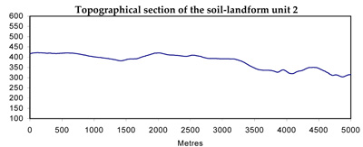
Soil/Landform Unit 2
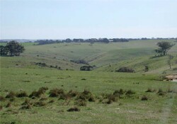
 Scarps and steep slopes are very typical within this landscape |
3.53 % of CMA region | 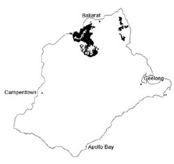 |
|
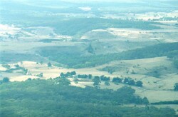
 Upper slopes leading to deeply dissected valleys and drainage depressions | 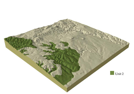 |
 | 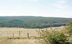 Plantation of Pinus radiata within a native vegetation stand at Garibaldi |
Component | 1 | 2 | 3 | 4 | 5 | 6 |
Proportion of soil-landform unit | 20% | 15% | 35% | 23% | 2% | 5% |
| CLIMATE Rainfall (mm) | Annual: 710 | |||||
| Temperature (oC) | Minimum 7, Maximum 18 | |||||
| Precipitation less than potential evapotranspiration | October-March | |||||
| GEOLOGY Age and lithology | Cambro-Ordovician marine sandstone and shale, minor Quaternary basalt and Neogene clay, sand and gravel. | |||||
| Geomorphology | ||||||
| LANDUSE | Uncleared: Nature conservation; sport and recreation; residential development, softwood plantations. Cleared: Softwood plantation; residential developement; sheep and beef cattle grazing | |||||
| TOPOGRAPHY Landscape | Rolling low hills and ridges | |||||
| Elevation range (m) | 180-670 | |||||
| Local relief (m) | 100 | |||||
| Drainage pattern | Dendritic | |||||
| Drainage density (km/km2) | 3.1 | |||||
| Landform | Hills | Drainage line | Ridges | |||
| Landform element | Broad crests | Gentle plains and rises | Rolling hills | Moderately steep slopes | Drainage line | Ridge/ravine |
| Slope and range (%) | 4(1-7) | 4(2-7) | 5(2-9) | 11(3-15) | 4(2-9) | 25(0-50) |
| Slope shape | Convex | Convex | Convex | Straight | Concave | Convex |
| NATIVE VEGETATION Ecological Vegetation Class | Heathy Dry Forest (36.5%); Grassy Dry Forest (5.2%); Herb-rich Foothill Forest (2.6%); Valley Grassy Forest (2.5%); Creekline Herb-rich Woodland (1.2%); Plains Grassy Woodland (1.2%) | |||||
| SOIL Parent material | In situ weathered sandstone and shale | In situ weathered sandstone and shale | In situ weathered sandstone and shale | In situ weathered sandstone and shale | Alluvium colluvium clay, silt, sand and gravel | In situ weathered sandstone and shale |
| Description (Corangamite Soil Group) | Acid and neutral mottled brown, grey or yellow texture contrast soils and shallow light texture soils (25) | Shallow light textured soils and acid and neutral mottled brown, grey or yellow texture contrast soils (25) | ||||
| Soil type sites | ||||||
| Surface texture | Gravelly loam | Fine sandy loam to clay loam | Fine sandy loam to clay loam | Gravelly loam | Clay loam | Gravelly loam |
| Permeability | High | Moderate | Moderate | High | Moderate | High |
| Depth (m) | <0.1 | <2 | <1.5 | <1.5 | 2 | <0.7 |
| LAND CHARACTERISTICS, POTENTIAL AND LIMITATIONS | Gentle slopes with low permeability leads to overland flow. This flow often creates sheet and rill erosion with major rainfall events. Leaching of salts also occur | Gentle slopes with low permeability lead to overland flow. This flow often creates sheet and rill erosion with major rainfall events. Leaching of nutrients and salts also occur. | Slopes and overland flow combine to increase the likelihood of leaching, sheet erosion and nutrient decline. | Steep slopes and overland flow combine to increase the likelihood of leaching, sheet erosion and nutrient decline | Moderate permeability soils. Overland flow often creates sheet and rill erosion wth major rainfall events. Waterlogging is periodic and gully erosion is most common here. | Steep slopes and overland flow continue to increase the likelihood of leaching, sheet erosion and nutrient decline. |
© State of Victoria (Agriculture Victoria) 1996 - .

This work, Victorian Resources Online, is licensed under a Creative Commons Attribution 4.0 licence. You are free to re-use the work under that licence, on the condition that you credit the State of Victoria (Agriculture Victoria) as author, indicate if changes were made and comply with the other licence terms.
The licence does not apply to ‘branding’ or some ‘images or photographs’ that may be owned by third parties. We ask you to seek prior approval to use images using the VRO feedback form. Access to higher quality images can also be provided on request.
This page was last updated on .