
Soil/Landform Unit 3
 Forestry is the dominant land use on teh north-eastern boundary of the catchment. This area is particularly important with respect to water supply catchment. |
0.36% of CMA region | 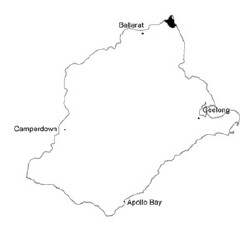 |
|
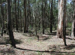 Open forests with deep soils on undulating slopes | 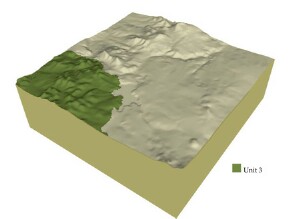 |
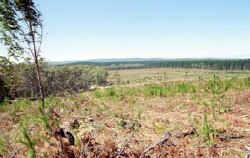
 | 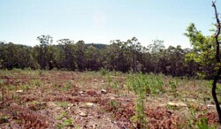 Cleared pine forestry plantation with new seedlings |
Component | 1 | 2 | 3 | 4 |
Proportion of soil-landform unit | 20% | 15% | 60% | 5% |
| CLIMATE Rainfall (mm) | Annual:1000 | |||
| Temperature (oC) | Minimum 6, Maximum 16 | |||
| Precipitation less than potential evapotranspiration | October-March | |||
| GEOLOGY Age and lithology | Ordovician marine sediments with minor Recent clay, sand and gravel and basalt | |||
| Geomorphology | ||||
| LANDUSE | Uncleared: Nature conservation; water supply; sport and recreation; residential development; softwood plantations Cleared: Softwood plantations; water supply; residiential development; sheet and beef cattle grazing | |||
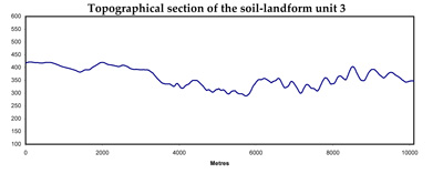
| TOPOGRAPHY Landscape | Rolling hills | |||
| Elevation range (m) | 560-740 | |||
| Local relief (m) | 30 | |||
| Drainage pattern | Dendritic | |||
| Drainage density (km/km2) | 2.2 | |||
| Landform | Hills | |||
| Landform element | Crest and steep slope | Sloep with deep soil | Slope with shallow soil | Drainage line |
| Slope and range (%) | 12 (5-20) | 10 (5-20) | 20 (5-30) | 2 (1-4) |
| Slope shape | Convex | Straight | Straight | Concave |
| NATIVE VEGETATION Ecological Vegetation Class | Herb-rich Foothll Forest/Shrubby Foothill Forest Complex (49.6%); Shrubby Foothill Forest (4.1%); Sedgy Riparian Woodland (3.4%); Herb-rich Foothill Forest (2.0%) | |||
| Dominant species | E. obliqua, E. dives, E. radiata, E. rubida | E. obliqua, E. viminalis, E. radiata, E. rubida, E. cypellocarpa | E. obliqua, E. viminalis, E. radiata, E. rubida, E. dives | E. obliqua, E. viminalis, E. radiata, E. rubida |
| SOIL Parent material | In situ weathered sandstone and shale | In situ weathered sandstone and shale | In situ weathered sandstone and shale | Alluvium, colluvium clay, silt, sand and gravel |
| Description (Corangamite Soil Group) | Shalow stony brown gradational soils (25) | Red texture contrast and red gradational soils, fine structure (26) | Brown, grey or yellow texture contrast and brown, grey or yellow gradational soils (25) | Brown gradational (earth) soil (34) |
| Soil type sites | ||||
| Surface texture | Gravelly loam | Fine sandy loam to clay loam | Fine sandy loam to clay loam | Clay loam |
| Permeability | High | High | Moderate to high | Moderate |
| Depth (m) | 0.5 | 2 | 1 | 2 |
| LAND CHARACTERISTICS, POTENTIAL AND LIMITATIONS | Steep slopes and low permeability leads to overland flow. This flow often creates sheet and rill erosion with major rainfall events. Leaching of salts also occur. | Steep slopes and low permeability leads to overland flow. This flow often creates sheet and rill erosion with major rainfall events. Leaching of salts also occur with nutrient decline. | Steep slopes and low permeability leads to overland flow. This flow often creates sheet and rill erosion with major rainfall events. Leaching of salts also occur with nutrient decline. | Moderate permeability and overland flow are common. Subsurface waterlogging is seasonal.. Gully erosion and leaching of salts also occur. Surface compaction can benefit from controlled traffic. |
© State of Victoria (Agriculture Victoria) 1996 - .

This work, Victorian Resources Online, is licensed under a Creative Commons Attribution 4.0 licence. You are free to re-use the work under that licence, on the condition that you credit the State of Victoria (Agriculture Victoria) as author, indicate if changes were made and comply with the other licence terms.
The licence does not apply to ‘branding’ or some ‘images or photographs’ that may be owned by third parties. We ask you to seek prior approval to use images using the VRO feedback form. Access to higher quality images can also be provided on request.
This page was last updated on .