
Soil/Landform Unit - Dimboola
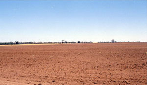
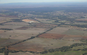 Looking south towards Dimboola from Arkona over the gentle rise that fringes the eastern half of the town |
0.71% of CMA region The Dimboola rises occur on the eastern margin of the Lowan Salt Valley soil-landform unit as part of the Calcareous North Western Dunefields and Plains with linear dunes sub-dominant (5.1.3). Source geologies include Neogene marine sand and silt (Parilla Sand); Quaternary aeolian dune sand (Lowan Sand). Landscape components include rises (crests and slopes) with calcareous gradational soils (Calcarosols) and sodic red texture contrast soils (Sodosols), drainage lines and playa plains with cracking clays (Vertosols), and gentle plains with calcareous gradational soils and sodic yellow and grey texture contrast soils (Sodosols). Dryland cereal cropping is the major land use with hardsetting (weakly structured) surfaces susceptible to sheet and rill erosion along with wind erosion. Remnant vegetation communities include woodlands, mallee and shrubland. Some of the more prevalent vegetation communities include Low Rises Woodland, Lowan Sand Mallee, Sandstone Ridge Shrubland, Ridged Plains Mallee, Ridged Plains Mallee, Plains Woodland, Lignum Swampy Woodland and Plains Savannah. | 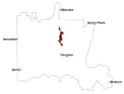 |
 Rise east of Jeparit on the edge of the Lowan salt valley | 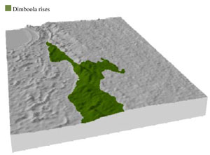 |
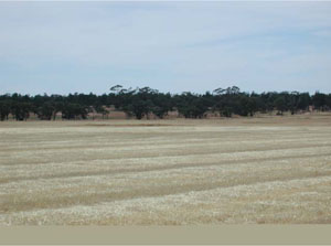
|  Cultimated soils near Tarranyurk |
Component | 1 | 2 | 3 | 4 | 5 |
Proportion of soil-landform unit | 10% | 30% | 10% | 15% | 35% |
| CLIMATE Rainfall (mm) | Annual: 395 | ||||
| Temperature (oC) | Minimum 8, Maximum 22 | ||||
| Precipitation less than potential evapotranspiration | September–April | ||||
| GEOLOGY Age and lithology | Neogene marine sand and silt (Parilla Sand); Quaternary aeolian dune sand (Lowan Sand); Quaternary paludal silt and clay | ||||
| Geomorphology | |||||
| LANDUSE | Uncleared areas: nature conservation Cleared areas: dryland cropping; sheep grazing | ||||
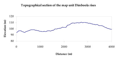
| TOPOGRAPHY Landscape | Gently undulating rises | ||||
| Elevation range (m) | 77–144 | ||||
| Local relief (m) | 15 | ||||
| Drainage pattern | Dendritic | ||||
| Drainage density (km/km2) | 0.7 | ||||
| Landform | Rises | ||||
| Landform element | Rise crest | Rise slope | Drainage line | Playa | Plain |
| Slope and range (%) | 4 (1-7) | 14 (5-37) | 5 (2-9) | 11 (3-15) | 4 (2-9) |
| Slope shape | Straight | Straight | Convex | Straight | Concave |
| NATIVE VEGETATION Ecological Vegetation Class | Low Rises Woodland (28.3%), Ridged Plains Mallee (19.3%), Riverine Chenopod Woodland (11.7%), Plains Woodland (10.4%), Other (28.1%) | ||||
| SOIL Parent material | Sand and silt | Marine and aeolian sand and silt | Alluvial gravel, sand and silt | Swamp silt and clay | Aeolian sand and silt |
| Description (Corangamite Soil Group) | Sodic red texture contrast soils (27) | Cracking clay soils (29) | Cracking clay soils (29) | ||
| Soil type sites | |||||
| Surface texture | Sandy loam | Sandy clay loam | Fine sandy clay loam | Fine sandy clay loam | Sandy clay loam to clay loam |
| Permeability | Moderate | Moderate | Slow | Slow | Moderate |
| Depth (m) | > 1.5 | > 2 | > 2 | > 2 | > 2 |
| LAND CHARACTERISTICS, POTENTIAL AND LIMITATIONS Critical land features, processes, forms | |||||
| Hardsetting (weakly structured) surface susceptible to sheet and rill erosion along with wind erosion. Dispersive and deep subsoils susceptible to gully erosion where exposed. Soils are prone to compaction at critical moisture contents. | Moderately well drained soil with dispersive subsoil subject to erosion where exposed. Surface soil may be susceptible to sheet and wind erosion where weakly structured (hardsetting). | Drainage lines can be subject to periodic inundation especially in low lying areas. Surfaces are slightly vulnerable to sheet erosion and wind erosion. Soils may be susceptible to compaction. | Plains are subject to periodic inundation and waterlogging. Surfaces are slightly vulnerable to sheet erosion and wind erosion. Soils may be susceptible to compaction. | Moderately well drained soil with dispersive subsoil subject to erosion where exposed. Surface soil may be susceptible to sheet and wind erosion where weakly structured (hardsetting). Soils compact at critical moisture contents. | |
© State of Victoria (Agriculture Victoria) 1996 - .

This work, Victorian Resources Online, is licensed under a Creative Commons Attribution 4.0 licence. You are free to re-use the work under that licence, on the condition that you credit the State of Victoria (Agriculture Victoria) as author, indicate if changes were made and comply with the other licence terms.
The licence does not apply to ‘branding’ or some ‘images or photographs’ that may be owned by third parties. We ask you to seek prior approval to use images using the VRO feedback form. Access to higher quality images can also be provided on request.
This page was last updated on .