
Soil/Landform Unit - Perenna undulating sand plains and rises
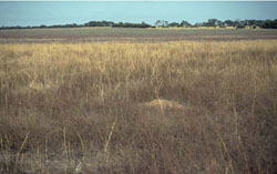 Dune crest within a gently undulating sand plain near the Wyperfield National Park |
1.12% of CMA region Consisting of a few large and greater smaller occurrences north of Kaniva through to Perenna, this low sand plain and dunefield complex has Cainozoic sediments as NNW/SSW orientated ridges and depressions. There are three components dominated by rise slope s. Sand plain and rise crests also occur across the unit. Site drainage is moderately well drained, but slow on lower areas. Sodic yellow, brown and grey texture contrast soils (Sodosols) with some grey cracking clay soils (Vertosols) are major soils with minor sodic red contrast soils occurring on the rise crests. Sheet and rill erosion are major land degradation susceptibility issues on the texture contrast soils, given slope and surface condition. The plains and rises have a high susceptibility to wind erosion. Broadacre cereal cropping is the major enterprise with some grazing (sheep, some cattle). Woodland and mallee vegetation communities such as Low Rises Woodland, Heathy Mallee, Red Swale Mallee, Ridged Plains Mallee, Plains Woodland, Parilla Mallee and Shallow Sands Woodland dominate remnant vegetation. | 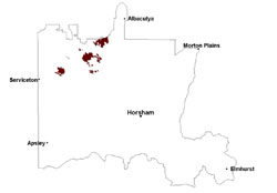 |
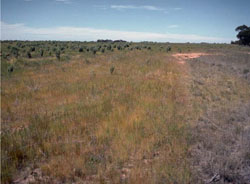 Lower sandy rise slope of a gently undualting plain | 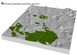 |
 | 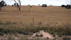 Gently undulating sand plain near Propodollah |
Component | 1 | 2 | 3 |
Proportion of soil-landform unit | 15% | 60% | 25% |
| CLIMATE Rainfall (mm) | Annual: 405 | ||
| Temperature (oC) | Minimum 8, Maximum 22 | ||
| Precipitation less than potential evapotranspiration | September–April | ||
| GEOLOGY Age and lithology | Quaternary paludal silt and clay; Neogene marine sand and silt (Parilla Sand); Quaternary aeolian dune sand (Lowan Sand) | ||
| Geomorphology | |||
| LANDUSE | Uncleared areas: nature conservation Cleared areas: dryland cropping; sheep grazing | ||
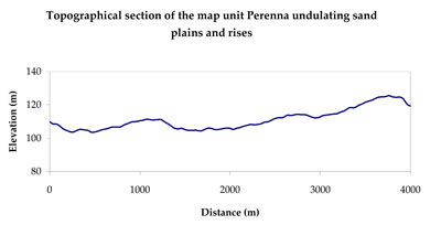
| TOPOGRAPHY Landscape | Undulating sand plains and rises | ||
| Elevation range (m) | 91–185 | ||
| Local relief (m) | 10 | ||
| Drainage pattern | Dendritic | ||
| Drainage density (km/km2) | 0.1 | ||
| Landform | Sand plains | ||
| Landform element | Rise crest | Rise slope | Sand plain |
| Slope and range (%) | 5 (1-10) | 5 (3-10) | 3 (1-8) |
| Slope shape | Convex | Convex | Concave |
| NATIVE VEGETATION Ecological Vegetation Class | Low Rises Woodland (31.4%), Parilla Mallee (20.1%), Sandstone Ridge Shrubland (13.2%), Plains Woodland (12.4%), Other (22.0%) | ||
| SOIL Parent material | Aeolian sand | Aeolian sand | Marine sand and silt, paludal silt and clay |
| Description (Corangamite Soil Group) | Sodic red texture contrast soils (35) | Sodic brown, yellow and grey texture contrast soils (36) | |
| Soil type sites | |||
| Surface texture | Sandy clay loam | Sandy clay loam | Sandy loam - medium clay |
| Permeability | Moderate | Moderate | Slow - moderate |
| Depth (m) | 1.6 | > 2 | > 2 |
| LAND CHARACTERISTICS, POTENTIAL AND LIMITATIONS Critical land features, processes, forms | Hardsetting soil surface susceptible to sheet and rill erosion, and wind erosion where exposed. Dispersive and deep subsoils susceptible to gully erosion on steeper slopes. Compaction of soil dependent upon depth of force and moisture content. Topsoil may be susceptible to acidification. | Susceptible to wind and sheet erosion where exposed. Low inherent soil fertility in well drained surface soil abruptly over structured subsoil. Susceptible to compaction where hardsetting with restricted drainage. Upper soil susceptible to acidification. | Susceptible to inundation and waterlogging in closed depressions. Slightly susceptible to surface wind and sheet erosion where exposed. Gully erosion can occur where subsoils are dispersive and deep. Soils susceptible to compaction at critical moisture contents. |
© State of Victoria (Agriculture Victoria) 1996 - .

This work, Victorian Resources Online, is licensed under a Creative Commons Attribution 4.0 licence. You are free to re-use the work under that licence, on the condition that you credit the State of Victoria (Agriculture Victoria) as author, indicate if changes were made and comply with the other licence terms.
The licence does not apply to ‘branding’ or some ‘images or photographs’ that may be owned by third parties. We ask you to seek prior approval to use images using the VRO feedback form. Access to higher quality images can also be provided on request.
This page was last updated on .