
Soil/Landform Unit - Lowan salt valley
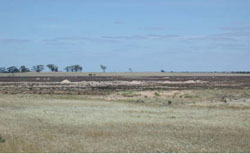
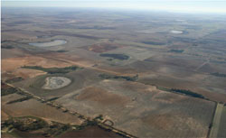 Looking north-west from near Arkona along the Lowan salt valley gypseous lakes |
1.49% of CMA region Running from west of Dimboola to the north-western tip of Lake Hindmarsh is what has historically been referred to as the ‘Lowan salt valley’. Believed to have once been a southern path for the Murray River, the valley is a northern extension of the Douglas Depression to the south, being separated by deposits of aeolian sands as part of the Little Desert. The valley, like the Douglas Depression, is relatively gentle in nature with the eastern margin much more pronounced than the subtle graduation into the valley on the west. Landforms including rises and plains are common with soils including calcareous gradational soils (Calcarosols) and sodic red texture contrast soils (Sodosols) prominent on rises while sodic yellow and grey texture contrast soils (Sodosols) and seasonally wet soils (Hydrosols) common on plains and swamps. Salts within the valley are often found as significant deposits of gypsum in lower topographic positions and are often excavated for agricultural applications. Soils may be prone to wind erosion where ground coverage is poor and areas are prone to seasonal inundation. There are a variety of woodland, heathland and mallee vegetation types present including Shallow Sands Woodland, Lignum Swampy Woodland, Woorinen Mallee, Parilla Mallee, Low Rises Woodland, Sandstone Ridge Shrubland and Ridged Plains Mallee. | 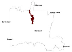 |
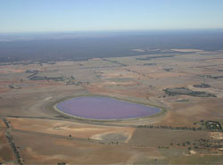 Pink Lake, looking south towards the Little Desert | 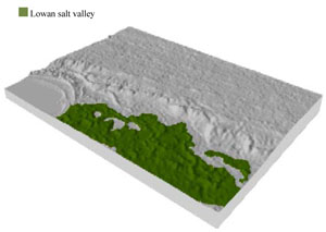 |
 |  |
Component | 1 | 2 | 3 | 4 | 5 | 6 |
Proportion of soil-landform unit | 5% | 30% | 10% | 15% | 10% | 30% |
| CLIMATE Rainfall (mm) | Annual: 385 | |||||
| Temperature (oC) | Minimum 9, Maximum 22 | |||||
| Precipitation less than potential evapotranspiration | September–April | |||||
| GEOLOGY Age and lithology | Quaternary paludal silt and clay; Quaternary aeolianites and evaporites (Yamba Formation); Quaternary aeolian dune sand (Lowan Sand) | |||||
| Geomorphology | ||||||
| LANDUSE | Uncleared areas: nature conservation Cleared areas: dryland cropping; sheep grazing; gypsum extraction | |||||
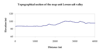
| TOPOGRAPHY Landscape | Valley plain | |||||
| Elevation range (m) | 79–127 | |||||
| Local relief (m) | 10 | |||||
| Drainage pattern | Dendritic | |||||
| Drainage density (km/km2) | 0.5 | |||||
| Landform | Rises | Plains | ||||
| Landform element | Low rise crest | Low rise slope | Lunette | Playa | Drainage line | Plain |
| Slope and range (%) | 4 (1-7) | 4 (1-7) | 5 (2-9) | 1 (0-2) | 1 (0-2) | 2 (1-6) |
| Slope shape | Straight | Straight | Convex | Straight | Concave | Convex |
| NATIVE VEGETATION Ecological Vegetation Class | Plains Woodland (24.0%), Low Rises Woodland (21.7%), Ridged Plains Mallee (20.1%), Plains Savannah (11.1%), Other (21.8%) | |||||
| SOIL Parent material | Marine sand and silt, aeolian sand | Marine sand and silt | Aeolian sand | Paludal silt and clay, evaporites and aeolianites | Fluvial gravel, sand and silt | Marine sand and silt |
| Description (Corangamite Soil Group) | Calcareous gradational soils (26) | Seasonally wet soils: sodic yellow and grey texture contrast soils (33) | ||||
| Soil type sites | ||||||
| Surface texture | Sandy loam to clay loam | Sandy loam to clay loam | Clay loam | Sand | Sand to loamy sand | Loamy sand to sandy clay loam |
| Permeability | Moderate to high | Moderate | Moderate | Slow | Slow | Slow |
| Depth (m) | > 2 | > 2 | > 2 | > 1.5 | > 2 | > 2 |
| LAND CHARACTERISTICS, POTENTIAL AND LIMITATIONS Critical land features, processes, forms | Moderately well drained soil with dispersive subsoil subject to erosion where exposed. Surfaces can be hardsetting and susceptible to sheet and rill erosion. Surface soil may be susceptible to sheet and wind erosion where apedal. Soils are prone to compaction at critical moisture contents. | Moderately well drained soil with dispersive subsoil subject to erosion where exposed. Surfaces can be hardsetting and susceptible to sheet and rill erosion. Surface soil may be susceptible to sheet and wind erosion where apedal. Soils are prone to compaction at critical moisture contents. | Moderately well drained soil with dispersive subsoil subject to erosion where exposed. Surface soil may be susceptible to sheet and wind erosion where apedal. | Susceptible to seasonal inundation, waterlogging and ultimately soil salinity. Upper soils susceptible to sheet erosion and wind erosion when exposed. | Susceptible to seasonal inundation and waterlogging. Upper soils susceptible to sheet erosion and wind erosion when exposed. | Wind erosion along with sheet and rill erosion occur on hardsetting surfaces with little organic matter. Subsoils are dispersive and susceptible to gully erosion on steeper slopes. Soils compact at critical moisture contents. |
© State of Victoria (Agriculture Victoria) 1996 - 2025.

This work, Victorian Resources Online, is licensed under a Creative Commons Attribution 4.0 licence. You are free to re-use the work under that licence, on the condition that you credit the State of Victoria (Agriculture Victoria) as author, indicate if changes were made and comply with the other licence terms.
The licence does not apply to ‘branding’ or some ‘images or photographs’ that may be owned by third parties. We ask you to seek prior approval to use images using the VRO feedback form. Access to higher quality images can also be provided on request.
This page was last updated on 25/01/2019.