
Soil/Landform Unit - Werrap lakes and lunettes
Landform Unit Description
Page top
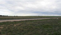
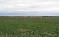 Looking north-west over a level plain north of Pella |
0.26% of CMA region This unit of low relative relief terrain of plains and swamps occurs north of Lake Hindmarsh. This low depositional plain is part of the North West Dunfields and Plains Calcareous dunefield geomorphological unit. These broad plains and low dunefields of Quaternary riverine and aeolian sediments occur between Lakes Hindmarsh and Albacutya flanking the Wimmera River and form depressions within a broader ridge, dune and plain complex (Hopetoun). These depressions may be gypseous. Level plains, lunettes, swamps/playas and drainage depressions all occur. Soil types include yellow and grey sodic texture contrast soils (Sodosols). Grey and brown cracking clay soils (Vertosols) also occur in the drainage depressions and calcareous gradational soils (Calcarosols) occur on the lunettes. Wind erosion on the windward side of rises and lunettes may be a land degration issue. Land use includes dryland cropping, gypsum quarrying and grazing (sheep). Woodland and mallee vegetation present include Parilla Mallee, Woorinen Mallee, Lignum Swampy Woodland, Plains Woodland, Riverine Chenopod Woodland, Ridged Plains Mallee, Heathy Mallee and Lowan Sands Mallee. | 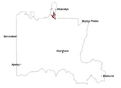 |
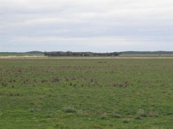 Gypsum deposits located within a plain (former swamp) | 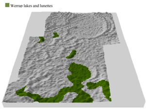 |
 |  Plain and lunette |
Component | 1 | 2 | 3 | 4 |
Proportion of soil-landform unit | 20% | 40% | 25% | 15% |
| CLIMATE Rainfall (mm) | Annual: 375 | |||
| Temperature (oC) | Minimum 9, Maximum 22 | |||
| Precipitation less than potential evapotranspiration | September–April | |||
| GEOLOGY Age and lithology | Neogene marine sand and silt (Parilla Sand); Quaternary paludal silt and clay; Quaternary aeolian lunettes, sand, silt and clay | |||
| Geomorphology | ||||
| LANDUSE | Uncleared areas: nature conservation Cleared areas: dryland cropping; gypsum extraction | |||
| TOPOGRAPHY Landscape | Lake lunette complex | |||
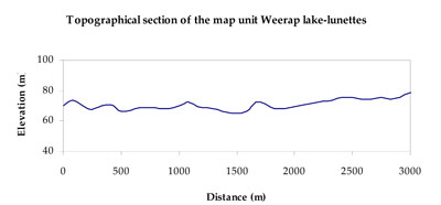
| Elevation range (m) | 76–109 | |||
| Local relief (m) | 5 | |||
| Drainage pattern | Dendritic–derranged | |||
| Drainage density (km/km2) | 0.2 | |||
| Landform | Former lake beds | Plains | ||
| Landform element | Playa/swamp | Level plain | Lunette | Drainage depression |
| Slope and range (%) | 0 (0-1) | 0 (0-1) | 3 (1-10) | 0 (0-1) |
| Slope shape | Straight | Linear | Convex | Concave |
| NATIVE VEGETATION Ecological Vegetation Class | Ridged Plains Mallee (25.7%), Riverine Chenopod Woodland (19.3%), Woorinen Mallee (18.2%), Plains Woodland (8.9%), Other (26.3%) | |||
| SOIL Parent material | Paludal silt and clay | Marine sand and silt | Aeolian sand, silt and clay | Marine sand and silt |
| Description (Corangamite Soil Group) | Sodic yellow and grey texture contrast soils (28) | Cracking clay soils (29) | ||
| Soil type sites | ||||
| Surface texture | Clay loam | Loamy sand | Sandy loam to clay loam | Fine sandy clay loam |
| Permeability | Slow to very slow | Moderate to slow | Moderate | Very slow |
| Depth (m) | > 2 | > 2 | > 2 | > 2 |
| LAND CHARACTERISTICS, POTENTIAL AND LIMITATIONS Critical land features, processes, forms | Susceptible to seasonal inundation, waterlogging and ultimately soil salinity. Upper soils susceptible to sheet erosion and wind erosion when exposed. | Wind erosion along with sheet and rill erosion occur on hardsetting surfaces with little organic matter. Subsoils are dispersive and susceptible to gully erosion on steeper slopes. Soils compact at critical moisture contents. | Moderately well drained soil with dispersive subsoil subject to erosion where exposed. Surface soil may be susceptible to sheet and wind erosion where apedal. | Soils can be subject to inundation and waterlogging especially in low lying areas. Surfaces are slightly vulnerable to sheet erosion and wind erosion. Soils may be susceptible to compaction. |
© State of Victoria (Agriculture Victoria) 1996 - .

This work, Victorian Resources Online, is licensed under a Creative Commons Attribution 4.0 licence. You are free to re-use the work under that licence, on the condition that you credit the State of Victoria (Agriculture Victoria) as author, indicate if changes were made and comply with the other licence terms.
The licence does not apply to ‘branding’ or some ‘images or photographs’ that may be owned by third parties. We ask you to seek prior approval to use images using the VRO feedback form. Access to higher quality images can also be provided on request.
This page was last updated on .