
Soil/Landform Unit - Quantong dunes and swales
Landform Unit Description
Page top
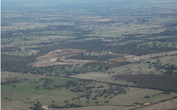 Sand plains and dunes surrounding Mount Talbot |
1.08% of CMA region Sand dunes and swales south and north of Quantong form part of the undulating siliceous dunefields of the North West Dunfields and Plains. These broad and isolated dunefields with linear dunes occur south-west of Horsham, flanking the Wimmera River units (Drung, St Helens) as well as an area south to the western Black Range on a older plain (Glencoe). Dunefield slopes and swales are the prominent landform components of this unit. Drainage is indistinguishable and restricted to localised swales. Soils are mainly yellow and brown sodic texture contrast soils (Sodosols) with deep sandy topsoils or deep sandy soils (Tenosols) generally without pans, occasionally pans are found. Sodic, yellow and brown texture contrast soils also occur in the swales. Sheet and rill erosion with wind erosion on the windward side are land degradation threats. Land cover is important for land stability especially where surfaces have little organic matter. These units are used for grazing or remain under native vegetation given their low fertility. Vegetation is dominated by a number of woodland communities (including Shallow Sands Woodland, Plains Woodland, Lateritic Woodland), heathlands (including Sand Heathland), wetlands and meadows. | 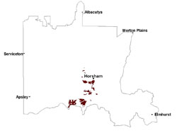 |
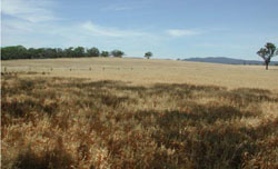
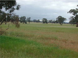 Mixed annual perennial pasture west of Mount Talbot | 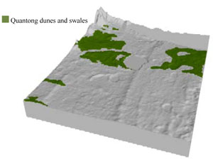 |
 |  Sandplains and dunes west of Mount Talbot |
Component | 1 | 2 |
Proportion of soil-landform unit | 90% | 10% |
| CLIMATE Rainfall (mm) | Annual: 520 | |
| Temperature (oC) | Minimum 8, Maximum 21 | |
| Precipitation less than potential evapotranspiration | October–April | |
| GEOLOGY Age and lithology | Quaternary marine and non-marine aeolian dune sand; Neogene sand and silt (Parilla Sand) | |
| Geomorphology | 5.2.2 Linear dunes of the Siliceous North West Dunefields and Plains | |
| LANDUSE | Uncleared areas: nature conservation Cleared areas: dryland cropping; sheep and beef cattle grazing; dairy farming; irrigated horticulture | |
| TOPOGRAPHY Landscape | Dunes and swales | |
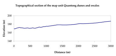
| Elevation range (m) | 105–252 | |
| Local relief (m) | 10 | |
| Drainage pattern | Dendritic | |
| Drainage density (km/km2) | 0.6 | |
| Landform | Dunefields | |
| Landform element | Dune slope | Swale |
| Slope and range (%) | 4 (1-10) | 2 (0-4) |
| Slope shape | Straight | Convex |
| NATIVE VEGETATION Ecological Vegetation Class | Shallow Sands Woodland (30.3%), Plains Woodland (19.5%), Heathy Woodland (10.1%), Plains Sedgy Woodland (8.6%), Other (30.9%) | |
| SOIL Parent material | Aeolian sand | Alluvial and paludal sand, silt and clay |
| Description (Corangamite Soil Group) | Sodic yellow and grey texture contrast soils (32) | |
| Soil type sites | LSWW8, LSWW7, WLRA74 | |
| Surface texture | Sand to loamy sand | Loamy sand |
| Permeability | High | Slow |
| Depth (m) | > 1.5 | > 1.5 |
| LAND CHARACTERISTICS, POTENTIAL AND LIMITATIONS Critical land features, processes, forms | Soils with low organic matter levels can be susceptible to wind and sheet erosion where exposed. Low inherent soil fertility. | Susceptible to wind and sheet erosion where exposed. Low inherent fertility but well drained to pans or subsoil. Susceptible to compaction where hardsetting and poor drainage occurs. |
© State of Victoria (Agriculture Victoria) 1996 - .

This work, Victorian Resources Online, is licensed under a Creative Commons Attribution 4.0 licence. You are free to re-use the work under that licence, on the condition that you credit the State of Victoria (Agriculture Victoria) as author, indicate if changes were made and comply with the other licence terms.
The licence does not apply to ‘branding’ or some ‘images or photographs’ that may be owned by third parties. We ask you to seek prior approval to use images using the VRO feedback form. Access to higher quality images can also be provided on request.
This page was last updated on .