
Soil/Landform Unit - Nhill lakes and lunettes
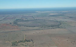 Looking south over a lake (south of Nhill) towards the Little Desert |
0.39% of CMA region This unit consists of many small occurrences from Nhill to the Big Desert to the north. This depression (lake and lunette complex) unit is part of the ridges with sands and flats of the North West Dunefields and Plains. These swamps, plains and lunettes of Quaternary sediments occur between the NNW/SSE orientated former stranded beach ridges located between the Little and Big Deserts (5.2). Swamps, playa plain, lunettes and low gentle rises are all within this unit. Site drainage is slow to very slow. Soils are predominantly grey and brown cracking clay soils (Vertosols) on the plains and swamps with sodic red texture contrast soils (Sodosols) on the rises. Swamps are prone to seasonal waterlogging and inundation, soil compaction is also a susceptibility factor with these soils (heavier soils). Broadacre cereal cropping is prominent with some grazing (sheep, some cattle). A number of vegetation communities have been recorded including; Shallow Sands Woodland, Parilla Mallee, Plains Savannah, Woorinen Mallee, Lignum Swampy Woodland, Plains Woodland, Ridged Plains Mallee, Sandstone Ridge Shrubland and Low Rises Woodland. | 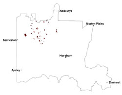 |
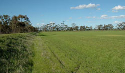
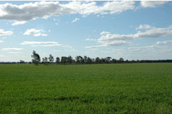 Cereal crops and remnant vegetation on levee of lake | 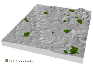 |
 |  Augmented lake levee along lake between crops and remnant vegetation |
Component | 1 | 2 | 3 | 4 |
Proportion of soil-landform unit | 15% | 25% | 20% | 40% |
| CLIMATE Rainfall (mm) | Annual: 420 | |||
| Temperature (oC) | Minimum 8, Maximum 22 | |||
| Precipitation less than potential evapotranspiration | September–April | |||
| GEOLOGY Age and lithology | Quaternary paludal silt and clay; Quaternary aeolian dune sand (Lowan Sand); Neogene marine sand and silt (Parilla Sand) | |||
| Geomorphology | ||||
| LANDUSE | Uncleared areas: water supply; nature conservation Cleared areas: dryland cropping; sheep grazing; water supply | |||
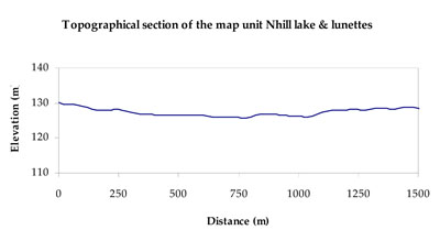
| TOPOGRAPHY Landscape | Lake and lunette complex | |||
| Elevation range (m) | 80–159 | |||
| Local relief (m) | 1–2 | |||
| Drainage pattern | Dendritic | |||
| Drainage density (km/km2) | 1.2 | |||
| Landform | Rises | Plains | ||
| Landform element | Low gentle rise | Playa plain | Lunette | Swamp bed |
| Slope and range (%) | 3 (1-8) | 0 (0-1) | 3 (1-10) | 0 (0-1) |
| Slope shape | Convex | Linear | Convex | Concave |
| NATIVE VEGETATION Ecological Vegetation Class | Low Rises Woodland (21.1%), Lignum Swampy Woodland (15.5%), Ridged Plains Mallee (12.9%), Plains Savannah (12.7%), Other (37.8%) | |||
| SOIL Parent material | Marine sand and silt, aeolian sand | Paludal silt and clay | Aeolian sand | Paludal silt and clay |
| Description (Corangamite Soil Group) | Sodic brown, yellow and grey texture contrast soils (36) | Grey and brown cracking clay soils (37) | Sodic red texture contrast soils (35) | Seasonally wet soils: sodic yellow and grey texture contrast soils (33) |
| Soil type sites | LS3, LSWW9, LSWW5 | |||
| Surface texture | Sandy clay loam | Medium clay | Sandy clay loam | Sand |
| Permeability | Slow to moderate | Slow to very slow | Moderate | Very slow |
| Depth (m) | > 2 | > 2 | > 2 | > 2 |
| LAND CHARACTERISTICS, POTENTIAL AND LIMITATIONS Critical land features, processes, forms | Susceptible to wind and sheet erosion where exposed. Well drained surface soil abrupt boundary to structured subsoil. Susceptible to compaction where hardsetting with restricted drainage. Upper soil susceptible to acidification. | Susceptible to seasonal inundation and waterlogging. Surface soils friable and only slightly susceptible to wind erosion. Soils susceptible to compaction at critical moisture contents. | Hardsetting soil surface susceptible to sheet and rill erosion, and wind erosion where exposed. Dispersive and deep subsoils susceptible to gully erosion on steeper lunette slopes. Compaction of soil dependent upon depth of force and moisture content. | Susceptible to seasonal inundation, waterlogging and ultimately soil salinity. |
© State of Victoria (Agriculture Victoria) 1996 - .

This work, Victorian Resources Online, is licensed under a Creative Commons Attribution 4.0 licence. You are free to re-use the work under that licence, on the condition that you credit the State of Victoria (Agriculture Victoria) as author, indicate if changes were made and comply with the other licence terms.
The licence does not apply to ‘branding’ or some ‘images or photographs’ that may be owned by third parties. We ask you to seek prior approval to use images using the VRO feedback form. Access to higher quality images can also be provided on request.
This page was last updated on .