
Soil/Landform Unit - Vectis undulating rises and low hills
Landform Unit Description
Page top
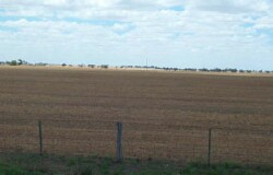 Low rises with subdued plains near Vectis East |
0.57% of CMA region This terrain including rises, low hills, (dunes) plains and occurs west-north-west of Horsham. This low rise/low hill and plain complex is part of the North West Dunefields and Plains calcareous dunefields. This complex of Quaternary aeolian and lacustrine sediments encompasses depressions and sand plains and is bound to the east by the self-mulching clay Kalkee plains. Rise and low hill upper and lower slopes are dominant landform elements. Drainage is aligned to the terrain, draining west to the Wimmera River. Soils include brown and yellow grey sodic texture contrast soils (Sodosols) with grey and brown cracking clay soils (Vertosols) on plains and in local depressions. Red sodic texture contrast soils (Sodosols) occur on the crests and gentle rise slopes. Sheet and rill erosion along with wind erosion can be a threat where topsoils are light textured and exposed. This unit is used for grazing (sheep, beef cattle) and dryland cropping. Vegetation consists of a range of woodland, shrubland and mallee vegetation including communities such as Low Rises Woodland, Ridged Plains Mallee, Plains Woodland, Lignum Swampy Woodland and Riverine Chenopod Woodland. Plains Savannah has also been recorded. |  |
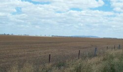
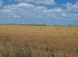 Dryland cropping is a major landuse of the plains | 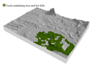 |
 |  Looking south towards Mount Arapiles |
Component | 1 | 2 | 3 | 4 | 5 | 6 |
Proportion of soil-landform unit | 8% | 15% | 30% | 20% | 25% | 2% |
| CLIMATE Rainfall (mm) | Annual: 450 | |||||
| Temperature (oC) | Minimum 8, Maximum 21 | |||||
| Precipitation less than potential evapotranspiration | September–April | |||||
| GEOLOGY Age and lithology | Quaternary paludal silt and clay; Quaternary fluvial gravel, sand and silt, Quaternary aeolian dune sand (Lowan Sand); Quaternary aeolianites and evaporates (Yamba Formation ) | |||||
| Geomorphology | ||||||
| LANDUSE | Uncleared areas: water supply; nature conservation Cleared areas: sheep and beef cattle grazing; dryland cropping | |||||
| TOPOGRAPHY Landscape | Undulating rises and low hills | |||||
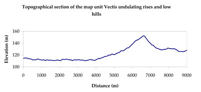
| Elevation range (m) | 103–158 | |||||
| Local relief (m) | 20–40 | |||||
| Drainage pattern | Dendritic | |||||
| Drainage density (km/km2) | 0.5 | |||||
| Landform | Moderately undulating rises and low hills | Gently undulating rises | Drainage depressions | |||
| Landform element | Gentle crest | Upper slope | Lower slope | Gentle rise slope | Flat | Drainage line |
| Slope and range (%) | 2 (0-5) | 8 (3-15) | 4 (2-10) | 3 (1-10) | 0 (0-1) | 2 (0-12) |
| Slope shape | Convex | Convex | Straight | Convex | Straight | Concave |
| NATIVE VEGETATION Ecological Vegetation Class | Low Rises Woodland (40.0$), Ridged Plains Mallee (17.7%), Plains Woodland (16.2%), Riverine Chenopod Woodland (8.9%), Other (15.7%) | |||||
| SOIL Parent material | Aeolian sand, marine sand and silt | Aeolian sand, marine sand and silt | Fluvial gravel, sand and silt | Marine sand and silt | Paludal silt and clay | Alluvial gravel, sand and silt |
| Description (Corangamite Soil Group) | Sodic red texture contrast soils (27) | Sodic red texture contrast soils (27) | Sodic yellow and grey texture contrast soils (28) | Cracking clay soils (34) | Cracking clay soils (34) | |
| Soil type sites | ||||||
| Surface texture | Sandy loam | Sandy loam | Loamy sand | Sandy loam to light clay | Medium clay | Medium clay |
| Permeability | Moderate | Moderate | Slow to moderate | Moderate to slow | Slow | Very slow |
| Depth (m) | > 1.5 | > 1.5 | > 2 | > 3 | > 3 | > 3 |
| LAND CHARACTERISTICS, POTENTIAL AND LIMITATIONS Critical land features, processes, forms | Hardsetting surface susceptible to sheet and rill erosion along with wind erosion. Dispersive and deep subsoils susceptible to gully erosion on steeper slopes. Soils are prone to compaction at critical moisture contents. | Hardsetting surface susceptible to sheet and rill erosion along with wind erosion. Dispersive and deep subsoils susceptible to gully erosion on steeper slopes. Soils are prone to compaction at critical moisture contents. | Wind erosion along with sheet and rill erosion occur on hardsetting surfaces with little organic matter. Subsoils are dispersive and susceptible to gully erosion on steeper slopes. Soils compact at critical moisture contents. | Hardsetting surface susceptible to sheet and rill erosion along with wind erosion. Dispersive and deep subsoils susceptible to gully erosion on steeper slopes. Clayey surface soils are friable and only slightly susceptible to wind erosion due to self-mulching nature. Soils may be susceptible at critical moisture contents and have variable resilience to compaction. | High clay content results in restricted soil drainage, but can be variable due to micro relief (gilgai). Surface soils are friable and only slightly susceptible to wind erosion due to self-mulching nature. Soils may be susceptible at critical moisture contents and have variable resilience to compaction. | High clay content results in restricted soil drainage, but can be variable due to micro relief (gilgai). Surface soils are friable and only slightly susceptible to wind erosion due to self-mulching nature. Soils may be susceptible at critical moisture contents and have variable resilience to compaction. |
© State of Victoria (Agriculture Victoria) 1996 - .

This work, Victorian Resources Online, is licensed under a Creative Commons Attribution 4.0 licence. You are free to re-use the work under that licence, on the condition that you credit the State of Victoria (Agriculture Victoria) as author, indicate if changes were made and comply with the other licence terms.
The licence does not apply to ‘branding’ or some ‘images or photographs’ that may be owned by third parties. We ask you to seek prior approval to use images using the VRO feedback form. Access to higher quality images can also be provided on request.
This page was last updated on .