
Soil/Landform Unit - Kiata rises
 Gently undulating rises towards Kinimakatka along the Western Highway |
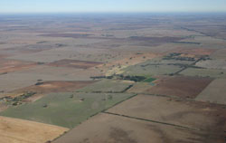
2.76% of CMA region Gently undulating rises north of the Little Desert form a significant portion of the ridges with sand and flats (5.5.1). The rises are part of the North West Dunefields and Plains with the landscape dominated by low gentle rises, plains and drainage depressions. The rises are composed of Parilla Sand with a veneer of Woorinen Formation and Lowan Formation (aeolian sand, silt and clay) that has led to the development of red sodic texture contrast soils (Sodosols) with brown, yellow and grey equivalents located lower in the topographic sequence. Cracking clays are found on plains and drainage depressions. While land use is dominated by cereal cropping and sheep grazing, hardsetting soil surfaces on these texture contrast soils makes them vulnerable to sheet and rill erosion, as well as wind erosion where exposed. Woodland and mallee vegetation communities such as Parilla Mallee, Plains Savannah, Plains Woodland, Ridged Plains Mallee, Lowan Sands Mallee and Low Rises Woodland dominate remnant vegetation. Sandstone Ridge Shrubland is also found along sandstone ridges and rises. | 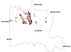 |
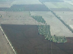 Rise trending north north-westerly with revegetation works | 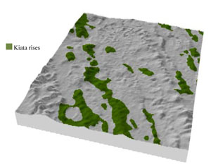 |
 | 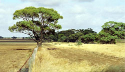 Undulating rises with roadside remnant vegetation |
Component | 1 | 2 | 3 | 4 |
Proportion of soil-landform unit | 10% | 55% | 30% | 5% |
| CLIMATE Rainfall (mm) | Annual: 425 | |||
| Temperature (oC) | Minimum 8, Maximum 22 | |||
| Precipitation less than potential evapotranspiration | September–April | |||
| GEOLOGY Age and lithology | Quaternary paludal silt and clay; Neogene marine sand and silt (Parilla Sand); Quaternary aeolian dune sand (Lowan Sand) | |||
| Geomorphology | ||||
| LANDUSE | Uncleared areas: nature conservation Cleared areas: dryland cropping; sheep grazing | |||
| TOPOGRAPHY Landscape | Gently undulating rises | |||
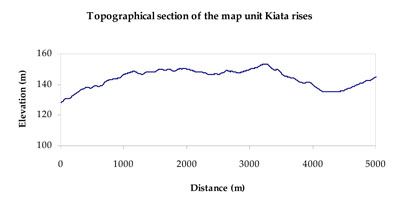
| Elevation range (m) | 84–183 | |||
| Local relief (m) | 10–15 | |||
| Drainage pattern | Dendritic | |||
| Drainage density (km/km2) | 0.2 | |||
| Landform | Low rises | Plains | Drainage depressions | |
| Landform element | Ridge crest (gentle crest) | Side slope | Lower slope (undulating plain) | Drainage line |
| Slope and range (%) | 3 (2-6) | 2 (1-5) | 3 (0-5) | 1 (0-3) |
| Slope shape | Convex | Linear | Straight | Concave |
| NATIVE VEGETATION Ecological Vegetation Class | Low Rises Woodland (32.9%), Ridged Plains mallee (17.2%), Plains Woodland (16.1%), Shallow Sands Woodland (14.9%), Other (20.0%) | |||
| SOIL Parent material | Marine sand and silt | Marine sand and silt | Marine sand and silt | Alluvial sand and silt, paludal silt and clay |
| Description (Corangamite Soil Group) | Sodic red texture contrast soils (35) | Sodic red texture contrast soils (35) | Grey and brown cracking clay soils (37) | |
| Soil type sites | LS3, LSWW9, LSWW5 | |||
| Surface texture | Sandy clay loam | Sandy clay loam | Sandy clay loam to medium clay | Medium clay |
| Permeability | Moderate | Moderate | Slow | Slow |
| Depth (m) | 1.6 | 1.6 | > 2 | > 2 |
| LAND CHARACTERISTICS, POTENTIAL AND LIMITATIONS Critical land features, processes, forms | Hardsetting soil surface (weakly structured) susceptible to sheet and rill erosion, and wind erosion where exposed. Dispersive and deep subsoils susceptible to gully erosion. Compaction of soil dependent upon depth of force and moisture content. | Hardsetting soil surface (weakly structured) susceptible to sheet and rill erosion, and wind erosion where exposed. Dispersive and deep subsoils susceptible to gully erosion. Compaction of soil dependent upon depth of force and moisture content. | Susceptible to wind and sheet erosion where exposed. Well drained surface soil abruptly over structured subsoil. Susceptible to compaction where hardsetting with restricted drainage. Sodic subsoil vulnerable to erosion where exposed. | Susceptible to periodic inundation and waterlogging in lower areas, but can be variable due to micro relief (gilgai). Surface soils friable and only slightly susceptible to wind erosion. Soils susceptible to compaction at critical moisture contents. |
© State of Victoria (Agriculture Victoria) 1996 - .

This work, Victorian Resources Online, is licensed under a Creative Commons Attribution 4.0 licence. You are free to re-use the work under that licence, on the condition that you credit the State of Victoria (Agriculture Victoria) as author, indicate if changes were made and comply with the other licence terms.
The licence does not apply to ‘branding’ or some ‘images or photographs’ that may be owned by third parties. We ask you to seek prior approval to use images using the VRO feedback form. Access to higher quality images can also be provided on request.
This page was last updated on .