
1.4 Dissected landscapes at a range of elevations
- 1.4.1 Prominent summits above 1200 m (Mt Feathertop, Mt Howitt, Mt Buller)
- 1.4.2 Prominent summits between 500 and 1200 m (Pine Mountain, Mt Samaria, Mt Ellery, Ben Cruachan)
- 1.4.3 Escarpments, gorges (Mt Buffalo escarpment/gorge, Erinundra escarpment, Genoa, Mitchell, Moroka gorges and Snowy River gorges)
- 1.4.4 Deeply dissected ridge and valley landscapes (headwaters of major rivers such as the Wonnangatta, King and Kiewa Rivers, Mt Coopracambra)
- 1.4.5 Moderately dissected ridge and valley landscapes (Alexandra, Yea, Baranduda)
- 1.4.6 Outlying ridges and hills (Warby Range, Lurg Hills, Howe Range, Mt Dandenong)
1. Eastern Uplands (EU)
1.4.1 Prominent summits above 1200 m (Mt Feathertop, Mt Howitt, Mt Buller)
1.4.2 Prominent summits between 500 and 1200 m (Pine Mountain, Mt Samaria, Mt Ellery, Ben Crueachan)
1.4.3 Escarpments, gorges (Mt Buffalo escarpment/gorge, Erinundra escarpment, Genoa, Mitchell, Moroka gorges and Snowy River gorges)
1.4.4 Deeply dissected ridge and valley landscapes (headwaters of major rivers such as the Wonnangatta, King and Kiewa Rivers, Mt Coopracambra)
1.4.5 Moderately dissected ridge and valley landscapes (Alexandra, Yea, Baranduda)
1.4.6 Outlying ridges and hills (Warby Range, Lurg Hills, Howe Range, Mt Dandenong)
| This unit includes the range of landforms that extend from the remnant plateau surfaces of Tier 1.1 and 1.2 to the emergence of the drainage systems onto the Northern Riverine Plains in the north or the Gippsland Riverine Plains to the south. There is a greater diversity of landforms in this Tier than 1.1 and 1.2. Most of this Tier is dominated by high ridges and deep valleys (1.4.4) formed by dissection by the major stream systems, and includes the prominent summits at high elevation (1.4.1) and at intermediate elevation (1.4.2) and escarpments (1.4.3). These steep landscapes extend down from the Tier 1.1 and 1.2 landscapes and gradually become the Tier 1.4.5 and 1.4.6 landscapes of low ridges and isolated hills, with shallow valleys, and some low level plateaus. These landscapes are more widespread in the northern and southern parts of the Region than in the central area. The escarpments and gorges (1.4.3) are less extensive but are still significant geomorphic units within the Eastern Uplands. | 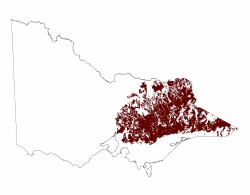 |
Related information on VRO
- A Study of the Land in the Catchment of the Kiewa River (R K Rowe 1972)
- A Study of the Land in the Buffalo National Park (R K Rowe 1970)
- A Study of the Land in the Upper Ovens and King Rivers ( R K Rowe 1952)
- A Study of the Land in the Victorian Catchment of Lake Hume (R K Rowe 1967)
- A Study of the Land in the Catchment of Gippsland Lakes, Volume 1 (J M Aldrick 1988)
- A Study of the Land in the Catchment of Gippsland Lakes, Volume 2 (J M Aldrick 1988)
- Land Inventory of East Gippsland - A Reconnaissance Survey Technical Report No. 23 (D B Rees, 1996)
- A Study of the Land in the Catchment of Lake Eildon (A S Rundle 1977)
- Land Resource Assessment in the Western part of the Shire of Towong (R Hook and D Rees 1999)
- Reconnaissance Survey of the Middle Reaches of the Goulburn River Catchment (Edited by L A White 1990)
- A Study of the Land in the Catchment of the Broken River (A S Rune and R K Rowe 1974)
- Mount Dandenong Foothills - Land Capability Study - Kilsyth Study Area (M Ranson A Harris and B White 1978)
© State of Victoria (Agriculture Victoria) 1996 - .

This work, Victorian Resources Online, is licensed under a Creative Commons Attribution 4.0 licence. You are free to re-use the work under that licence, on the condition that you credit the State of Victoria (Agriculture Victoria) as author, indicate if changes were made and comply with the other licence terms.
The licence does not apply to ‘branding’ or some ‘images or photographs’ that may be owned by third parties. We ask you to seek prior approval to use images using the VRO feedback form. Access to higher quality images can also be provided on request.
This page was last updated on .