
1. Eastern Uplands (EU)
Victoria's Geomorphological Framework (VGF)
1.1.1 Summit plateaux (Mt Bogong, Baw Baw, Buffalo, Mt Wills)
1.1.2 Broad ridges, plateaux (Hotham-Lock Ridge, Mt Fainter Ridge, Barry Mountains, Davies Plain)
1.1.3 Enclosed landscapes of low relief (Horsehair Plain)
1.1.4 Capped (basalt) plains (Mt Jim-Bogong High Plains, Dargo Plains, Nunniong Plains)
1.2.1 Plateaux and broad ridges (Straghbogie, Koetong-Shelly, Errinundra, Kinglake, Olinda)
1.2.2 Enclosed landscapes of low relief (Fraser Tableland, Benambra)1.3.1 Low relief landscapes at low elevation (Cann River south, Silvan, Templestowe)
1.3.2 Enclosed landscapes of low relief (Murmungee, Omeo, Dargo, Buldah)
1.3.3 Terraces, fans and floodplains (Kiewa Valley, Wonnangatta Valley)
1.3.4 Karst with depressions (Buchan)
| The Eastern Victorian Uplands Geomorphic Division (Jenkin 1988) has been renamed the Eastern Uplands in this study. It is centred on the main divide in eastern Victoria, separating streams draining north to the Murray-Darling Basin from those flowing southwards directly to the sea. This divide has been commonly called the Great Dividing Range but it is here referred to as the Great Divide because, for much of its length it is not a prominent and distinct mountain range. In the Eastern Uplands it is quite variable in height and follows a meandering – in parts obscure – path as a parting of north and south draining river systems in an extensive area of mountain ridges and high plateau-like surfaces. High points to both its north and south are in many cases more elevated than the Great Divide itself. Sections such as the rectilinear ridge of the Barry Mountains are not typical. It is the largest and most diverse geomorphic region in the State. The main streams draining northwards are the Goulburn, Indi, Mitta Mitta, Kiewa, Ovens and King Rivers. The most important streams flowing southwards to the sea are the Latrobe, Thomson, Macalister, Mitchell, Tambo, Nicholson and Snowy Rivers and their tributaries. Apart from the Snowy River, these streams all reach the sea through the Gippsland Lakes of south-eastern Victoria. Further east, the Bemm, Cann and Genoa Rivers flow directly into Bass Strait to drain the eastern part of the Eastern Uplands. The Yarra River, the main river draining the south-western part of the region, flows into Port Philip Bay. | 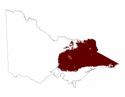 |
The major peaks on the Great Divide in the Eastern Uplands include Mt. Cobberas (1 833 m) just inside the eastern border with New South Wales, Mt Hotham (1 862 m) and Mt Howitt (1 746 m). Mt Bogong (1 986 m), Victoria’s highest mountain, is north of the Divide on a ridge that separates the upper reaches of the Mitta Mitta River from the Kiewa River. Other prominent peaks are Mt Feathertop (1 922 m) to the north of the Divide, on the ridge between the Kiewa and Ovens Rivers and Mt Buller (1 804 m) to the north west of Mt Howitt. Mt.Wellington (1 632 m) is a landmark at the southern end of the Snowy Range, a long ridge that extends south from Mt Howitt to form the divide between the Macalister and Wonnangatta Rivers, and on which Mt Reynard (1 737 m), is the highest point south of the Great Divide.
A dendritic pattern of narrow ridges and valleys (e.g. Jamieson and Upper Kiewa catchments) characterises much of this deeply dissected landscape on either side of the Great Divide. Occasional isolated summits (e.g Mt. Feathertop & Mt. Buller) occur on the narrow divides or stand above the remnant plateaus or broad ridges (Tiers 1.1.1 & 1.1.2)
Extensive landscapes of low relief (plateaus) occur at high elevations e.g. Bogong High Plains (about 1 500 – 1 600 m), the plateaus of Mt. Buffalo (about 1 400m) and Mt Baw Baw (about 1 567 m). These are commonly referred to as “high plains”. There are also extensive plateaus at successively lower elevations the further they are from the main divide, eg. the Pinnibar plateau in the north-east and the Nunniong plains to the south (about 1 200 m), the Koetong - Shelly, Wabonga and Strathbogie plateaus further north (about 600 - 1 100 m), and the Kinglake surface in the south west of the region at about 275 m.
The northerly draining valleys widen and the stream gradients gradually decrease as they near the Riverine Plain to the north and west of this region. The lower reaches of these streams have flood plains of fine sediments flanked by several sets of terraces. A landscape formed by the top terrace may be equivalent to the Nillumbik Terrain found south of the Great Divide. Alluvial or colluvial cones emerge from minor valleys of small ephemeral streams that drain the interfluves of major valleys. As the ridges approach the lowland plains, low hills mark the later stages of erosion of the upland ridges, e.g. the Lurg Hills near Benalla and the hills around Rutherglen.
The floodplain and terraces of the Murray River at Wodonga mark the eastern edge of the Northern Riverine Plain and the northern edge of the Eastern Uplands. At this point the floodplain is only about 150 m above sea level, consequently the major stream systems in this region have carved deep valleys, which in their upper reaches have steep gradients and flow in narrow valleys.
South of the Great Divide the streams have steeper gradients and deeper valleys, and as they approach the Eastern Plain, having narrower alluviated valleys than those in the north. The southern boundary of the Eastern Uplands is the southern edge of an uneven bench-like platform known as the Nillumbik Terrain, which can be traced bordering the Eastern Plain from near Orbost to the eastern suburbs of Melbourne. The Eastern Uplands extend to the coast from Cape Conran to Rams Head, where the Nillumbik Terrain is absent, and is fringed with coastal sand dunes in parts (Tier 8.4 & 8.5).
Major areas of low relief enclosed by steep ridges e.g. the Murmungee basin south of Beechworth and the Dargo area south of the Divide, occur in parts of the Eastern Uplands. These are found where more readily weathered and eroded rocks occur surrounded by resistant rocks, especially where igneous intrusions have created resistant metamorphic aureoles, or may be formed by down faulting as in the Lake Omeo basin.
The geology of much of the region is intensely folded Lower Palaeozoic sedimentary rocks or regionally metamorphosed derivatives (gneiss and schist). Granite intrusions have formed Mt. Buffalo and the Baw Baw Plateau, and underly the Koetong-Shelly plateau and the Strathbogie tablelands.
A belt of slightly dipping Upper Devonian – Lower Carboniferous non-marine sedimentary rocks with included rhyolitic volcanic rocks extends in a NW-SE direction through Mansfield, between the Macalister and Mitchell valleys, to the Eastern Plains in the south. Resistant Upper Devonian rhyolitic volcanic rocks and sandstones have had a conspicuous influence on landscape development, as seen in the Toombullup plateau and the Cobbler Plateau to the north and the Wellington Plateau south of the Great Divide.
Flat-lying basalt from the Palaeogene (Older Volcanics) occurs as residuals in elevated areas of low relief, e.g. on the Bogong High Plains, the Dargo High Plains, the Nunniong Plateau and Mt Useful.
Faulting has resulted in vertical separation of some of these landscapes and has influenced the courses of some of the major streams (e.g the West Kiewa River, Livingstone Creek and parts of the Mitta Mitta River).
Tall forests of Alpine Ash occur on the upper mountain slopes, and mixed-species eucalypt forests are typical over the remainder of the Eastern Uplands.
On the high plains, grasslands are widespread in areas where cold air drainage limits woody plant growth, with Sphagnum bogs and fens in permanently wet areas. Snow Gum woodlands occupy rocky knolls and ridges
The Eastern Uplands meet the Western Uplands at the Kilmore Gap just north of Melbourne at an elevation of only 350 m.
© State of Victoria (Agriculture Victoria) 1996 - .

This work, Victorian Resources Online, is licensed under a Creative Commons Attribution 4.0 licence. You are free to re-use the work under that licence, on the condition that you credit the State of Victoria (Agriculture Victoria) as author, indicate if changes were made and comply with the other licence terms.
The licence does not apply to ‘branding’ or some ‘images or photographs’ that may be owned by third parties. We ask you to seek prior approval to use images using the VRO feedback form. Access to higher quality images can also be provided on request.
This page was last updated on .