
1.1 Landscapes above 1200 m of low relief
1. Eastern Uplands (EU)
1.1.1 Summit plateaux (Mt Bogong, Baw Baw, Buffalo, Mt Wills)
1.1.2 Broad ridges, plateaux (Hotham-Lock Ridge, Mt Fainter Ridge, Barry Mountains, Davies Plain)
1.1.3 Enclosed landscapes of low relief (Horsehair Plain)
1.1.4 Capped (basalt) plains (Mt Jim-Bogong High Plains, Dargo Plains, Nunniong Plains)
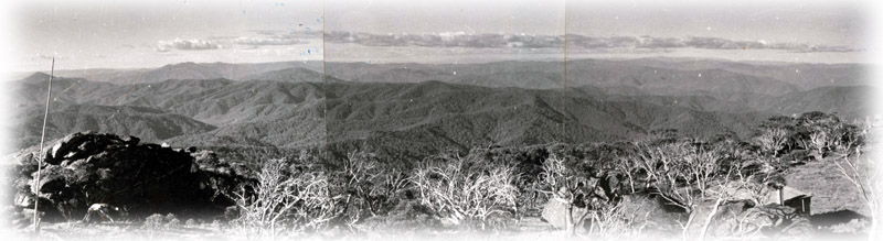 |
| The massive dissection of extensive areas of low relief at high elevation by the major drainage systems has left plateau remnants with elevations ranging from 1 000 m to 1 986 m (Mt. Bogong). Included are the granitic plateaus of Mt. Baw Baw and Mt. Buffalo, and the Bogong High Plains that is largely underlain by gneiss and schists and some granites/granodiorites. The southwestern part of the Bogong High Plains is covered by basalt of the Older Volcanics, with Basalt Hill, Mt. Jim and Ruined Castle showing columnar structure. Broad ridges extend north from the Bogong High Plains between the East and West Kiewa Rivers and from Rocky Valley through Mt. Nels to Spion Kopje. A narrow ridge joins this ridge to the broad summits of Mt. Bogong. Separated from the Bogong High Plains by the deep valleys of the West Kiewa River and the Cobungra River, the rounded ridges that peak at Mt. Hotham (1 862 m), have been termed the Hotham Tablelands. Its topography changes eastwards to a flat tableland on the Cobungra-Dargo divide. Discrete broad ridges found elsewhere are the Davies Plain Ridge, near Mt. Gibbo (1 757 m) and the Cobbler Plateau - correctly identified as a plateau - to the north of Mt Howitt. |  |
The Dargo High Plains, at about 1 500 m elevation, forms a wide semi-planar ridge summit, lower and less extensive than the Bogong High Plains and mostly formed on basalt (Older Volcanics).
The small ridge top area of low relief at about 1 400 m surrounding The Cobberas (or Mt. Cobberas, 1 832 m), at the head of the Buchan River, links eastwards with the lower Wulgulmerang Plateau. The Nunniong Plateau of about 1 500 m elevation, is a flat basalt residual (Older Volcanics) south of The Cobberas. The extensive Monaro Plateau of southern New South Wales gradually declines in elevation southwards and terminates sharply south of Bendoc with an elevation of about 900 m.
The four Tiers (1.1.1, 1.1.2, 1.1.3 and 1.1.4) are distinguished on the basis of predominant landform, and in the case of 1.1.4, by the presence of basalt cappings that have protected the ancient surface they overlie. It is sometimes difficult to delineate these units because they are often intimately associated (e.g. basalt capped parts of the Cobungra – Dargo divide) or they merge from one to the other (e.g. a plateau may narrow to become a broad ridge that has different environmental properties such as drainage and exposure).
Sub-alpine woodlands of Snow Gum are widespread. Open grasslands and herbfields, and heathlands are dominant communities over much of the area, and very limited but highly valued wetlands of fen and mossbed occur in association with permanent water.
The soils on much of these high plains and ridges are organic loams (Chernic Tenosols), shallow stony soils (Leptic Rudosols) and deeper well-structured gradational or uniform soils (Brown Dermosols).
Related information on VRO
- A Study of the Land in the Catchment of the Kiewa River (R K Rowe 1972)
- A Study of the Land in the Buffalo National Park (R K Rowe 1970)
- A Study of the Land in the Upper Ovens and King Rivers ( R K Rowe 1952)
- A Study of the Land in the Victorian Catchment of Lake Hume (R K Rowe 1967)
- A Study of the Land in the Catchment of Gippsland Lakes, Volume 1 (J M Aldrick 1988)
- A Study of the Land in the Catchment of Gippsland Lakes, Volume 2 (J M Aldrick 1988)
- Land Inventory of East Gippsland - A Reconnaissance Survey Technical Report No. 23 (D B Rees, 1996)
- A Study of the Land in the Catchment of Lake Eildon (A S Rundle 1977)
- Land Resource Assessment in the Western part of the Shire of Towong (R Hook and D Rees 1999)
© State of Victoria (Agriculture Victoria) 1996 - .

This work, Victorian Resources Online, is licensed under a Creative Commons Attribution 4.0 licence. You are free to re-use the work under that licence, on the condition that you credit the State of Victoria (Agriculture Victoria) as author, indicate if changes were made and comply with the other licence terms.
The licence does not apply to ‘branding’ or some ‘images or photographs’ that may be owned by third parties. We ask you to seek prior approval to use images using the VRO feedback form. Access to higher quality images can also be provided on request.
This page was last updated on .