
1.4.4 Deeply dissected ridge and valley landscapes (headwaters of major rivers such as the Wonnangatta, King and Kiewa Rivers, Mt Coopracambra)
1. Eastern Uplands (EU)
1.4 Dissected landscapes at a range of elevations
| High, narrow-topped ridges form the divides between the major streams, and steep spurs and side slopes extend down to steeply graded streams. Major stream systems (e.g. Thompson, Macalister, Wonnangatta / Mitchell, Kiewa, Mitta Mitta, upper Murray and Snowy Rivers) are deeply incised with intricately interlocking V-shaped spurs and tributary valleys, commonly with local relief of 500-700 m from ridge-top to valley bottom. The upper levels of the highest ridges are typically accordant with the high-level plateaus (about 1 500- 1 800 m), but most tend to be no higher than about 1 000-1 200 m, and decrease in height the further north or south they are from the high level landscapes. Some of the greatest drops from divide summits are at the head of the Wonnangatta River at Mt Howitt and the Crosscut Saw to Terrible Hollow on the Wonnangatta below, from the Snowy Plains and Mt Kent down to the Moroka River and the Wonnangatta River and from The Bluff to the Howqua River. The Barry Mountains, forming the Great Divide between the Mt Howitt area and the Mt Hotham district, is lower and less precipitous than those areas but is still a conspicuous range. In their upper reaches, stream gradients are steep, and down-cutting is still active so there is little or no accumulation of sediment along the stream margins. South of the Great Divide, gradients along the upper parts of streams are generally steeper than in the streams that drain to the north. The south flowing streams generally maintain steep sided valleys until they approach the Gippsland Riverine Plains (Tier 7.2), but divides gradually become lower and alluvial terraces border the streams from their middle tracts downstream. | 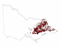 |
As the streams approach the lower landscapes of the Northern Riverine Plains (Tier 4) and the Eastern Plains (Tier 7), their gradient declines and alluvial deposits become increasingly more common along the stream banks until Tier 1.3.3 becomes dominant.
The vegetation is strongly influenced by soil moisture availability and elevation. The higher, sheltered aspects have tall open forest of alpine ash, with mountain gum and snow gum on drier or more exposed sites. At lower elevations, Narrow-leaf Peppermint, and Candlebark Gum, Manna Gum, and Victorian Blue Gum form open forests on moister sites. On drier sites, Red Stringybark, Broad Leaf-peppermint, Long-leaf Box and Red Box grow in low open forest formations. In general, all communities have a shrub layer of Sclerophyllous species that reflect the moisture status of the site.
Soils vary from red and brown gradational soils (Dermosols) on the moister and more stable slopes to poorly structured gradational soils (Kandosols) on the drier slopes. Soils on steep slopes are usually shallow with abundant stones.
© State of Victoria (Agriculture Victoria) 1996 - .

This work, Victorian Resources Online, is licensed under a Creative Commons Attribution 4.0 licence. You are free to re-use the work under that licence, on the condition that you credit the State of Victoria (Agriculture Victoria) as author, indicate if changes were made and comply with the other licence terms.
The licence does not apply to ‘branding’ or some ‘images or photographs’ that may be owned by third parties. We ask you to seek prior approval to use images using the VRO feedback form. Access to higher quality images can also be provided on request.
This page was last updated on .