
A Study of Land in the Catchments of the Otway Range and Adjacent Plains
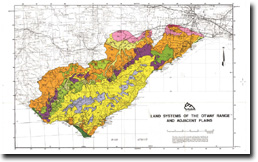
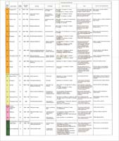
The report: "A Study of the Land in the Catchments of the Otway Range and Adjacent Plains" was prepared by Tony Pitt and published by the former Soil Conservation Authority in 1981 (Technical Communication 14). In the report, some 43 Land Systems have been delineated and described as well as 48 soil groups.
 | A Study of Land in the Catchments of the Otway Range and Adjacent Plains (PDF - 4132 KB) A Study of Land in the Catchments of the Otway Range and Adjacent Plains (DOC - 16008 KB) To view the information PDF requires the use of a PDF reader. This can be installed for free from the Adobe website (external link). |
© State of Victoria (Agriculture Victoria) 1996 - 2025.

This work, Victorian Resources Online, is licensed under a Creative Commons Attribution 4.0 licence. You are free to re-use the work under that licence, on the condition that you credit the State of Victoria (Agriculture Victoria) as author, indicate if changes were made and comply with the other licence terms.
The licence does not apply to ‘branding’ or some ‘images or photographs’ that may be owned by third parties. We ask you to seek prior approval to use images using the VRO feedback form. Access to higher quality images can also be provided on request.
This page was last updated on 23/03/2020.